
Remote-sensing image building detection method based on multi-scale and multi-characteristic fusion

A multi-feature fusion, remote sensing image technology, applied in instruments, computing, character and pattern recognition, etc., can solve the problems of reducing extraction efficiency, building size, shape, orientation, ignoring the special structure of buildings, etc. Accuracy and efficiency, the effect of automatic extraction

Active Publication Date: 2017-08-25
CHONGQING GEOMATICS & REMOTE SENSING CENT +1
View PDF6 Cites 18 Cited by
  • Summary
  • Abstract
  • Description
  • Claims
  • Application Information

AI Technical Summary

Problems solved by technology

However, most of the existing features only take into account the texture information of the building, while ignoring the special structure of the building, etc., and it is difficult to solve the shadow occlusion of buildings and the different sizes, shapes, and orientations of buildings in high-resolution remote sensing images. question
At the same time, most of the current methods with better extraction effects rely on the support of LiDAR, DSM, GIS vector data and other auxiliary data, which complicates the detection process and data and reduces the extraction efficiency.

Method used


Image

  • Remote-sensing image building detection method based on multi-scale and multi-characteristic fusion
  • Remote-sensing image building detection method based on multi-scale and multi-characteristic fusion
  • Remote-sensing image building detection method based on multi-scale and multi-characteristic fusion

Examples


Embodiment Construction

[0059]The specific implementation manner and working principle of the present invention will be further described in detail below in conjunction with the accompanying drawings.

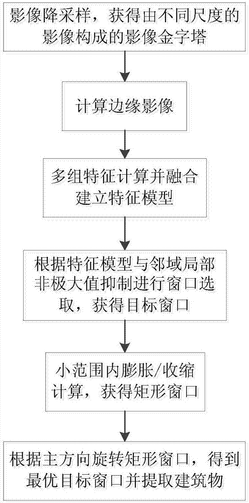
[0060] Such as figure 1 As shown, a remote sensing image building detection method based on multi-scale and multi-feature fusion is carried out according to the following steps:

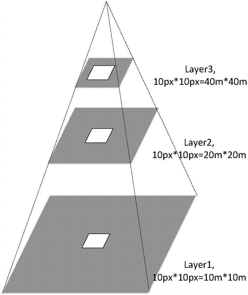
[0061] S1: The size, position, and orientation of buildings in high-resolution remote sensing images vary greatly. It is difficult to detect buildings of different sizes from a single scale. Therefore, firstly, down-sample the high-resolution images. Get the image pyramid;

[0062]

[0063] Use the above Gaussian function to smooth the image, where W(p,q)=W(p)*W(q) represents a Gaussian convolution kernel with a length of 5, and (p,q) are the coordinates of the midpoint of the Gaussian convolution kernel , (i,j) is the coordinates of the midpoint of the image. Thus, an image sequence {ML, ML-1, . . . , M0} with decreas...


PUM


Abstract

The invention discloses a remote-sensing image building detection method based on multi-scale and multi-characteristic fusion. The method comprises steps that through high resolution remote-sensing image downsampling, an image pyramid formed by images in different scales is acquired; edge images of the image pyramid are calculated; a characteristic model is established through multi-set characteristic calculation and fusion of the edge images in different scales; according to the characteristic model and neighborhood local non-maximum inhibition, window selection is carried out to acquire a target window; small-scope expansion / contraction calculation of the target window is carried out to acquire a rectangular window; the rectangular window is turned according to a main direction of the target window to acquire an optimal target window, and a building is extracted according to the optimal target window. The method is advantaged in that multi-scale building detection on the Gaussian pyramid image is carried out, universality of detection on buildings different in sizes, shapes and directions is realized, and automatic building detection precision and efficiency are effectively improved.

Description

technical field [0001] The invention relates to the technical field of remote sensing image processing, in particular to a remote sensing image building detection method based on multi-scale and multi-feature fusion. Background technique [0002] Buildings, as one of the main types of urban features, are thematic elements that must be highlighted in the large-scale basic geographic map of the city. Accurate building information can be used for land management, urban planning and other government departments to carry out land use status investigation and macro planning It provides important decision support for work such as digital city construction, investigation of illegal buildings and military reconnaissance and other fields. [0003] In high-resolution images, buildings have various shapes and sizes, and some are even obscured by neighboring trees, resulting in missing shapes. It is difficult to describe with a unified shape model, making automatic detection of buildings...

Claims


Application Information

Patent Timeline
Patent Type & Authority Applications(China)
IPC IPC(8): G06K9/00
CPCG06V20/176G06V20/20
Inventor 胡艳胡翔云丁忆李朋龙徐永书李静吴柳青罗鼎陈静宫金杞王小攀段松江陈雪洋
Owner CHONGQING GEOMATICS & REMOTE SENSING CENT
Learn More