Method for constructing BIM engineering investigation information system based on revit volume model

An engineering survey and information system technology, applied in the field of BIM geotechnical engineering, can solve the problems that engineering survey data cannot be directly imported

Inactive Publication Date: 2017-03-29
WUHAN SURVEYING GEOTECHN RES INST OF MCC
View PDF4 Cites 11 Cited by
  • Summary
  • Abstract
  • Description
  • Claims
  • Application Information

AI Technical Summary

Problems solved by technology

[0005] In order to overcome the deficiencies of the prior art, the present invention provides a method for constructing a BIM engineering survey information system based on a Revit volume model, which solves the problem in the prior art that engineering survey data cann

Method used


Image

  • Method for constructing BIM engineering investigation information system based on revit volume model
  • Method for constructing BIM engineering investigation information system based on revit volume model
  • Method for constructing BIM engineering investigation information system based on revit volume model

Examples


Embodiment Construction

[0018] The present invention will be further described below in conjunction with the drawings.

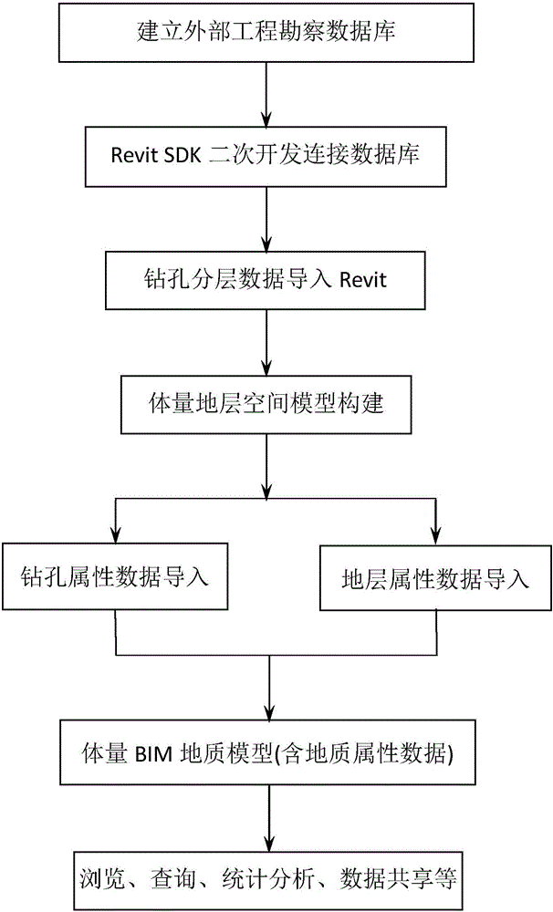
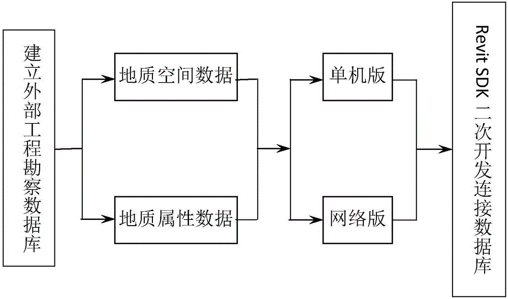
[0019] Combine figure 1 figure 2 image 3 , The method for constructing a BIM engineering survey information system based on the Revit mass model proposed by the present invention specifically includes the following steps:

[0020] Use Revit SDK secondary development to quickly import engineering survey data, build BIM engineering survey geological model based on Revit mass modeling method, and use engineering survey external database to integrate engineering survey geological spatial data and attribute data into the mass model to achieve Build a BIM engineering survey information system with functions including browsing, querying (real-time reading of borehole coordinates, boundary space position of any spatial strata, average thickness, physical and mechanical parameters, test data and other survey information), statistical analysis, data sharing, etc. . It includes the following s...


PUM


Abstract

The invention discloses a method for constructing a BIM engineering investigation information system based on a revit volume model. The method comprises the following steps: connecting and developing an external engineering investigation database by using a Revit SDK secondary development platform, and importing engineering investigation drilling data into Revit; converting the drilling data into adaptive point coordinate data that can be identified by volume modeling in the Revit, and establishing an engineering investigation BIM geological space model by using a volume modeling method; connecting an external geological attribute database, endowing geological attributes to the volume model, and associating spatial data with geological attribute data; and then constructing the BIM engineering investigation information system having browsing, query, statistical analysis, data sharing and other functions in a manner of adding a selection set. The difficulty that engineering investigation data cannot be imported into the Revit to construct the BIM engineering investigation information system in the prior art is solved, and a BIM engineering investigation basic matching model and data are provided for upstream and downstream of BIM building, structure, construction and other constructional engineering fields.

Description

Technical field [0001] The invention relates to the technical field of BIM geotechnical engineering in construction engineering, in particular to a method for constructing a BIM engineering survey information system based on a Revit mass model. Background technique [0002] With the gradual widespread application of BIM technology in the field of construction engineering, as a part of the field of BIM construction engineering, BIM geotechnical engineering survey provides indispensable basic data for subsequent BIM engineering design and construction, and plays an important role in engineering construction. Important role. [0003] As the mainstream software in the field of BIM construction engineering, Revit has powerful functions in architectural design, structural design and construction. Compared with it, due to the limitations of Revit conventional rule modeling, plus the geotechnical engineering survey industry involved The unknown underground space is complex, with large flu...

Claims


Application Information

Patent Timeline
IPC IPC(8): G06F17/50
CPCG06F30/13
Inventor 雷志娟杜坤乾李国祥陶冬艳柳文静
Owner WUHAN SURVEYING GEOTECHN RES INST OF MCC
Why Eureka
Try Eureka