Method for expressing road network trajectory data again

A technology of trajectory data and road network, which is applied in the fields of electronic digital data processing, structured data retrieval, geographic information database, etc., and can solve the problems of redundancy and unfavorable data compression.

Active Publication Date: 2017-02-15
FUDAN UNIV
View PDF4 Cites 5 Cited by
  • Summary
  • Abstract
  • Description
  • Claims
  • Application Information

AI Technical Summary

Problems solved by technology

[0004] Since the original road network trajectory data is sampled from the mobile positioning equipment, it is usually expressed as a triple sequence T=1 ,y 1 , t 1 ), (x 2 ,y 2 , t 2 ),..., (x n ,y n , t n )>, however, this representation contains unnecessary redundancy, which is not conducive to data compression

Method used


Image

  • Method for expressing road network trajectory data again
  • Method for expressing road network trajectory data again
  • Method for expressing road network trajectory data again

Examples


Embodiment Construction

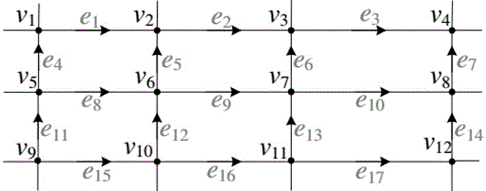
[0055] In the following, the data format and trajectory decomposition method will be introduced in conjunction with the example road network and trajectory.

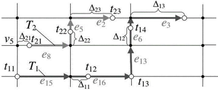
[0056] Such as figure 1 As shown in , a given road network contains 12 vertices (intersections) and 17 edges (roads). Consider trajectory 1 (blue trajectory), since the trajectory has been map-matched, all sampling points have been mapped to the road. exist figure 2 In the sample point 11 corresponding side 15 ;Sampling point 12 corresponding side 16 ;Sampling point 13 corresponding side 13 ;Sampling point 14 corresponding side 16 ;Sampling point 15 corresponding side 3 . Note that if the sampling point happens to be at an intersection, the latter edge instead of the previous edge should be uniformly taken as the corresponding road sequence item, such as the sampling point 13 corresponding side 13 instead of 16 . so 1 road sequence SP 1 =15 , e 16 , e 13 , e 6 , e 3 >.

[0057] To compute the corr...


PUM


Abstract

The invention belongs to the technical field of trajectory data calculation, and particularly relates to a method for expressing road network trajectory data again. The road network trajectory data obtained by original GPS (Global Positioning System) sampling is difficult in coding compression, and therefore, an original three-dimensional real number sequence needs to be changed before compression is carried out. By use of the method, a road network trajectory matched with a map is decomposed into spatial data and time data, wherein the spatial data is a road network road sequence, the time data is a distance-time two-tuple sequence, and data before and after decomposition is carried out can be subjected to lossless transformation in linear time. During trajectory calculation, trajectory storage and query cost in a database can be reduced.

Description

technical field [0001] The invention belongs to the technical field of trajectory data calculation, and in particular relates to a method for re-expressing road network trajectory data. Background technique [0002] Trajectory data is a basic spatiotemporal data, usually defined as a function of position with respect to time. The trajectory points sampled by the vehicle positioning equipment are represented by (x, y, t) triplets, where x and y are longitude and latitude respectively, and t is the time stamp of the sampling point. So the original road network trajectory can be represented by a sequence of triples, that is, <(x 1 ,y 1 , t 1 ), (x 2 ,y 2 , t 2 ),…, (x n ,y n , t n )>, where n is the length of the trajectory, and (x i ,y i ) is the vehicle at t i position at the moment. With the popularization of vehicle-mounted positioning equipment, vehicles in cities have generated massive road network trajectories. These road network trajectory data carry...

Claims


Application Information

Patent Timeline
Patent Type & Authority Applications(China)
IPC IPC(8): G06F17/30
CPCG06F16/29
Inventor 孙未未韩韵衡
Owner FUDAN UNIV
Why Eureka
Try Eureka