Indoor positioning method and system for UAV

An indoor positioning and UAV technology, applied in navigation, instrumentation, surveying and navigation, etc., can solve the problem of lack of accurate estimation of location information and methods of tracking location changes, inability to accurately estimate UAV spatial six-degree-of-freedom positioning information, Lack of position information can rely on features and other issues to achieve high positioning stability and achieve the effect of precise flight control

Active Publication Date: 2017-10-27
SHENZHEN UNIV
View PDF8 Cites 0 Cited by
  • Summary
  • Abstract
  • Description
  • Claims
  • Application Information

AI Technical Summary

Problems solved by technology

[0010] 1. Lack of reliable features that can be used to accurately judge location information
[0011] 2. Lack of methods that can be used to accurately estimate location information and track location changes
[0012] 3. Unable to accurately estimate the six-degree-of-freedom positioning information of the UAV space

Method used


Image

  • Indoor positioning method and system for UAV
  • Indoor positioning method and system for UAV
  • Indoor positioning method and system for UAV

Examples


Embodiment Construction

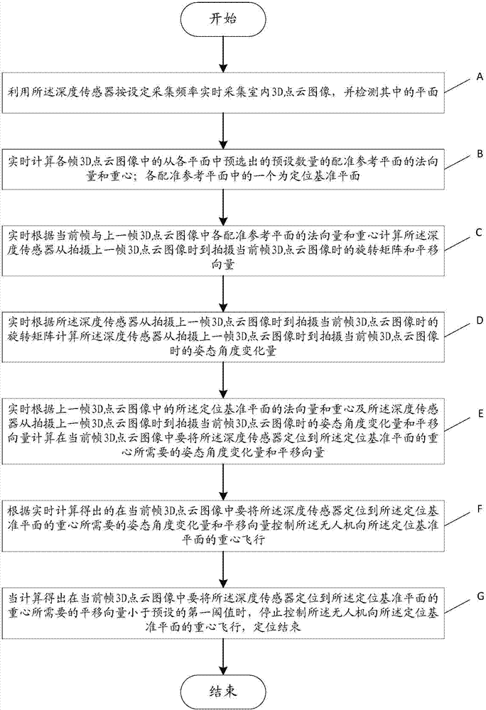
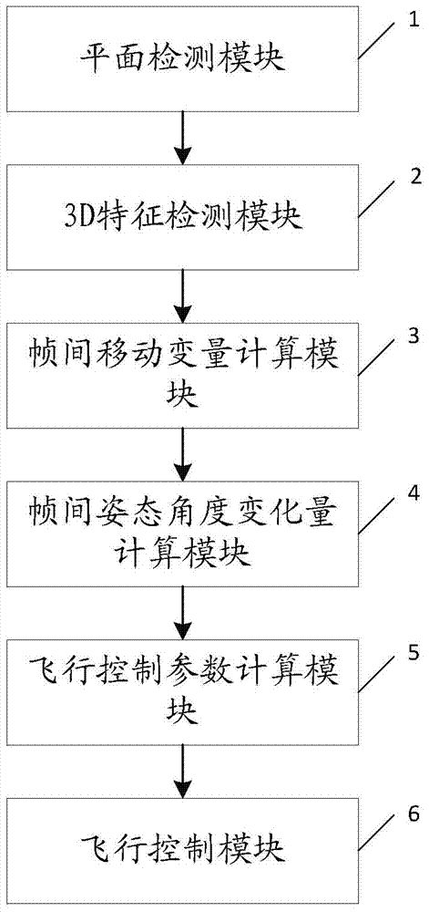
[0064] In order to make the object, technical solution and advantages of the present invention clearer, the present invention will be further described in detail below in conjunction with the accompanying drawings and embodiments. The basic idea of ​​the present invention is to collect indoor 3D point cloud images in real time through the depth sensor installed on the UAV, and locate the UAV according to the 3D features of the plane in the 3D point cloud image. The 3D feature of the corresponding plane in the adjacent frame 3D point cloud image changes the position of the drone between adjacent frames, and tracks the position change of the drone in real time according to the position change, so as to control the flight of the drone , to achieve positioning. to combine figure 1 , the UAV indoor positioning method provided by the present invention comprises the following steps:

[0065] Step A: Use the depth sensor to collect the indoor 3D point cloud image in real time accord...


PUM


Abstract

The invention relates to the technical field of indoor positioning, in particular to an indoor positioning method and system for an unmanned aerial vehicle. A depth sensor mounted on the unmanned aerial vehicle is adopted for collecting an indoor 3D (three-dimensional) point cloud image in real time and detecting the plane in the 3D point cloud image, and normal vector and gravity center of the plane are used as dependent properties of positioning; compared with positioning based on three-dimensional characteristics of a point, the indoor positioning is higher in stability and position formation of the unmanned aerial vehicle can be accurately judged; meanwhile, position change information of the inter-frame depth sensor is calculated in real time through normal vector and gravity center of each inter-frame registered reference plane, the position change information of the unmanned aerial vehicle can be accurately traced in real time, and accurate flight control on the unmanned aerial vehicle is realized.

Description

technical field [0001] The invention relates to the technical field of indoor positioning, in particular to an indoor positioning method and system for a drone. Background technique [0002] In the past ten years, in order to solve the "last mile" problem of positioning, various scientific research institutions and entrepreneurial companies have carried out a lot of research on indoor positioning, aiming to find a good indoor positioning solution. [0003] At present, there are mainly four positioning systems in existence: [0004] The first type: a satellite positioning system based on GPS or Beidou. However, its main application is outdoor positioning, which is not suitable for indoor positioning, and its positioning error is relatively large. [0005] The second type: WIFI-based positioning. It is very convenient, but due to the refraction, reflection, non-line-of-sight factors, signal dead angle and 2.4GHz and other high-frequency interference during signal propagatio...

Claims


Application Information

Patent Timeline
Patent Type & Authority Patents(China)
IPC IPC(8): G01C21/00
CPCG01C21/206
Inventor 蒙山贾康
Owner SHENZHEN UNIV
Why Eureka
Try Eureka