Eureka AIR delivers breakthrough ideas for toughest innovation challenges, trusted by R&D personnel around the world.

Method for generating road network map based on bus GPS data

A GPS data and bus technology, applied in the field of intelligent transportation systems, can solve the problems of difficulty in generating maps and the impact on accuracy, high purchase cost of remote sensing images, and road network can not be quickly reflected, etc., to achieve fast acquisition speed and practicality Strong, low data cost effect

Active Publication Date: 2015-06-24
SHANDONG UNIV
View PDF5 Cites 26 Cited by
  • Summary
  • Abstract
  • Description
  • Claims
  • Application Information

AI Technical Summary

Problems solved by technology

Manual surveying and mapping can obtain detailed and high-precision road network maps, but their production costs are high and the update cycle is long. When urban roads are rebuilt or temporarily closed, the original road network cannot quickly reflect the real road network situation; for remote sensing images First, the purchase cost of the required remote sensing images is relatively high, and the purchased images are usually not currently reflected in the road network. In addition, the difficulty and accuracy of generating maps are easily affected by the quality of remote sensing images

Method used


Image

  • Method for generating road network map based on bus GPS data
  • Method for generating road network map based on bus GPS data
  • Method for generating road network map based on bus GPS data

Examples


Embodiment 1

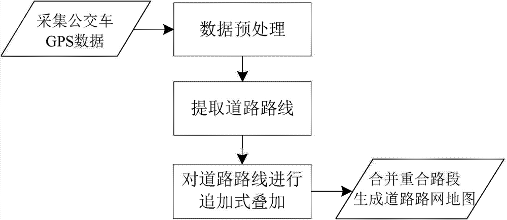
[0064] A method for generating a road network map based on bus GPS data, the specific steps comprising:

[0065] (1) Select the urban area that needs to generate a road network map, collect the GPS data of each bus in the urban area, and group and store the GPS data of each bus collected according to the bus route number;

[0066] (2) Preprocessing the GPS data of each bus stored: the GPS data of the uplink bus and the GPS data of the downlink bus of each route are separated, and two different data sets are obtained on each route. After the GPS data of the uplink bus and the GPS data of the downlink bus of all routes are separated, all data sets are obtained, and then each data set is filtered;

[0067] Each route runs in opposite directions from two starting and ending points, which are divided into uplink and downlink. For example, if the starting point of a line is A and the end point is B, then the direction from A to B is downlink, and the direction from B to A is uplink....

Embodiment 2

[0073] According to the method for generating a road network map described in embodiment 1, the difference is that in the step (1), the specific steps include:

[0074] a, collect the GPS data of the bus in the urban area that needs to generate the road network map, the GPS data of the bus includes: route number, vehicle ID, time, longitude value, latitude value, speed, the number of passing stations, according to the bus Bus route number, group and store the collected GPS data of each bus;

[0075] b. Construct a blank road network grid map: divide the blank road network grid map into a large number of small areas;

[0076] The area of ​​the small area is 1 / 10000°×1 / 10000°, that is, the length of the small area is 0.0001 longitude, and the width is 0.0001 latitude.

Embodiment 3

[0078] According to the method for generating the road network map described in embodiment 1 or 2, the difference is that in the step (2), the GPS data of each bus stored is preprocessed, and the specific steps include:

[0079] c, data separation, that is, the GPS data of the uplink bus of each route and the GPS data of the downlink bus are separated, and two different data sets are obtained on each route; the GPS of the uplink bus of all routes After the data and the GPS data of the downlink bus are separated, all the data sets are obtained;

[0080] d. Data filtering, that is, filtering the data set obtained in step c, specifically referring to: according to the longitude and latitude range of the urban area where the road network map needs to be generated, for the longitude and latitude values ​​in the GPS data of each bus in the data set , to remove out-of-boundary data that is not in the longitude and latitude range of the urban area where the road network map needs to b...


PUM


Abstract

The invention relates to a method for generating a road network map based on bus GPS data. The method comprises the steps that 1, an urban region which needs to generate the road network map is selected, and GPS data of each bus are collected; 2, preprocessing is conducted on the stored GPS data of each bus, and separation is conducted on the GPS data of upstream buses and the GPS data of downstream buses on each route; 3, a road route is extracted; 4, superposition is conducted on the road route through a supplementary mode; 5, repeatability between road sections of the road route is judged, overlap road sections are combined, and an integrated road network map is generated. According to the method for generating the road network map based on the bus GPS data, the more accurate road network map with a clear direction is obtained, and the application of route guidance is facilitated; compared with a traditional map making method, the cost of obtaining data is low, the speed of obtaining is fast; the method for generating the road network map based on the bus GPS data has the advantages of being concise in steps and strong in practicability; the road network map can be rapidly generated through a software program, and a road network structure is updated in real time.

Description

technical field [0001] The invention relates to a method for generating a road network map based on bus GPS data, and belongs to the technical field of intelligent transportation systems. technical background [0002] In recent years, my country's urban development has advanced by leaps and bounds, and the urban population has increased dramatically. With the leap in the number of motor vehicles and the lag of urban road construction, urban traffic problems have become increasingly prominent. As a response to this situation, intelligent transportation technology has gradually shown its importance. sex. Urban road network maps are the basis of intelligent transportation systems, and are widely used in vehicle navigation and guidance systems. Based on the real-time traffic operation status, the vehicle navigation and guidance system can use advanced information technology and network communication technology to plan and guide the vehicle's driving route reasonably, avoid traff...

Claims


Application Information

Patent Timeline
IPC IPC(8): G08G1/0968
CPCG08G1/0141
Inventor 邢建平陆晓燕孟令国李慧恬綦中平武勇
Owner SHANDONG UNIV
Why Eureka
Eureka Blog
Learn More