Low-altitude wind shear three-dimensional backscattering wave simulation method for airborne meteorological radar

An airborne weather radar and low-altitude windshear technology, applied to radio wave measurement systems, instruments, etc., can solve the problems of difficult acquisition of measured data, short duration, and large impact intensity, and achieve effective and reliable simulation data

Inactive Publication Date: 2015-05-06
CIVIL AVIATION UNIV OF CHINA
View PDF1 Cites 16 Cited by
  • Summary
  • Abstract
  • Description
  • Claims
  • Application Information

AI Technical Summary

Problems solved by technology

[0008] The echo signal simulation of airborne weather radar has been paid more and more attention. On the one hand, with the continuous development of radar, the functions are more powerful and the types are more diverse. The use of field experiments to test radar performance and indicators can no longer meet the needs; on the other hand , for the study of low-altitude wind shear, it has the characteristics of sudden occurrence, short duration, strong impact intensity, high risk and difficult detection, so the measured data is not easy to obtain

Method used


Image

  • Low-altitude wind shear three-dimensional backscattering wave simulation method for airborne meteorological radar
  • Low-altitude wind shear three-dimensional backscattering wave simulation method for airborne meteorological radar
  • Low-altitude wind shear three-dimensional backscattering wave simulation method for airborne meteorological radar

Examples


Embodiment Construction

[0036] The method for simulating three-dimensional echoes of airborne weather radar at low altitude and windshear provided by the present invention will be described in detail below in conjunction with the accompanying drawings and specific embodiments.

[0037] Such as Figure 5 As shown, the airborne weather radar low-altitude windshear three-dimensional echo simulation method provided by the present invention comprises the following steps carried out in order:

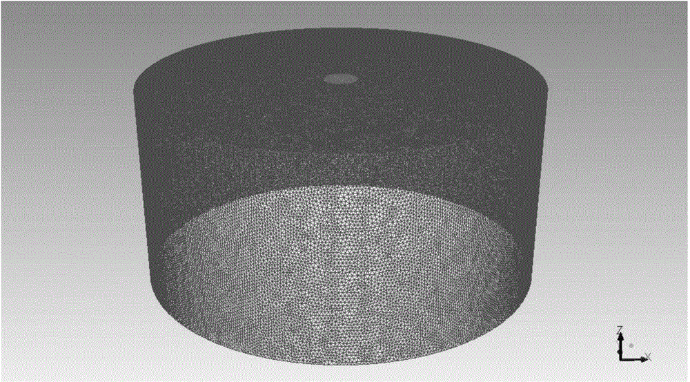
[0038] 1) Using scene parameters including scene range and boundary conditions, establish a three-dimensional meshed computational domain;

[0039] A microburst is a special low-altitude wind shear, and the method of the present invention uses a microburst model to model it, such as figure 1 As shown, the constructed scene range is a centrally symmetrical cylinder with a cylinder radius of 3000 meters and a cylinder height of 3000 meters. The boundary condition is an open outlet, a fluid inlet is set on the top of...


PUM


Abstract

The invention discloses a low-altitude wind shear three-dimensional backscattering wave simulation method for an airborne meteorological radar. The low-altitude wind shear three-dimensional backscattering wave simulation method comprises the following steps: establishing a three-dimensional meshed computational domain by utilizing scene parameters including a scene range and boundary conditions; performing fluid simulation on the computational domain to generate original wind field data; correcting the original wind field data; establishing an simulation scene and reading the corrected wind field data according to settings of the scene parameters; according to the simulation scene, simulating low-altitude wind shear of the airborne meteorological radar, and performing coherence stack on scattering points within a radar beam to form a radar backscattering wave signal of a scanning direction; respectively updating airplane position information, corrected wind field data and radar beam angle scanning information by utilizing the airborne parameters, the scene parameters and the scanning parameters; judging whether the scanning is completed or not according to a scanning range of the radar parameters. The method can be used for truly reflecting meteorological characteristics of the wind shear three-dimensional backscattering wave signal, so that the simulation data is effective and reliable.

Description

technical field [0001] The invention belongs to the technical field of radar echo signal simulation, in particular to a three-dimensional echo simulation method for low-altitude wind shear of an airborne meteorological radar. Background technique [0002] Low-altitude wind shear is one of the most harmful weather phenomena encountered by aircraft during takeoff and landing. When the aircraft passes through the center of the wind field in the area of ​​wind shear, it is affected by the sharply changing wind speed and downdraft, which will cause the aircraft to approach a stall. Due to the limited controllable height space during the take-off and landing phase of the aircraft, if the wind shear is strong, it is very easy to cause a serious crash. Since it is difficult to obtain real wind shear echo data, it is of great practical significance to carry out research on high-fidelity low-altitude wind shear three-dimensional echo simulation methods. [0003] The establishment of...

Claims


Application Information

Patent Timeline
Patent Type & Authority Applications(China)
IPC IPC(8): G01S7/40
CPCG01S7/4052
Inventor 吴仁彪刘夏李海韩雁飞
Owner CIVIL AVIATION UNIV OF CHINA
Why Eureka
Try Eureka