
The Method of Obtaining Power Grid Planning Data According to Regional Development Planning Map

A technology for power grid planning and planning diagrams, applied in image data processing, electrical digital data processing, special data processing applications, etc., can solve the problems of deviation of analysis results, difficulty in being accurate and fast

Active Publication Date: 2016-08-17
STATE GRID CORP OF CHINA +2
View PDF2 Cites 0 Cited by
  • Summary
  • Abstract
  • Description
  • Claims
  • Application Information

AI Technical Summary

Problems solved by technology

[0002] The power grid planning in the power system generally follows the empirical processing method, using the land use properties of different areas (such as industrial land, green land, etc.) formulated by the urban development plan to define the power load rate of different areas, and then integrate the power consumption in a certain area. Electric load, if it meets the needs of building substations, choose a reasonable location to build the substation. The previous analysis process basically relied on manual analysis and experience, which was difficult to be accurate and fast, resulting in large deviations in the analysis results. How to analyze quickly and accurately has always been a problem. a difficult problem

Method used


Image

  • The Method of Obtaining Power Grid Planning Data According to Regional Development Planning Map
  • The Method of Obtaining Power Grid Planning Data According to Regional Development Planning Map
  • The Method of Obtaining Power Grid Planning Data According to Regional Development Planning Map

Examples


Embodiment Construction

[0043] Below in conjunction with accompanying drawing, the present invention is further described:

[0044] The area development map mentioned in the description (such as figure 2 ) is to divide the area into different sub-areas according to different land use properties, which are marked in different colors and accompanied by corresponding legends in the figure.

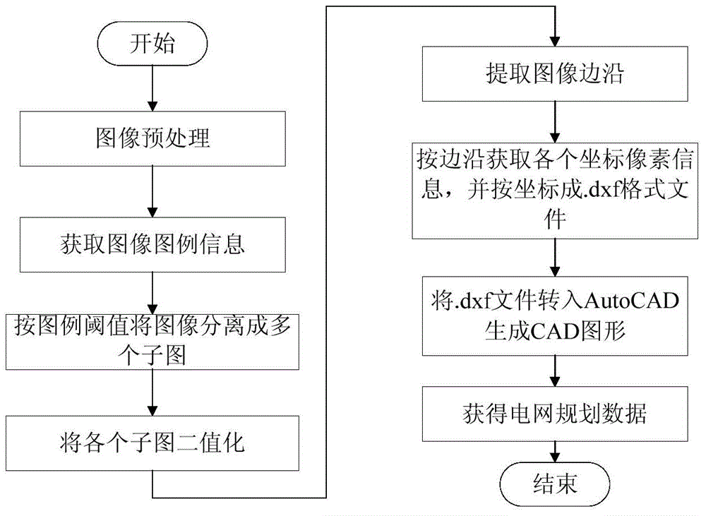
[0045] see figure 1 As shown, the method for obtaining power grid planning data according to the regional development planning map of the present invention includes the following steps:

[0046] The first step, preprocessing process: regional development planning map (such as figure 2 shown) is divided into three parts in the vertical direction, that is, title, main body area and legend from top to bottom. There will be two wide blank areas in the middle of these three parts. According to these two white areas, the planning map will be divided first.

[0047] Let the original image (color) of the regional deve...


PUM


Abstract

The invention discloses a method for obtaining grid planning data according to a regional development planning diagram, which includes: dividing the regional development planning diagram; obtaining legend information in the legend region; separating the same region in the main region of the planning diagram into independent image; perform binary processing on each sub-image; extract edges from the binary image; use the edge extraction results to obtain the .dxf files corresponding to each sub-image; transfer each .dxf file to AutoCAD to form each sub-image on different CAD layers The graphics in the CAD map; according to the area of ​​each layer in the CAD drawing and the nature of the planned land represented by the layer, the grid planning data of the area is obtained. The invention uses the image processing method to directly convert the schematic diagram of the development plan into CAD graphics in different layers according to the planned industry. This method is helpful for the design of power consumption properties and regions during the planning and design of the power grid, so that the planning results of the power grid are more accurate. Reliable and fast.

Description

【Technical field】 [0001] The invention belongs to the technical field of grid planning and design, and in particular relates to a method for obtaining grid planning data from a regional development planning map. 【Background technique】 [0002] The power grid planning in the power system generally follows the empirical processing method, using the land use properties of different areas (such as industrial land, green land, etc.) formulated by the urban development plan to define the power load rate of different areas, and then integrate the power consumption in a certain area. Electric load, if it meets the needs of building substations, choose a reasonable location to build the substation. The previous analysis process basically relied on manual analysis and experience, which was difficult to be accurate and fast, resulting in large deviations in the analysis results. How to analyze quickly and accurately has always been a problem. A difficult problem to solve. 【Content of...

Claims


Application Information

Patent Timeline
Patent Type & Authority Patents(China)
IPC IPC(8): G06T7/00G06F17/50
Inventor 蒋勃蒋琪武婷婷张燕涛李静郝伟李明张东正杨柳冯昆侯浩录李博江赵蕾何凯杨浩尚宏崔蕾黄虹朱春强李潼禹湘
Owner STATE GRID CORP OF CHINA
Learn More