Optimized display method of place name annotation image layer

A display method and place name technology, which is applied in the direction of digital output to display equipment, structured data retrieval, geographic information database, etc., can solve the problems of low display density, insufficient display content, and inability to guarantee the display effect, so as to ensure speed, Show content-rich, computationally-intensive effects

Inactive Publication Date: 2014-03-05
NO 54 INST OF CHINA ELECTRONICS SCI & TECH GRP
View PDF3 Cites 17 Cited by
  • Summary
  • Abstract
  • Description
  • Claims
  • Application Information

AI Technical Summary

Problems solved by technology

[0003] The traditional method is to classify the place name annotation, and determine the display level according to the size of the display range. The content above a certain level is displayed, and the content below a certain level is not displayed. In this way, when the display range is at a critical value, it may There is content display higher than a certain level, but the display density is low, the display content is not rich enough, and the screen display space is not effectively used; there is also a possibility that at this display level, there are still many display contents, and the interaction of place name annotations cannot be avoided Gland case, can not guarantee a good display effect

Method used


Image

  • Optimized display method of place name annotation image layer

Examples


Embodiment Construction

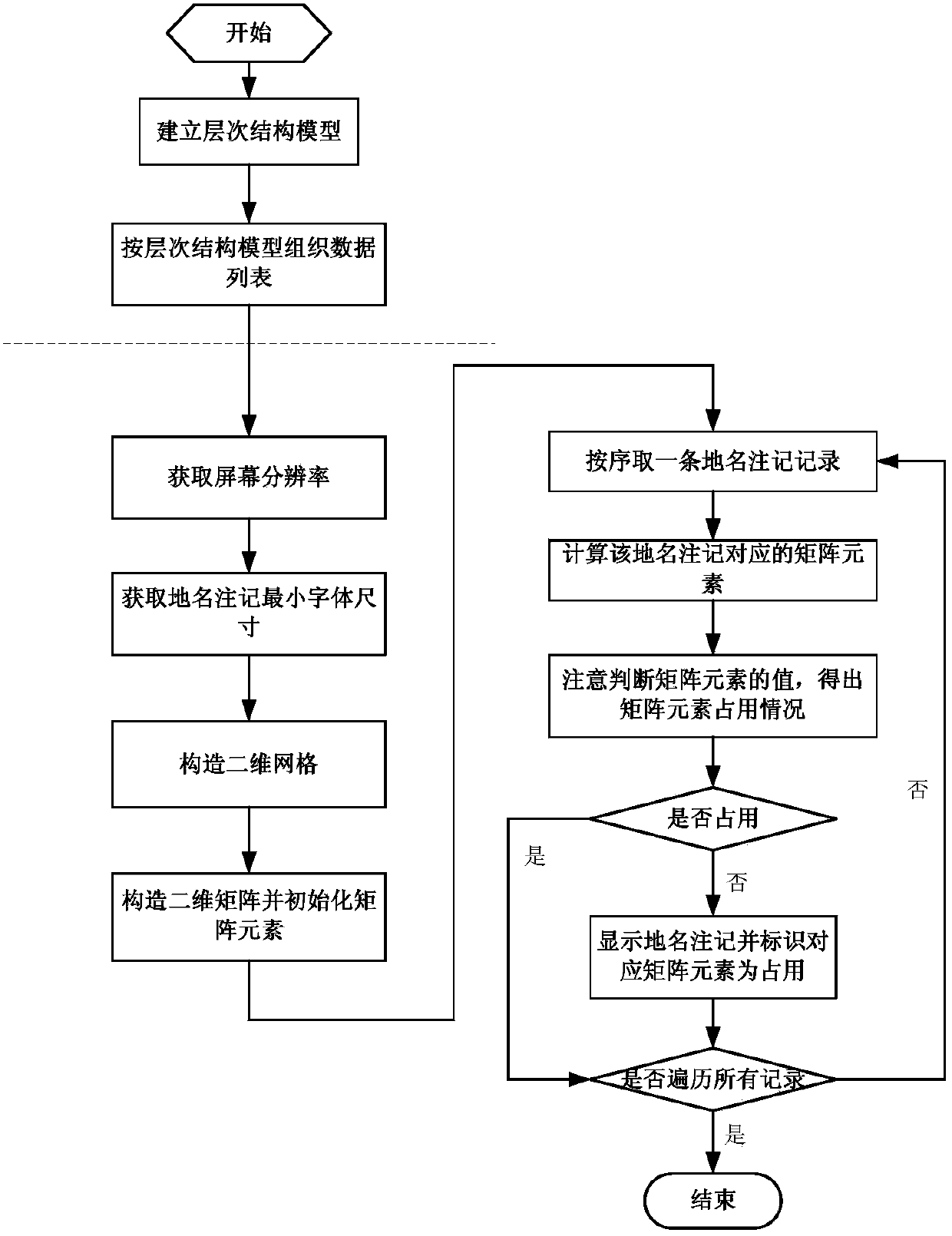
[0066] refer to figure 1 , the present invention classifies the place-name notes into multiple levels according to the importance of the place-name notes or the degree of concern of the user, and establishes a hierarchical structure model; obtains the size of the display screen, and divides the screen into a two-dimensional grid matrix; when displaying a For a place name, calculate the two-dimensional matrix element corresponding to the place name, and judge whether the corresponding grid is occupied; if it is occupied, the place name will not be displayed, otherwise, the place name will be displayed, and the corresponding grid will be marked as occupied; thus traversing all place name notes remember.

[0067] The present invention comprises the following steps:

[0068] (1) According to the importance of the place-name annotation or the degree of attention of users, the place-name annotation is classified into multiple levels, and a hierarchical structure model is establishe...


PUM


Abstract

The invention discloses an optimized display method of a place name annotation image layer, and relates to the place name annotation image layer optimized display technology in a cartographic generalization method of the geographic information processing field. The optimized display method includes the steps of classifying place name annotations into multiple grades according to the importance degrees of the place name annotations or the concern extents of users, building a grade structure model, obtaining the size of a display screen, dividing the display screen into a two-dimension grid matrix, when a place name is displayed, computing a two-dimension matrix element corresponding to the place name, judging whether a corresponding grid is occupied or not, enabling the place name not to be displayed if the corresponding grid is occupied, displaying the place name if the corresponding grid is not occupied, signing the corresponding grid to be in an occupation state, and traversing all the place name annotations in this way. According to the optimized display method, grading display of the place names is achieved, it can be guaranteed that the amount of display information is as large as possible under the condition that the place names are not covered absolutely, and the display speed is further guaranteed.

Description

technical field [0001] The invention relates to a cartographic synthesis method in the field of geographic information processing. Aiming at a large number of place-name annotation layers, an optimized display method for place-name annotation is proposed in combination with the importance level classification of the place-name annotation and the computer screen size. Background technique [0002] In various applications of geographic information, map display is a basic function. The place name annotation layer is an important information type in the vector map, which records a large number of place name annotation information related to the geographical location. Use geographic information as an important source of information. These place name annotations have different importance levels and a large amount of data. When displaying, ensure that the display content has a reasonable priority, the display content can be entered more, the annotation is clear and not overwritten, ...

Claims


Application Information

Patent Timeline
Patent Type & Authority Applications(China)
IPC IPC(8): G06F17/30
CPCG06F3/14G06F16/29
Inventor 彭会湘
Owner NO 54 INST OF CHINA ELECTRONICS SCI & TECH GRP
Why Eureka
Try Eureka