Method and system of three-dimensional geographic information system (GIS) terrain rendering

A terrain rendering and three-dimensional technology, applied in the field of image rendering, can solve the problems of large amount of interactive processing data, inability to accurately control errors, high CPU overhead, etc., to reduce CPU overhead, avoid processing difficulties, and improve speed.

Active Publication Date: 2013-04-10
ELECTRIC POWER RES INST OF GUANGDONG POWER GRID
View PDF5 Cites 8 Cited by
  • Summary
  • Abstract
  • Description
  • Claims
  • Application Information

AI Technical Summary

Problems solved by technology

[0003] 3D terrain rendering visualization needs to solve the core problem of the contradiction between the rendering speed of massive complex terrain models and the authenticity of rendering scenes, and the limited rendering capabilities of computer graphics hardware. Currently, the traditional LOD control method is generally used in the power industry. There are three main technologies for 3D GIS terrain rendering: one is implemented in the form of irregular triangular mesh (TIN), but this method is not conducive to scene rendering and management; the other is implemented in the form of Geometry Clipmaps (GC), but It cannot precisely control the error; the method based on quadtree segmentation is the most widely used
The advantage is that based on the dynamic construction of the CPU grid, combined with the viewpoint and grid roughness, the error can be well controlled, but due to the huge amount of interactively processed data, this method requires a large amount of pre-calculation, and the CPU overhead is very large , general CPU and bandwidth cannot achieve very high rendering speed and very realistic rendering effect

Method used


Image

  • Method and system of three-dimensional geographic information system (GIS) terrain rendering
  • Method and system of three-dimensional geographic information system (GIS) terrain rendering
  • Method and system of three-dimensional geographic information system (GIS) terrain rendering

Examples


Embodiment Construction

[0023] The present invention will be described in further detail below in conjunction with the embodiments and accompanying drawings, but the embodiments of the present invention are not limited thereto.

[0024] like figure 1 Shown is the schematic flow chart of the three-dimensional GIS terrain rendering method of the present invention in a preferred embodiment, comprising the following steps:

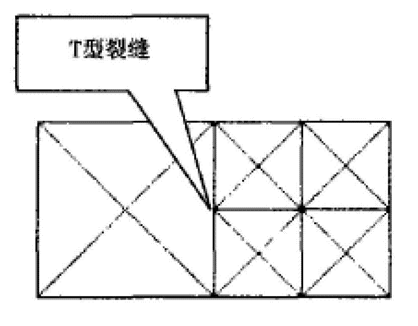
[0025] S11. Load the topographic data of the three-dimensional GIS, perform quadtree segmentation on the topographic data, and generate a rectangular grid of the topographic data;

[0026] Treat the acquired 3D GIS terrain data as a rectangular grid, perform quadtree segmentation on the entire terrain data, and divide the entire 3D GIS terrain data into multiple rectangular grids; figure 2 Shown is a schematic diagram of quadtree segmentation. The entire terrain map is recursively divided into quadtrees to obtain multiple small rectangular grids, so that the original terrain data i...


PUM


Abstract

The invention discloses a method of three-dimensional geographic information system (GIS) terrain rendering. According to the method of the three-dimensional GIS terrain rendering, quad-tree partitioning is carried out on terrain data loaded from the three-dimensional GIS to generate rectangular grids of the terrain data, viewing pyramid cutting is carried out on the rectangular grids to obtain rectangular grids needed to be displayed, the rendering accuracy of each rectangular grid needed to be displayed is calculated and then is judged whether the rendering accuracy of each rectangular grid reaches a preset standard, then the quad-tree partitioning is carried out again on each rectangular grid which does not reach the preset standard, and for each rectangular grid reaching the preset standard, terrain units are generated and rendered according to the terrain data corresponding to each rectangular grid. The invention further discloses a system of the three-dimensional GIS terrain rendering correspondingly. The method and the system of the three-dimensional GIS terrain rendering can effectively improve the speed of the three-dimensional GIS terrain scene rendering, and enables the data processing process to be simpler and more rapid.

Description

technical field [0001] The invention relates to the technical field of image rendering, in particular to a three-dimensional GIS terrain rendering method and a three-dimensional GIS terrain rendering system. Background technique [0002] In recent years, in the power industry, especially in the field of main network production, the use of 3D GIS to reproduce 3D terrain and solve business problems has attracted more and more attention from business departments, but the performance of the current 3D GIS products can no longer support the increasing business new requirements. Rendering technology is a core technology that affects the performance of 3D terrain simulation, so it has always been the research focus of computer graphics and geographic information systems and other related fields. [0003] 3D terrain rendering visualization needs to solve the core problem of the contradiction between the rendering speed of massive complex terrain models and the authenticity of rende...

Claims


Application Information

Patent Timeline
IPC IPC(8): G06T15/00G06T17/05
Inventor 魏焱杜旭齐志刚颜璟仪赖翠君陈炯聪洪成佳刘森甘杉汤彧
Owner ELECTRIC POWER RES INST OF GUANGDONG POWER GRID
Why Eureka
Try Eureka