SPH (smoothed particle hydrodynamics) algorithm-based simulation method and simulation system of process of breaking dam by flood

A technology of process simulation and flooding, applied in computing, special data processing applications, instruments, etc., can solve problems such as low accuracy of calculation results, inability to meet high-precision and high-simulation, and achieve realistic and high-precision effects

Active Publication Date: 2012-10-03
自然资源部国土卫星遥感应用中心
View PDF3 Cites 29 Cited by
  • Summary
  • Abstract
  • Description
  • Claims
  • Application Information

AI Technical Summary

Problems solved by technology

[0005] Because the traditional geoscience process simulation method ignores many physical and dynamic factors, the reliability of the simulation is limited by the model factor selection and the spatial analysis method, the accuracy of the calculation results is often low, and the simulation effect is relatively simple. Some applications cannot meet the needs of high precision and high simulation

Method used


Image

  • SPH (smoothed particle hydrodynamics) algorithm-based simulation method and simulation system of process of breaking dam by flood
  • SPH (smoothed particle hydrodynamics) algorithm-based simulation method and simulation system of process of breaking dam by flood
  • SPH (smoothed particle hydrodynamics) algorithm-based simulation method and simulation system of process of breaking dam by flood

Examples


Embodiment 1

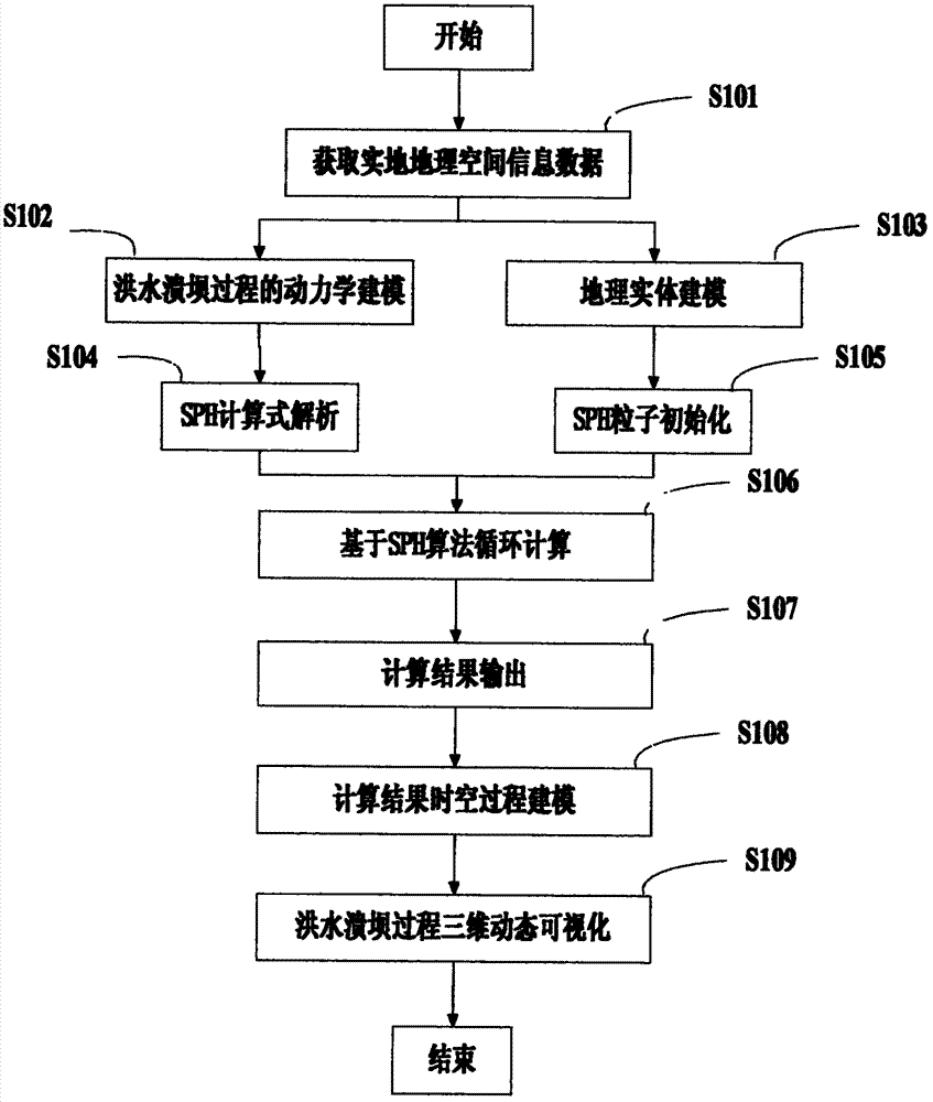
[0068] Such as figure 1 Shown, be the flow chart of the flood dam failure process simulation method based on SPH algorithm in the implementation of the present invention, concrete steps are as follows:

[0069] Step S101 , acquiring real geospatial information data.

[0070] In this embodiment, the on-the-spot geospatial information data includes: satellite imagery, aerial imagery, data elevation model data, digital line drawing and other geographic information data of geographic entities, as well as architectural structures, materials, dimensions, specifications, etc. of geographic entities. Kinetic related information data such as spatial distribution status.

[0071] Step S102, establishing a dynamic model of the flood dam break process based on the geospatial information data acquired in step S101.

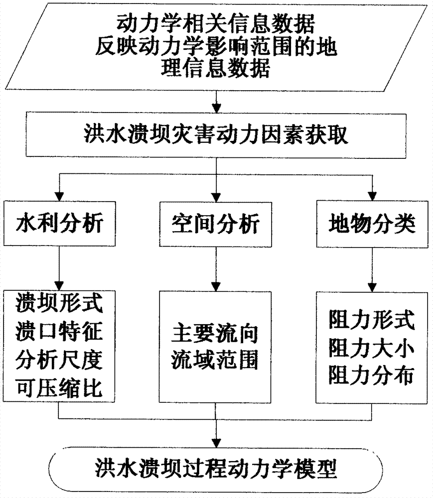
[0072] The specific implementation process is as figure 2 Shown:

[0073] 1) From the dynamic information data such as the building structure, material, size specificatio...

Embodiment 2

[0125] Such as Figure 8 Shown, be the structural block diagram of the flood dam break process simulation system based on SPH algorithm in the implementation of the present invention, this simulation system comprises:

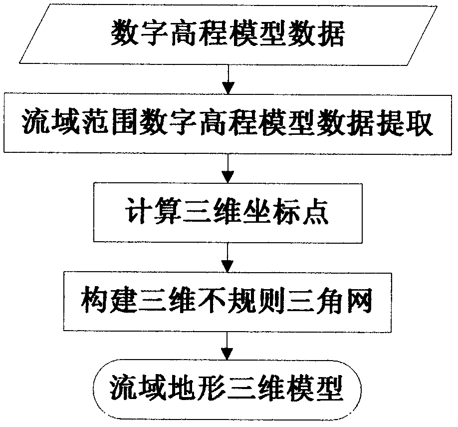
[0126] 1) The geospatial information data preprocessing module is used for coordinate integration of geospatial information data, constructing a dynamic model of flood and dam break process according to the spatial characteristics of geospatial information, constructing a three-dimensional terrain modeling according to digital elevation model data, and water, Construction of 3D models of geographic entities such as dams;

[0127] 2) The SPH calculation module is used for analysis and particle initialization using the SPH algorithm, the realization of the cycle calculation of the SPH algorithm, and the output of the SPH calculation result;

[0128] 3) Spatial-temporal process modeling module, used to interpret the calculation results of SPH, generate, compress ...


PUM


Abstract

The invention provides an SPH (smoothed particle hydrodynamics) algorithm-based simulation method and an SPH (smoothed particle hydrodynamics) algorithm-based simulation system of the process of breaking dam by flood. The simulation method comprises the following steps: A. acquiring on-site geographic spatial information data; B. establishing a dynamical model of the process of breaking dam by flood based on the geographic spatial information data obtained in the step A; C. establishing a geographic entity model according to the geographic spatial information data obtained in the step A; D. analyzing the dynamical model obtained in the step B into an SPH calculation method; E. initializing the geographic entity model obtained in the step C to be hydrodynamics particles and boundary particles for the SPH calculation; F. circularly calculating based on the SPH algorithm; G. carrying out the spatial-temporal process modeling on the calculated value result obtained in the step F to obtain a 3D spatial-temporal model and a database of the process of breaking the dam by flood; and H. dynamically visualizing the 3D spatial-temporal model and the database of the process of breaking dam by flood obtained in the step G. By using the SPH method in the geographic process simulation, the authenticity of the simulation result is effectively improved.

Description

technical field [0001] The invention belongs to the technical field of geoscience process simulation and geographic information system, and in particular relates to a flood dam break process simulation method and simulation system based on SPH (Smoothed Particle Hydrodynamics, smooth particle hydrodynamics) algorithm. Background technique [0002] In recent years, geological disasters have occurred frequently in the world. The simulation of the geological process of disasters like floods and dam failures, which integrates multiple disciplines such as geosciences, computer graphics, simulation calculations, physics, and mathematics, is currently a research hotspot and difficulty. [0003] In the field of geographic information systems, the traditional simulation method is realized by using empirical formula models such as geoscience models or mathematical models, that is, by analyzing the main influencing factors of the flood dam break process, such as slope and confluence, et...

Claims


Application Information

Patent Timeline
IPC IPC(8): G06F17/50G06F17/30
CPCY02A10/40
Inventor 唐新明汪汇兵欧阳斯达李忠叶芳宏
Owner 自然资源部国土卫星遥感应用中心
Why Eureka
Try Eureka