GPS leveling height transfer method

A GPS leveling and elevation technology, applied in altitude/level measurement, measuring devices, instruments, etc., can solve problems such as difficult to solve, inability to accurately solve orthometric heights, and inability to achieve second-class level transmission accuracy, achieving a wide range of applications and high precision. high effect

Active Publication Date: 2013-01-30
CHINESE ACAD OF SURVEYING & MAPPING
View PDF3 Cites 0 Cited by
  • Summary
  • Abstract
  • Description
  • Claims
  • Application Information

AI Technical Summary

Problems solved by technology

Physical quantities such as the geoid and the orthometric system under the Stokes theory have strict physical meanings, but there are also the following basic shortcomings: 1) the orthometric height cannot be accurately calculated; 2) the solution needs to know the actual gravity on the geoid , so gravity reduction is required, and the crustal density and terrain quality need to be estimated; 3) The geoid is used as the boundary surface, which belongs to the free boundary problem and is not easy to solve
The above method is applied to road construction in mountainous areas, large-scale surveying, and cross-sea elevation transfer, etc., can achieve fourth-class level elevation transfer accuracy, and some areas can reach third-class elevation transfer accuracy, but still cannot achieve second-class leveling accuracy that can replace conventional leveling surveys. Level transmission accuracy

Method used


Image

  • GPS leveling height transfer method
  • GPS leveling height transfer method
  • GPS leveling height transfer method

Examples


Embodiment Construction

[0034] The GPS level elevation transfer method proposed by the present invention is described as follows in conjunction with the accompanying drawings and embodiments.

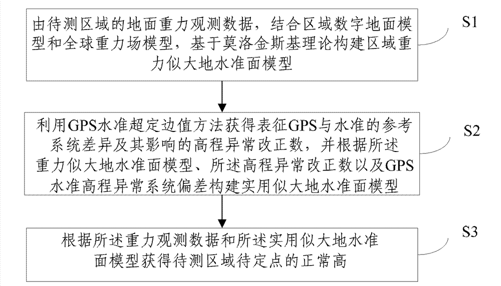
[0035] Such as figure 1 As shown, the GPS level elevation transmission method of the present invention comprises the following steps S1-3:

[0036] S1: According to the ground gravity observation data of the area to be measured, combined with the regional digital ground model DTM and the global gravity field model EGM, the regional gravity quasi-geoid model is constructed based on the Molodinsky theory;

[0037] The purpose of this step is to realize the solution of the gravity quasi-geoid model based on Molodensky theory. The data sources for model calculation include: gravity observation data of discrete points in the area to be measured (accuracy better than 60 milligal), global gravity field model (EGM), and regional digital terrain model (DTM).

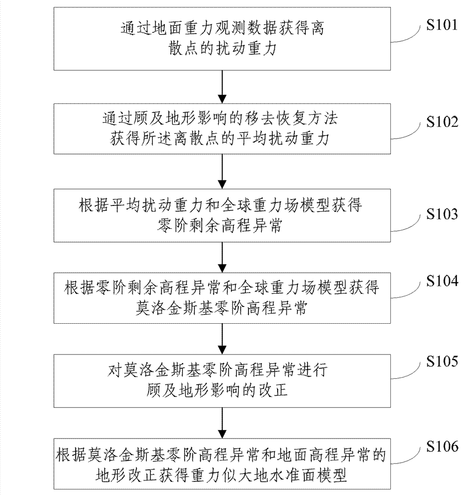
[0038] Specifically, as figure 2 As shown, the gravity...


PUM


Abstract

The invention provides a GPS leveling height transfer method, which comprises the following steps of: S1: creating a regional gravity quasigeoid model based on the Molodensky theory according to ground gravity observation data by combining with a regional digital terrain model and a global gravity field model; S2, obtaining a reference system difference between a GPS geodetic height and a leveling height and a height anomaly correction term influenced by the reference system difference through a GPS leveling overdetermined boundary value method, and creating a practical quasigeoid model according to the gravity quasigeoid model, the height anomaly correction term and the preset GPS leveling height anomaly system deviation; S3, obtaining a normal height of a pointed to be measured of a region to be measured according to the gravity observation data and the practical quasigeoid model. The method can implement that the GPS leveling replaces a trigonometric leveling or a conventional leveling to meet the transfer accuracy of a two-stage leveling height difference.

Description

technical field [0001] The invention relates to the technical field of geodetic surveying applications, in particular to a GPS level elevation transmission method. Background technique [0002] Stokes theory is the basic theory of physical geodesy. It takes the geoid as the boundary surface, assumes that there is no mass outside the geoid, and forms the third boundary value problem based on the basic differential equation of gravity measurement on the geoid. , used to solve for the perturbation potential and geoid height, thereby determining the physical shape of the Earth. Physical quantities such as the geoid and the orthometric system under the Stokes theory have strict physical meanings, but there are also the following basic shortcomings: 1) the orthometric height cannot be accurately calculated; 2) the solution needs to know the actual gravity on the geoid , so gravity reduction is required, and the crustal density and terrain quality need to be estimated; 3) With the...

Claims


Application Information

Patent Timeline
Patent Type & Authority Patents(China)
IPC IPC(8): G01C5/00G01C9/00
Inventor 丁剑柯宝贵张利明章传银
Owner CHINESE ACAD OF SURVEYING & MAPPING
Why Eureka
Try Eureka