
Snow disaster remote sensing monitoring simulation evaluation method based on disaster reduction small satellite

A technology of remote sensing monitoring and snow disaster, applied in the field of satellite remote sensing, can solve the problem of insufficient snow disaster monitoring of satellite remote sensing data

Inactive Publication Date: 2011-09-21
MIN OF CIVIL AFFAIRS NAT DISASTER REDUCTION CENT
View PDF0 Cites 0 Cited by
  • Summary
  • Abstract
  • Description
  • Claims
  • Application Information

AI Technical Summary

Problems solved by technology

[0005] The purpose of this invention is to provide a snow disaster remote sensing monitoring simulation evaluation method based on disaster reduction small satellites, to solve the problem of insufficient snow disaster monitoring of China's independent satellite remote sensing data

Method used


Image

  • Snow disaster remote sensing monitoring simulation evaluation method based on disaster reduction small satellite
  • Snow disaster remote sensing monitoring simulation evaluation method based on disaster reduction small satellite
  • Snow disaster remote sensing monitoring simulation evaluation method based on disaster reduction small satellite

Examples


Embodiment Construction

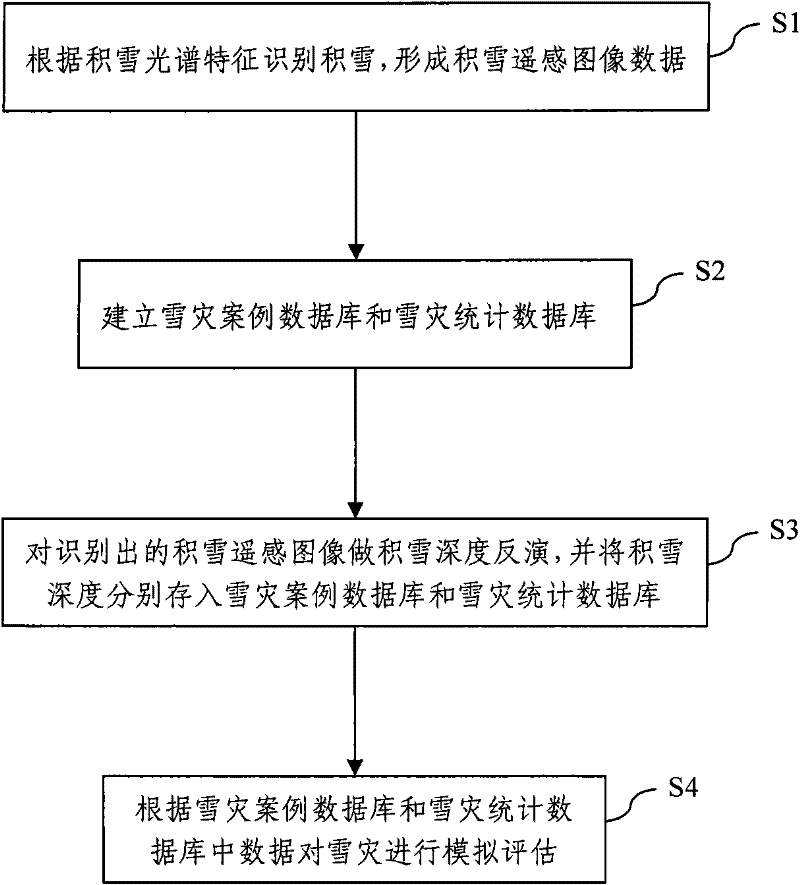
[0058] A snow disaster remote sensing monitoring simulation evaluation method based on a small disaster reduction satellite proposed by the present invention is described as follows in conjunction with the accompanying drawings and embodiments.

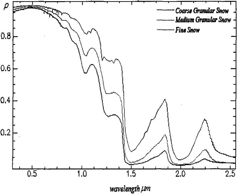
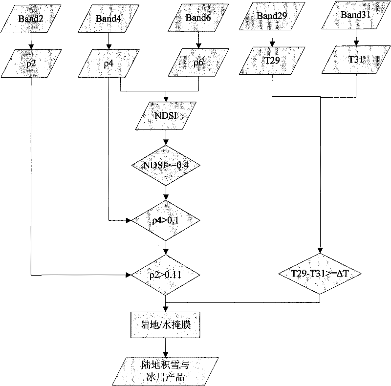
[0059] like figure 1 As shown, in step S1, the snow is identified according to the snow spectral characteristics, and the spectral curve of a typical snow is as follows figure 2 shown. After analysis, the snow shows high reflectivity in the visible light band (0.38μm-0.72μm) and near-infrared band (0.72μm-1.30μm), but in the near-infrared band (1.30μm-3.00μm), especially The reflectivity near the 1.55μm and 2.10μm bands is very low due to the absorption of solar radiation by snow. At the same time, in view of the fact that snow cover extraction is mainly to distinguish information such as clouds and surface objects, it is found through research that the spectra of snow, clouds, and surface objects have the following characteristics, ...


PUM


Abstract

The invention discloses a snow disaster remote sensing monitoring simulation evaluation method based on a disaster reduction small satellite, comprising the following steps: recognize accumulated snow according to the spectral characteristic of the accumulated snow and form accumulated snow remote sensing images data; create a snow disaster case database and a snow disaster statistical database, the snow disaster case database comprises a disaster time, a location hit by the disaster, an accumulated snow day number, a normalized difference vegetation index NDVI, a population number hit by thedisaster and a accumulated snow area, the snow disaster statistical database comprises a total precipitation, a highest air temperature, a lowest air temperature, a average daily temperature, a wind speed and a surface temperature; carry out an accumulated snow depth inversion to a recognized accumulated snow, and respectively store the accumulated snow depth into the snow disaster case database and the snow disaster statistical database; carry out simulation evaluation to a snow disaster according to the data in the snow disaster case database and the snow disaster statistical database. A new and high applicability remote sensing data source is provided for snow disaster monitoring in the invention, and the snow disaster remote sensing monitoring simulation evaluation method has a great importance of disaster reduction and disaster relief works for China snow disaster.

Description

technical field [0001] The invention relates to the technical field of satellite remote sensing, in particular to a snow disaster remote sensing monitoring simulation evaluation method based on a small disaster reduction satellite. Background technique [0002] China is one of the few space powers in the world, but there are many problems in remote sensing of snow disasters. On the one hand, a large amount of remote sensing data needs to be imported from abroad, which is not only expensive and difficult to obtain in real time, but also foreign data cannot meet the actual needs of China's snow disaster management in many aspects. On the other hand, the application of China's independent satellite remote sensing data in snow disaster management is not extensive and deep enough, and it is urgent to intensify research efforts. There is an urgent need for the satellites that China has launched and the environment and disaster small satellite constellation launched in 2007. fix i...

Claims


Application Information

Patent Timeline
Patent Type & Authority Patents(China)
IPC IPC(8): G01W1/00G01S17/00
Inventor 杨思全范一大聂娟吴玮刘三超刘龙飞
Owner MIN OF CIVIL AFFAIRS NAT DISASTER REDUCTION CENT
Learn More