
Geospatial inconsistencies identification data system based on contractual rights and geographical network analysis

a data system and geographical network technology, applied in the field of data systems, can solve problems such as ineffective current procedures for identifying the misrepresentation or misappropriation of contractual rights (e.g., licenses, permits, grants, etc., to reduce the recoupment of improperly made payments, and the difficulty of assessing fraudulent intentions for submitted and existing contractual rights applications

Inactive Publication Date: 2012-06-28
DSCS LLC
View PDF4 Cites 13 Cited by
  • Summary
  • Abstract
  • Description
  • Claims
  • Application Information

AI Technical Summary

Benefits of technology

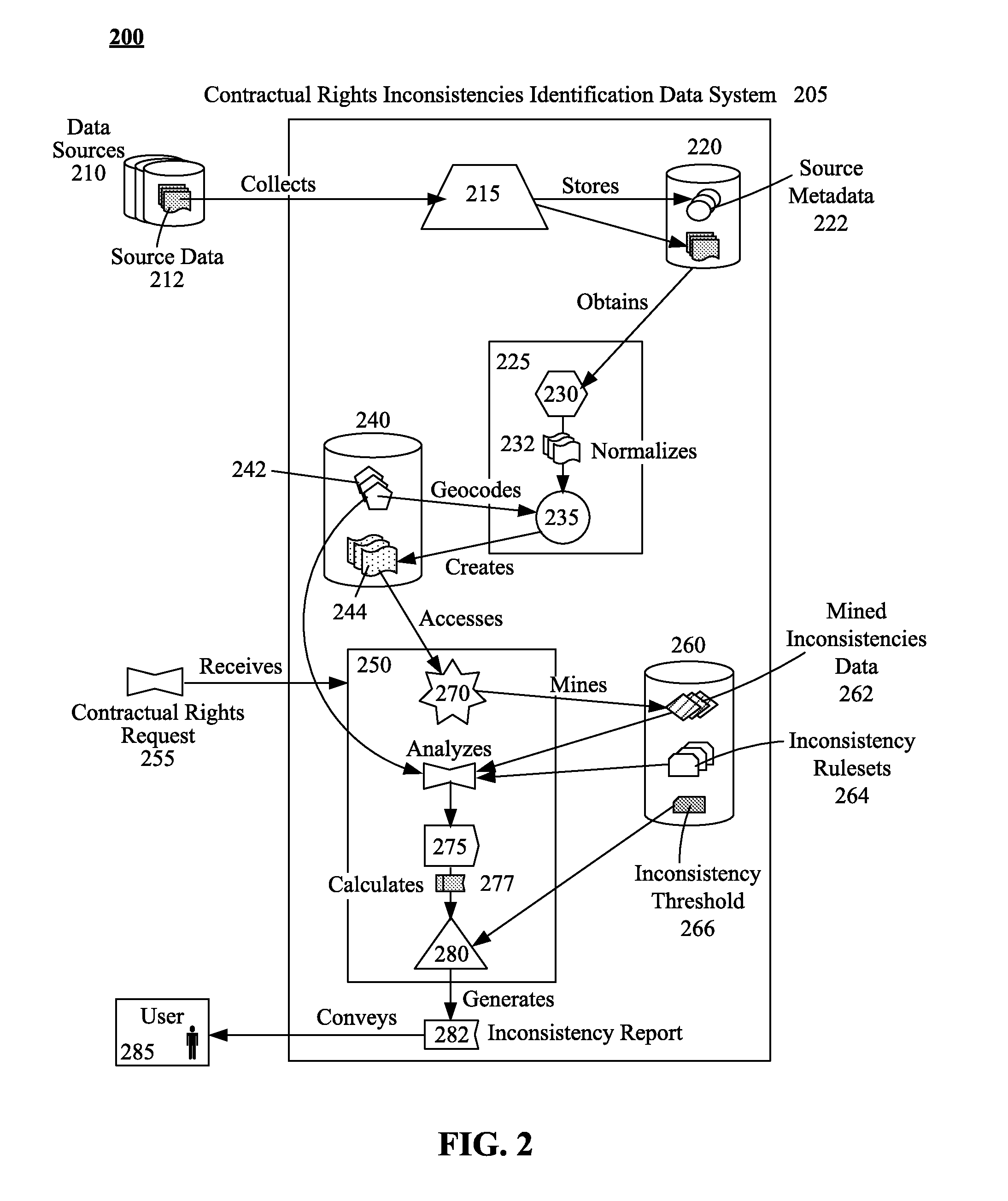
[0008]The disclosure can be performed in accordance with numerous aspects and embodiments detailed herein. One aspect can include a method, a computer program product, a system, and a device for detecting geospatial inconsistencies for requested and / or existing contractual rights. In the aspect, an application document for a contractual right can be identified. The contractual right can define a compensatory relationship between two entities for specified conditions. At least one address can be determined from the application document, renewal application, or list of current grantees, where activities related to the contractual right are to be performed or are currently being performed. The address can be converted into geospatial coordinates. A database of geospatially recorded items can be queried for activities proximate to the geospatial coordinates. A geospatial inconsistency score can be generated based on the results from the database and their level of incompatibility with conducting the activity for which the contractual right is sought or is currently granted. When the geospatial inconsistency score is less than or equal to a previously established threshold, an indication can be provided that no problem has been detected that indicates that the contractual right should not be granted, renewed or continued. When the geospatial inconsistency score exceeds a previously established threshold, an indication can be provided indicating that a problem has been detected that indicates that further analysis should be conducted before the contractual right is granted, renewed, or continued.

Problems solved by technology

Backlogs and the sheer volume of applications have rendered current procedures for identifying the misrepresentation or misappropriation of contractual rights (e.g., licenses, permits, grants, policies, entitlement to benefits, etc.) ineffective.
This physical and / or political dissociation in data has created an environment where it is difficult to assess fraudulent intentions for submitted and for existing contractual rights applications.
While most private and public agencies / organizations have procedures in place for identifying such fraudulent activities, determinations by these procedures are often belated, decreasing the recoupment of improperly made payments.
Many valid mailing addresses exist in areas unsuitable or unable to support the business and / or other activities associated with certain contractual rights.
However, a cemetery is not a suitable place to be used as a mailing address when requesting or renewing a contractual right like a healthcare provider license or daycare provider license.

Method used


Image

  • Geospatial inconsistencies identification data system based on contractual rights and geographical network analysis
  • Geospatial inconsistencies identification data system based on contractual rights and geographical network analysis
  • Geospatial inconsistencies identification data system based on contractual rights and geographical network analysis

Examples


Embodiment Construction

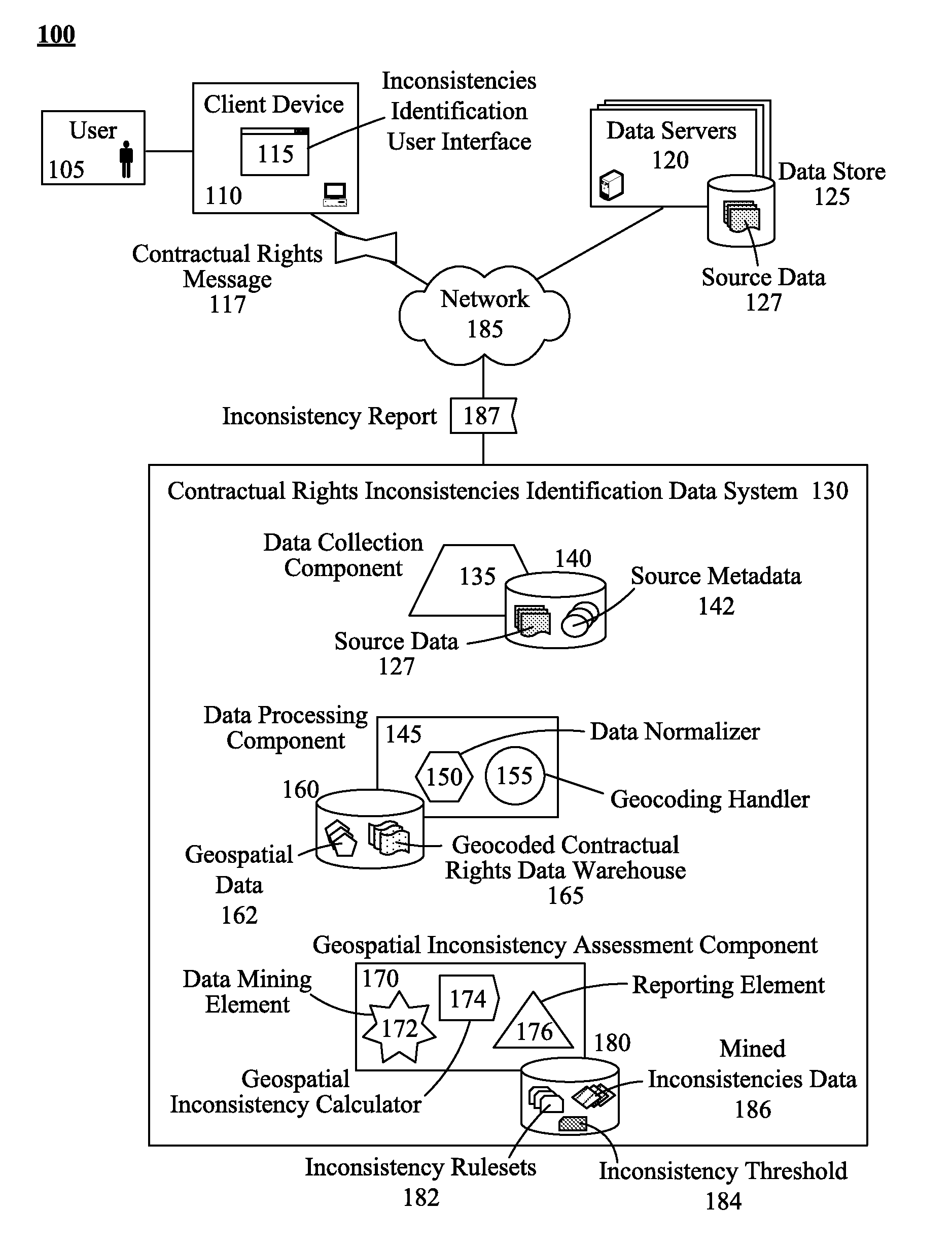
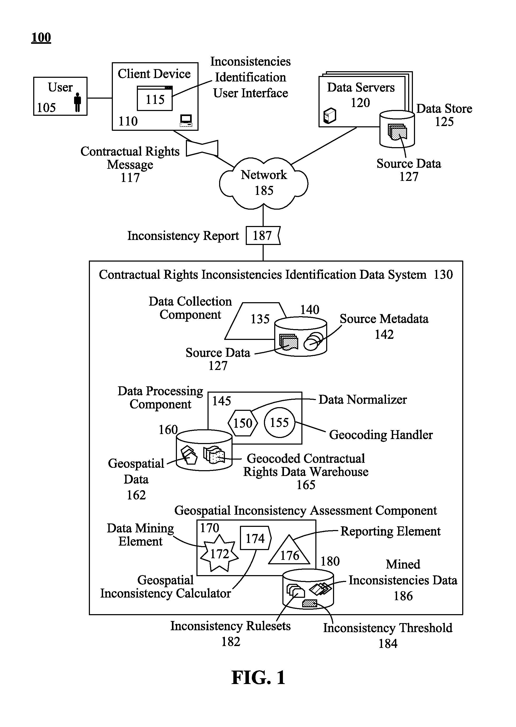
[0018]The present invention discloses a solution for identifying inconsistencies contained in contractual rights applications indicating potential fraudulent submissions prior to approval, renewal, or continuation of the contractual rights applications. A contractual rights inconsistencies identification data system can be used to generate a geocoded contractual rights data warehouse from a variety of disparate data sources. In one embodiment these disparate data sources can consist entirely of open source information repositories. These open source repositories can indicate a likelihood of incompatible purposes for a set of stated addresses. For example, if a mailing address is within the defined geographical boundaries of a cemetery, it would not be possible (or at least highly unlikely) that a valid healthcare-related business is being conducted from that address. Historical address checks have yielded only whether an address was a valid postal address and have not compared the c...


PUM


Abstract

An application document for a contractual right can be identified. The application document can be a new application seeking a contractural right or an existing one for which a contractual right has already been granted yet which is being verified herein. The contractual right can define a compensatory relationship between two entities for specified conditions. At least one address can be determined from the application document, where activities related to the contractual right are to be performed. The address can be converted into geospatial coordinates. A database of geospatially recorded items can be queried for activities proximate to the geospatial coordinates. A geospatial inconsistency score can be generated based on the results from the database and their level of incompatibility with conducting the activity for which the contractual right is related.

Description

BACKGROUND[0001]The present invention relates to the field of data systems and, more particularly, to a geospatial inconsistencies identification data system based on contractual rights and geographical network analysis.[0002]Backlogs and the sheer volume of applications have rendered current procedures for identifying the misrepresentation or misappropriation of contractual rights (e.g., licenses, permits, grants, policies, entitlement to benefits, etc.) ineffective. Issuing agencies and organizations for contractual rights exist for a variety of services (e.g., health / life / fire / auto / property insurances, benefit disbursements) and at varying levels of government (e.g., federal, state, and local) as well as within the private and non-profit sectors. Each agency / organization maintains a collection of application data submitted for contractual rights consideration.[0003]Many of the data items collected from a contractual rights application for one type of right or by one type of agenc...

Claims


Application Information

Patent Timeline
Patent Type & Authority Applications(United States)
IPC IPC(8): G06Q99/00
CPCG06Q10/10G06Q50/18G06Q30/02G06Q30/018
Inventor LACAL, JOSE
Owner DSCS LLC
Learn More