Processing time-based geospatial data

a geospatial data and time-based technology, applied in the field of geospatial data processing, can solve problems such as users' questioning the reliability of geolocation services, maps with obvious errors, and failure to show buildings

Active Publication Date: 2011-06-16
GEOSEMBLE TECH +1
View PDF14 Cites 50 Cited by
  • Summary
  • Abstract
  • Description
  • Claims
  • Application Information

AI Technical Summary

Problems solved by technology

Unfortunately, association of geospatial datasets with geospatial imagery without regard to the synchronicity between the geospatial datasets and the geospatial imagery may lead to maps with obvious errors.
For example, temporally newer geospatial vector data such as latitude and longitude coordinates corresponding to the location of a building may be erroneously combined with older geospatial imagery that, while showing the same latitude and longitude coordinates, fail to show the building because the building was not built at the time the geospatial image was captured.
Deleterious geolocation errors such as these require independent verification of the actual location of the building and may cause users to question the reliability of the geolocation services.

Method used


Image

  • Processing time-based geospatial data
  • Processing time-based geospatial data
  • Processing time-based geospatial data

Examples


Embodiment Construction

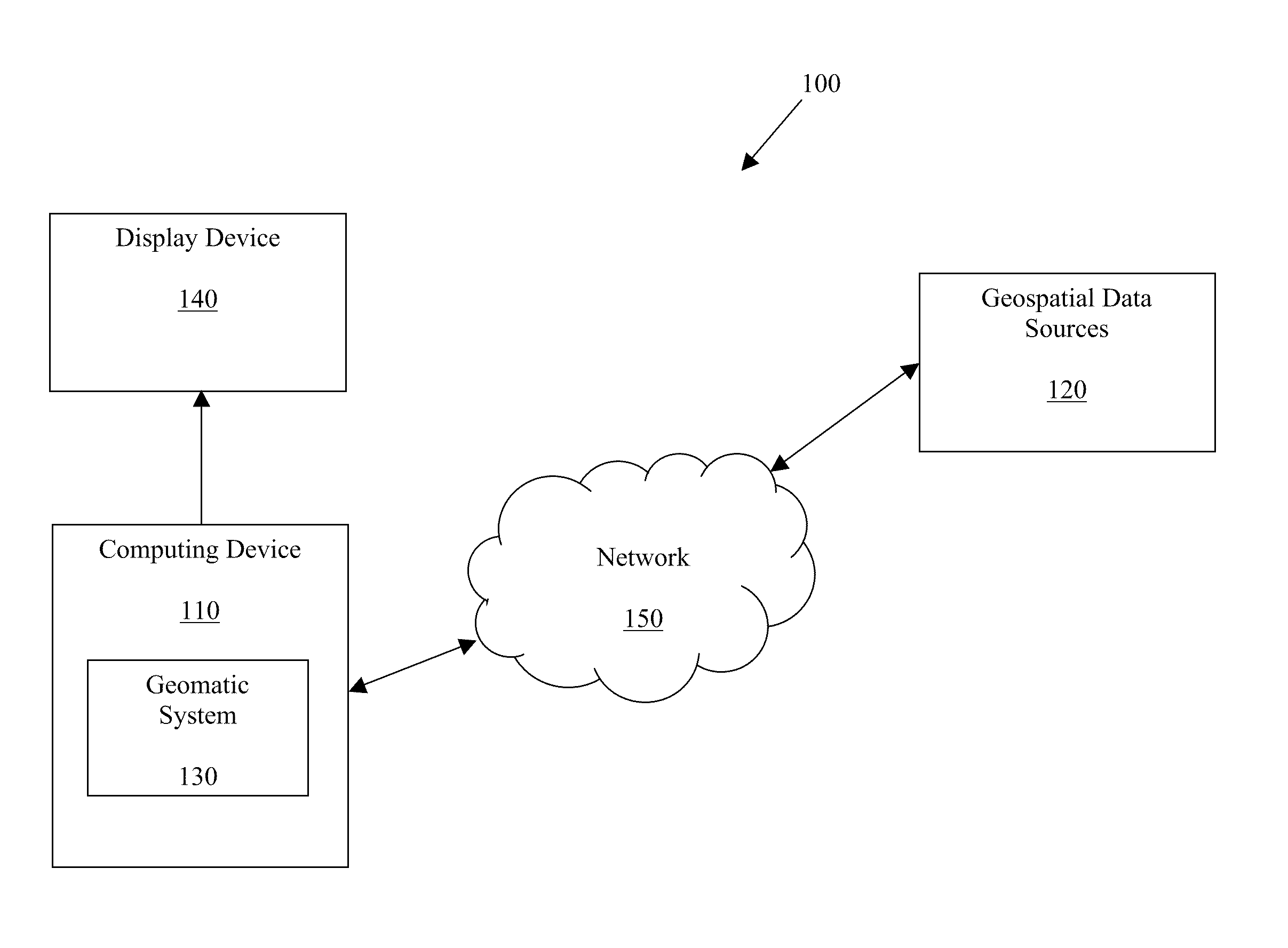
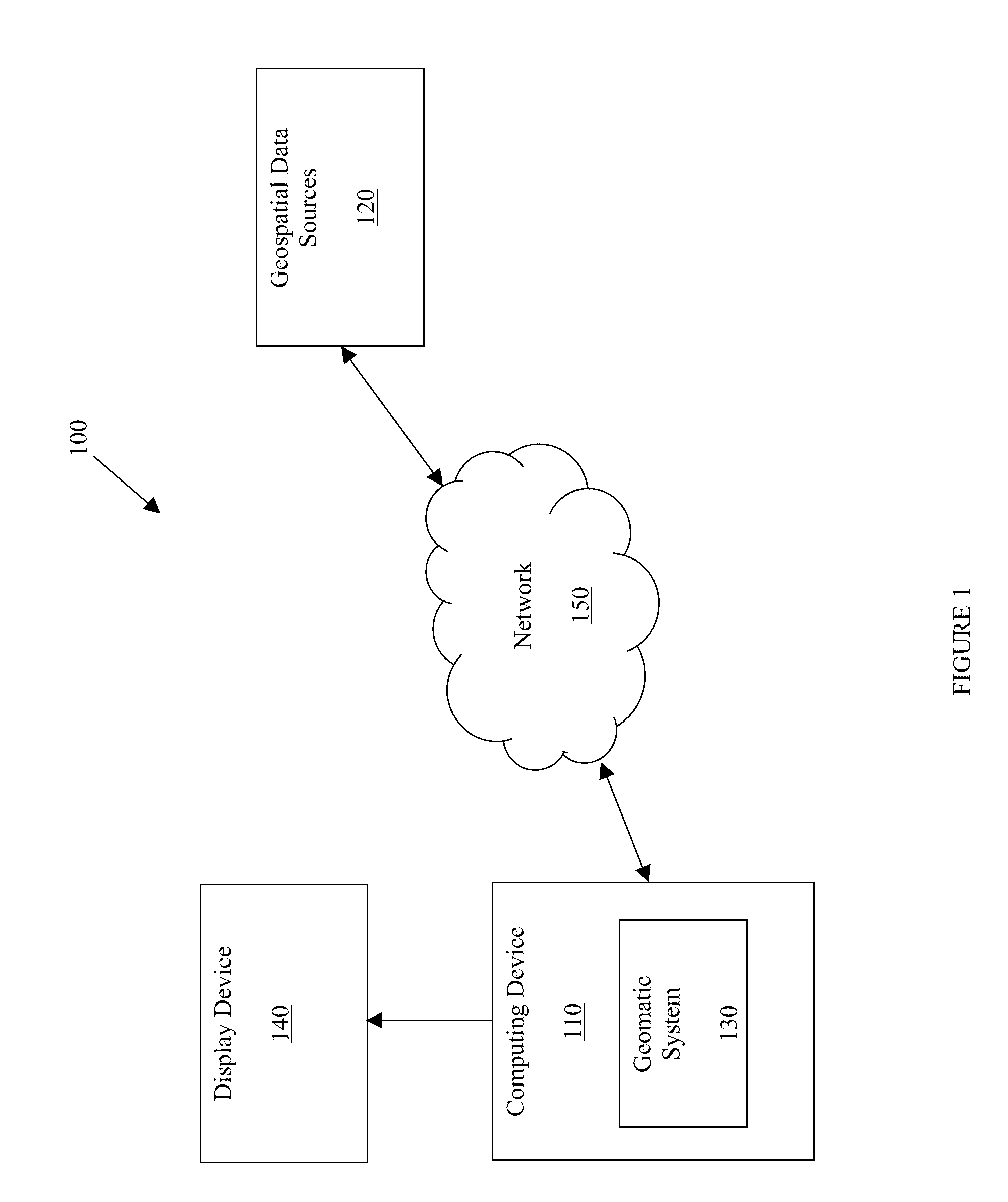
[0022]Referring now to FIG. 1, a block diagram of an exemplary environment 100 for practicing embodiments of the present technology is shown. The environment 100 includes a computing device 110 and geospatial data sources 120. Computing device 110 includes geomatic system 130 that may be connected to display device 140 and may communicate with geospatial data sources 120. The geomatic system 130 is discussed in further detail in connection with FIG. 2. Other various components (not shown) that are not necessary for describing the present technology may also be included in the environment 100, in accordance with exemplary embodiments. Examples of the computing device 110 may be a desktop personal computer (PC), a laptop PC, a pocket PC, a personal digital assistant (PDA), a smart phone, a cellular phone, a global positioning system (GPS) device, and so on. Computing device 110 is discussed in more detail with respect to FIG. 10.

[0023]The geospatial data sources 120 may comprise any r...


PUM


Abstract

A method for processing geospatial datasets corresponding to geospatial objects, the method having the steps of extracting geospatial attributes from the geospatial datasets, locating extracted geospatial attributes corresponding to a particular geospatial object at a particular point in time, and generating output indicative of the particular geospatial object at the particular point in time utilizing the located geospatial attributes.

Description

CROSS-REFERENCE TO RELATED APPLICATION[0001]This application is a Continuation-in-part and claims the priority benefit of U.S. patent application Ser. No. 12 / 501,242, entitled “Precisely Locating Features on Geospatial Imagery,” filed on Jul. 10, 2009, the disclosure of which is incorporated herein by reference.BACKGROUND OF THE INVENTION[0002]1. Field of the Invention[0003]The present invention relates generally to processing geospatial data, and more specifically, but not by way of limitation, to extracting geospatial attributes from geospatial datasets representing a particular geospatial object[0004]2. Related Art[0005]In general geospatial objects may be represented by geospatial datasets. Additionally, geospatial datasets may be broadly categorized into structured and non-structured types of geospatial datasets. Structured geospatial datasets include, but are not limited to, non-structured geospatial images and geospatial vector data. Geospatial images are images of the Earth'...

Claims


Application Information

Patent Timeline
Patent Type & Authority Applications(United States)
IPC IPC(8): G06K9/46
CPCG06F17/30241G06F16/29
Inventor CHEN, CHING-CHIENKNOBLOCK, CRAIG A.SHAHABI, CYRUS
Owner GEOSEMBLE TECH
Why Eureka
Try Eureka