
Navigation device and approach information display method

A navigation device and a technology for identifying information, which is applied to the arrangement of variable traffic instructions, instruments, traffic control systems, etc., can solve the problems of local areas, places that cannot be used in places with poor vision, and high cost, so as to reduce the burden and avoid the risk of collision Sexuality, the effect of suppressing the initial cost

Inactive Publication Date: 2006-01-18
PANASONIC CORP
View PDF1 Cites 28 Cited by
  • Summary
  • Abstract
  • Description
  • Claims
  • Application Information

AI Technical Summary

Problems solved by technology

[0004] Such detection of oncoming vehicles can be performed using microwave radar, for example, but in a system using microwave radar, it can only be judged at a short distance of about tens of meters
In addition, there is a problem that by installing roadside wireless devices on roads, it is possible to notify traveling vehicles of oncoming vehicle information through road-to-vehicle communication, but such a system is costly and the area is localized
In addition, it is also possible to use a camera to take pictures, but if the detection system of the camera is used, it cannot be used in places with poor visibility, etc.

Method used

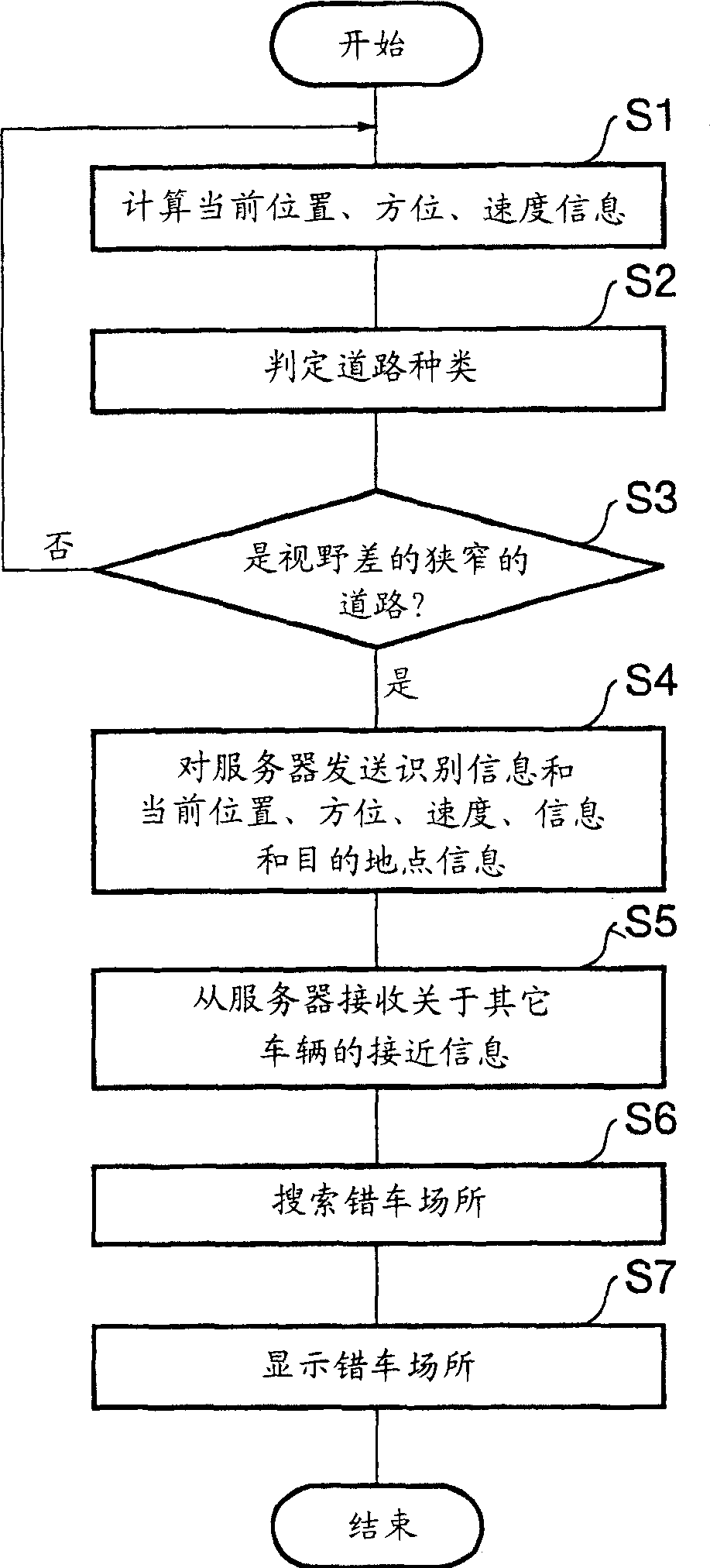

Image

  • Navigation device and approach information display method
  • Navigation device and approach information display method
  • Navigation device and approach information display method

Examples


Embodiment approach 1

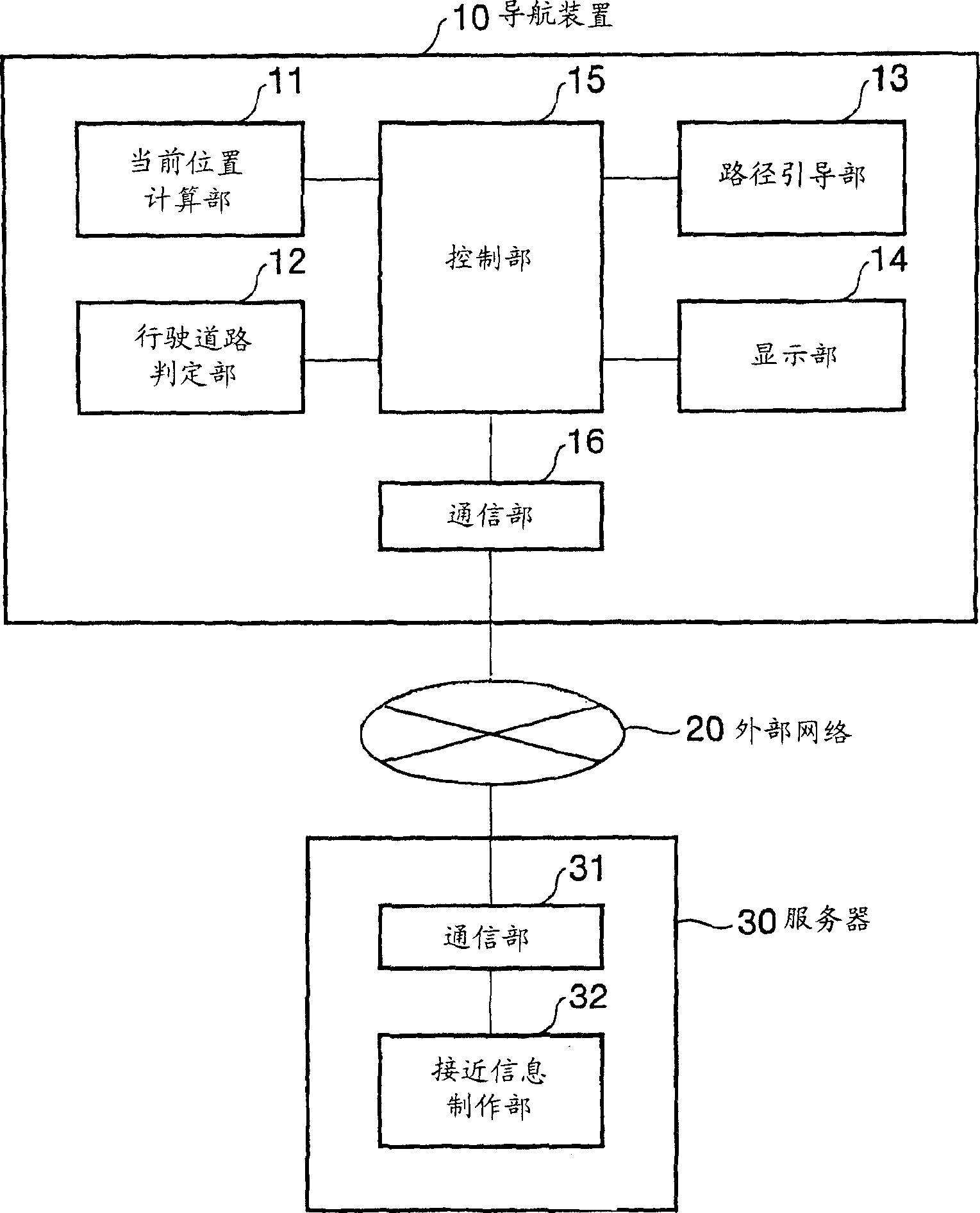
[0032] figure 1 A schematic configuration of a navigation device according to the first embodiment of the present invention is shown. In the navigation device 10 , the current position calculation unit 11 calculates the current position, speed, and orientation of the vehicle by means of a GPS receiver, a vehicle speed sensor, an angular velocity gyroscope, and a map map of a map database. The traveling road judging unit 12 judges the current traveling road based on the GPS positioning result and the road type, road width, connection angle of a plurality of road connections, the number of intersections, the curvature or elevation data of the curve, and the traveling trajectory, etc. Specifically, whether it is a mountainous road, whether it is a road with poor visibility, or whether it is a poor-condition road with poor visibility and narrowness. The route guidance unit 13 searches for a guidance route up to the destination set by the user, and at the same time extracts place...

Embodiment approach 2

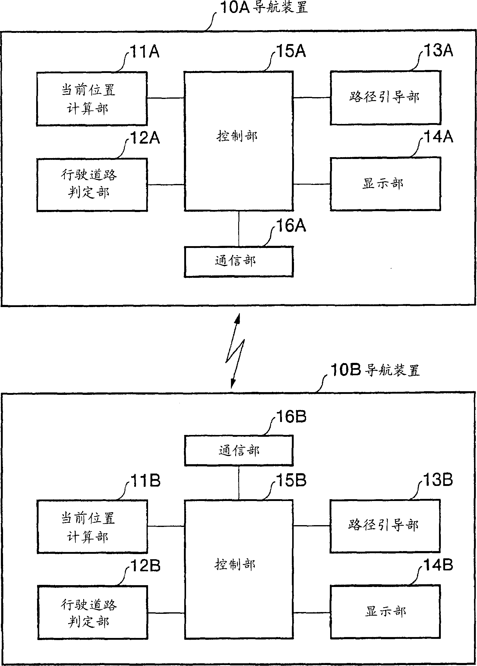
[0039] Next, a second embodiment of the present invention will be described. In the navigation device in the second embodiment of the present invention, such as image 3 As shown, the navigation devices 10A and 10B directly communicate with each other to obtain proximity information. The structure of the navigation devices 10A and 10B and figure 1 The navigation device 10 is substantially the same, but the respective communication units 16A, 16B are, for example, wireless devices having a communication area with a radius of about 2.5 km, and other structures are the same as figure 1 Likewise, redundant description of the structure is omitted, and only the operation will be described below.

[0040] Figure 4 It is a flowchart explaining the operation of the second embodiment. Here, a case will be described in which the navigation device 10A transmits the position information to the navigation device 10B which is another device, and the navigation device 10B creates proxim...


PUM


Abstract

By utilizing an existing device, the initial cost is reduced. A blind curve and a narrow road such as a mountain road having a high possibility of danger of collision are detected in advance and the danger of collision is evaded in advance. For this, a current position calculation section calculates the current position, the direction, and the speed. When a running road judgment section judges that the currently running road is a blind narrow curve such as a mountain road, it transmits identification information for identifying the local device and the current position information to an external server via communication means. According to the approach information on the oncoming car or the following car too near received from the server, a route guiding section searches a place where passing each other is possible and displays it on a display section. It should be noted that navigation devices can exchange information directly with each other.

Description

technical field [0001] The present invention relates to a navigation device capable of notifying a user of approach information of other vehicles and a method of displaying approach information. Background technique [0002] Conventionally, a navigation device mounted on a mobile body such as a vehicle has as a basic function the function of finding the position of the mobile body using a positioning system such as GPS and displaying the position of the mobile body on a map displayed on a monitor based on road map data. In addition, it also includes a function to search for a driving route to a destination and provide guidance, to provide guidance on the direction of travel at an intersection, or to search for and provide guidance on facilities along the way. Furthermore, recently, a navigation device has been proposed with an added function of transmitting from a central station the individual information suitable for each vehicle in places where there are many accidents su...

Claims


Application Information

Patent Timeline
Patent Type & Authority Applications(China)
IPC IPC(8): G08G1/16G08G1/09
CPCG08G1/161G08G1/16G08G1/166G08G1/0962
Inventor 太田宏树
Owner PANASONIC CORP
Learn More