
Traffic accident space-time influence range estimation method considering multiple congestion levels

A traffic accident and impact range technology, applied in the field of traffic accident management, can solve the problem of low accuracy and precision in estimating the space-time impact range of traffic accidents

Active Publication Date: 2021-06-08
BEIJING JIAOTONG UNIV
View PDF7 Cites 2 Cited by
  • Summary
  • Abstract
  • Description
  • Claims
  • Application Information

AI Technical Summary

Problems solved by technology

The disadvantage of this method is: this method can only distinguish two levels of congestion and non-congestion, and the estimation accuracy and precision of the space-time influence range of traffic accidents are not high

Method used


Image

  • Traffic accident space-time influence range estimation method considering multiple congestion levels
  • Traffic accident space-time influence range estimation method considering multiple congestion levels
  • Traffic accident space-time influence range estimation method considering multiple congestion levels

Examples


Embodiment

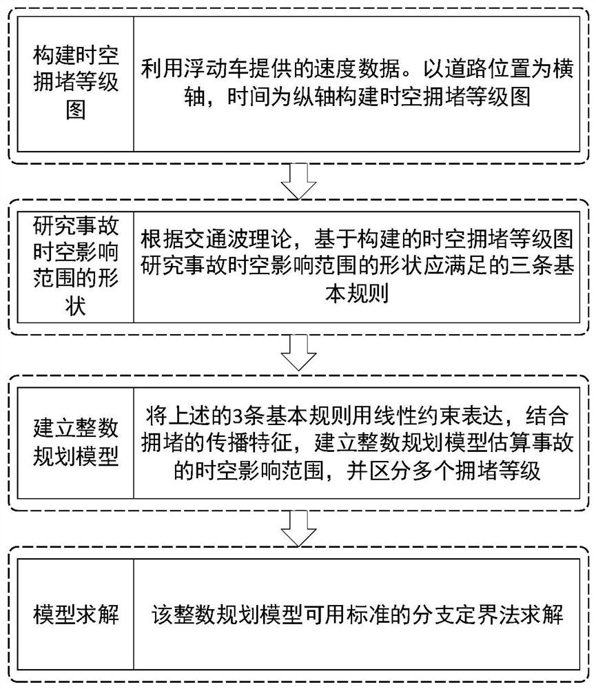
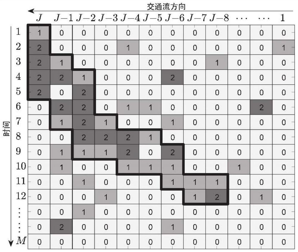
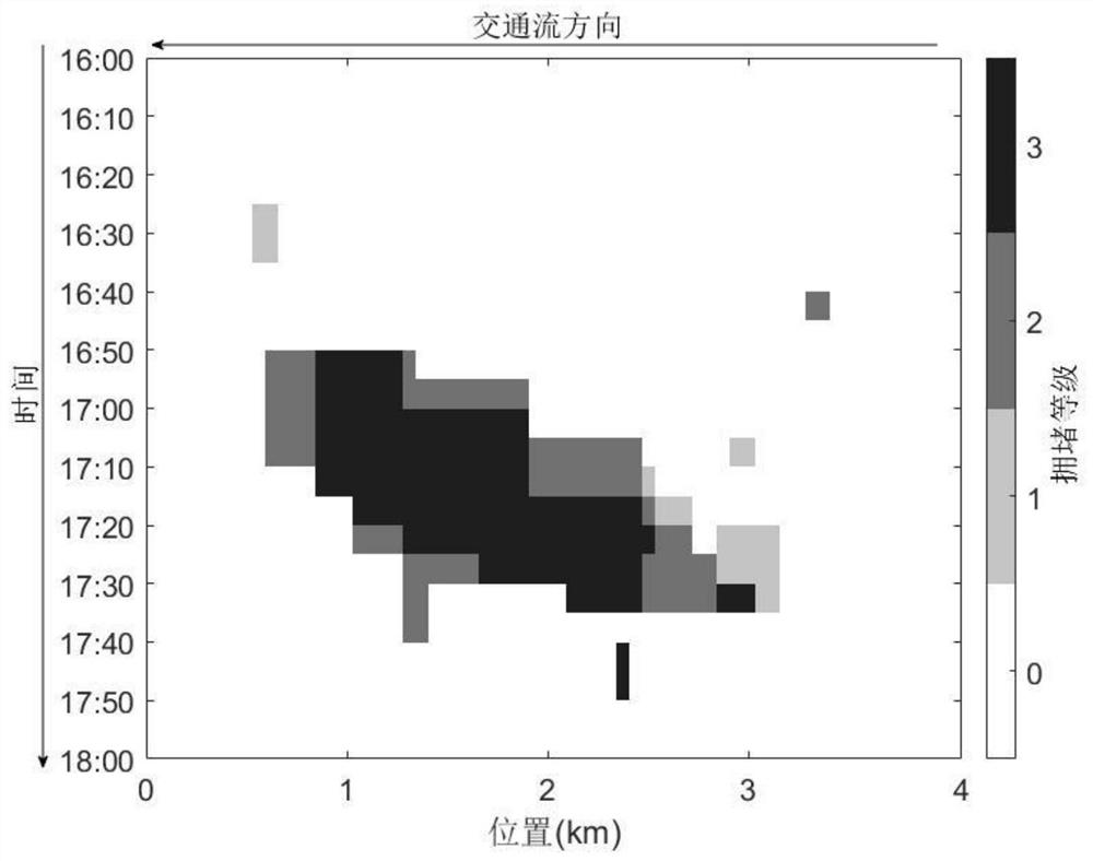
[0147] In this example, an integer programming optimization model considering multiple congestion levels is used to estimate the spatio-temporal scope of accidents. First, use the real speed data provided by the floating car to construct the road spatio-temporal congestion level map for the accident instance that occurred on the North Third Ring Road in Beijing, and then establish the corresponding integer programming optimization model according to the rules of the shape of the accident spatio-temporal influence range, and finally use Python Call the Gurobi solver to solve the model, and get the space-time impact range of the accident and the specific congestion level. Specific steps are as follows:

[0148] Step 1 Use the speed data provided by the floating car to construct a spatio-temporal congestion level map

[0149] Step 1.1 In this example, the speed data of the floating car is used to construct the spatio-temporal congestion level map of the road. Firstly, the studi...


PUM


Abstract

The invention provides a traffic accident space-time influence range estimation method considering multiple congestion levels. The method comprises the following steps: constructing a space-time congestion level map by using speed data provided by a floating car, respectively obtaining speeds sj, m at a road section j and a time interval m under the condition of no accident and after the accident, and calculating a congestion level of each space-time cell according to the speeds and the speeds sj, m based on the number of congestion levels, a basic rule which should be met by the shape of a space-time area influenced by an accident is set according to a traffic wave propagation rule, and establishing an integer programming optimization model of a traffic accident influence range according to the basic rule, a constraint condition and an objective function, and solving the integer programming optimization model to obtain the optimized congestion level of each space-time cell. According to the method, a plurality of congestion levels can be distinguished, and the accuracy and precision of estimation are improved. The estimation result meets the propagation law of traffic waves, and the reasonability of the estimated space-time influence range is ensured.

Description

technical field [0001] The invention relates to the technical field of traffic accident management, in particular to a method for estimating the spatio-temporal influence range of traffic accidents considering multiple congestion levels. Background technique [0002] Sudden traffic accidents on the road will hinder the normal driving of vehicles and reduce the operating efficiency of the road system, which will bring inconvenience to people's travel. Because the time and location of traffic accidents are relatively random, there are often no rules to follow. If they are not evacuated in time, it may cause serious traffic congestion, or even local traffic paralysis. Estimating the spatio-temporal influence range caused by traffic accidents can provide guidance for traffic emergency handling. It can not only be used to quantify vehicle delays caused by accidents, but also can be used to determine the maximum congestion duration and the farthest congestion distance caused by ac...

Claims


Application Information

Patent Timeline
Patent Type & Authority Applications(China)
IPC IPC(8): G08G1/01G06Q10/04G06Q50/26
CPCG08G1/0125G06Q10/04G06Q50/26
Inventor 王正礼郑振杰陈哲
Owner BEIJING JIAOTONG UNIV
Learn More