
Map editor, map engine, map editing system, method and storage medium

A map engine and editor technology, applied in the field of geographic information, can solve the problem that the map cannot meet all the needs of meteorological applications, and achieve the effect of personalized editing, convenient use and operation

Active Publication Date: 2021-05-25
北京简巨科技有限公司
View PDF0 Cites 0 Cited by
  • Summary
  • Abstract
  • Description
  • Claims
  • Application Information

AI Technical Summary

Problems solved by technology

And the demand for this "specific geographical range" is random and varies depending on the actual scene. It may also be a geographical range of 2 kilometers around a certain river or road, or it may be a research area manually drawn on the map. the geographic scope of the rule, etc.
Therefore, it is difficult to meet all the needs in meteorological applications with pre-made maps

Method used


Image

  • Map editor, map engine, map editing system, method and storage medium
  • Map editor, map engine, map editing system, method and storage medium
  • Map editor, map engine, map editing system, method and storage medium

Examples


Embodiment Construction

[0069] In order to make the purpose, technical solutions and advantages of the present disclosure clearer, the present disclosure will be further described in detail below in conjunction with specific embodiments and with reference to the accompanying drawings.

[0070] It should be noted that, unless otherwise defined, the technical terms or scientific terms used in one or more embodiments of the present specification shall have ordinary meanings understood by those skilled in the art to which the present disclosure belongs. "First", "second" and similar words used in one or more embodiments of the present specification do not indicate any order, quantity or importance, but are only used to distinguish different components. "Comprising" or "comprising" and similar words mean that the elements or items appearing before the word include the elements or items listed after the word and their equivalents, without excluding other elements or items. Words such as "connected" or "con...


PUM


Abstract

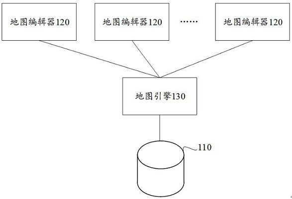
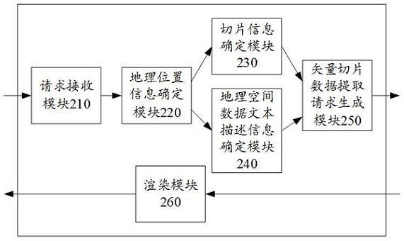
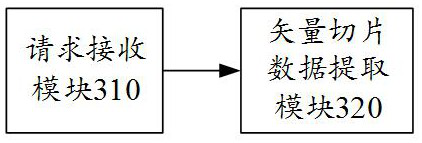
This specification provides a map editing system, including a geospatial database, at least one map editor and a map engine. The above-mentioned map editing system can determine the vector slice information and geospatial data text description information corresponding to the map to be created according to the area information provided by the user, and extract the vector slice information and geospatial data text description information corresponding to the above-mentioned vector slice information and geospatial data text description information from the geospatial data. Vector tile data. After rendering the above vector slice data, a map corresponding to the map area provided by the user can be obtained, so that any area can be supported as the display range of the map. The specification also provides a map editor, a map engine, a map editing method, an electronic device, and a computer-readable storage medium.

Description

technical field [0001] One or more embodiments of this specification relate to geographic information technology, and in particular to a map editor, a map engine, a map editing system, a map editing method, and a computer-readable storage medium. Background technique [0002] An electronic map is a set of software or services that provides data storage, slice generation and rendering of map elements, and usually provides map services in the form of standard Web service interfaces. The application side realizes the loading of map slices by calling the Web service interface. [0003] Existing electronic maps can well meet the requirements for maps in general applications, but there are higher requirements for maps in some special scenarios. For example, in meteorological applications, it is necessary to specify a "specific geographical range" for the map, such as the Yellow River Basin, Beijing, the Yangtze River Delta, Beijing-Tianjin-Hebei, etc., instead of displaying a glo...

Claims


Application Information

Patent Timeline
Patent Type & Authority Patents(China)
IPC IPC(8): G06F16/29G06T11/60
CPCG06T11/60G06F16/29
Inventor 崔福东洪亮张宝才彭乘风
Owner 北京简巨科技有限公司
Learn More