Method and system for farmland irrigation district area remote sensing extraction

An irrigation area, area technology, applied in the field of agricultural remote sensing, can solve the problems of manpower and material resources, poor timeliness, low efficiency, etc., to achieve the effect of improving accuracy and efficiency

Active Publication Date: 2018-12-07
INST OF REMOTE SENSING & DIGITAL EARTH CHINESE ACADEMY OF SCI +1
View PDF6 Cites 20 Cited by
  • Summary
  • Abstract
  • Description
  • Claims
  • Application Information

AI Technical Summary

Problems solved by technology

[0004] Among them, the time series observation and comparison method of vegetation index in irrigated and non-irrigated areas mainly uses high time series remote sensing images to extract vegetation indices, and identifies whether the irrigated area is irrigated or not by comparing the growth period curves corresponding to the crops that grow normally in the irrigated area. The problem of this method is the growth The period curve is affected by factors such as precipitation, temperature, crop species, and growth period, which brings great uncertainty; the Ts-NDVI feature space analysis method has a clear physiological mechanism, but this method needs to know the soil moisture value of the irrigation area, and the model It is also affected by complex factors such as temperature, which will bring certain uncertainties; hyperspectral and microwave methods, the relative accuracy of these two methods is relatively high, but for large areas and areas with fragmented plots, hyperspectral and microwave Due to the small width ratio and long revisit cycle of data with high spatial resolution, the practical application of the data is very limited; the shortcomings of the manual survey method are even more prominent, consuming a lot of manpower and material resources, and have low efficiency and poor timeliness , so the practical application is very limited
[0005] To sum up, it can be seen that the existing remote sensing data, models and methods have obvious limitations, resulting in low accuracy of irrigated area extraction, or uncertainty in irrigated area extraction due to the complexity of the model

Method used


Image

  • Method and system for farmland irrigation district area remote sensing extraction
  • Method and system for farmland irrigation district area remote sensing extraction

Examples


Embodiment Construction

[0045] The specific implementation manners of the present invention will be further described in detail below in conjunction with the accompanying drawings and embodiments. The following examples are used to illustrate the present invention, but are not intended to limit the scope of the present invention.

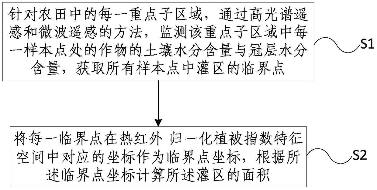
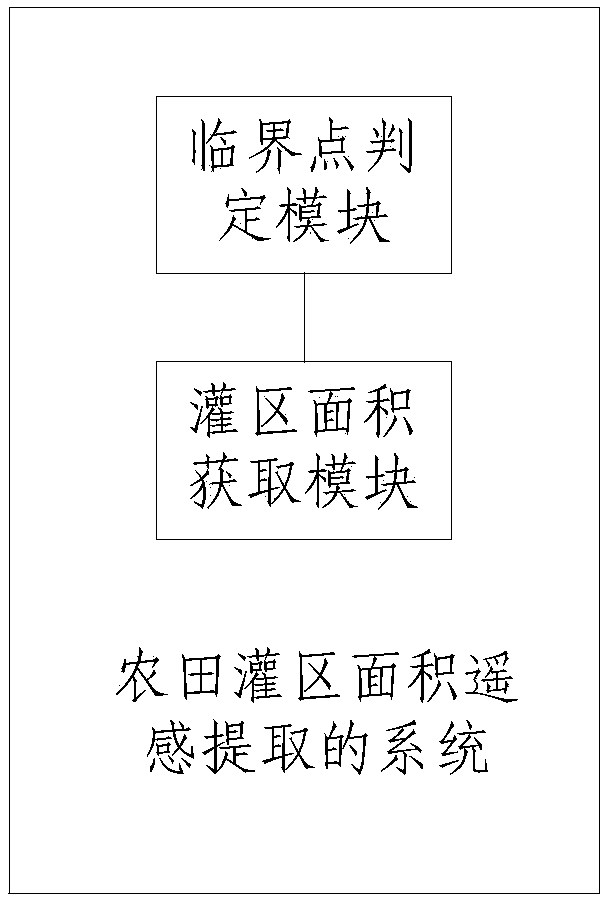
[0046] see figure 1 , is a flow chart of farmland irrigation area remote sensing extraction in an embodiment of the present invention, including: S1, for each key sub-region in the farmland, monitor each sampling in the key sub-region by means of hyperspectral remote sensing and microwave remote sensing The soil moisture content and canopy moisture content of the crops at the point, to obtain the critical point of the irrigation area in all sampling points; S2, the coordinates corresponding to each critical point in the thermal infrared-Normalized Difference Vegetation Index feature space as the critical point coordinates , calculating the area of ​​the irrigated area acc...


PUM


Abstract

The present invention provides a method for farmland irrigation district area remote sensing extraction. The method comprises the steps of: for each key sub area in a farmland, monitoring soil water content and canopy water content of crops at each sampling point in the key sub areas through adoption of a method of a high hyperspectral remote sensing and microwave remote sensing, and obtaining critical points of an irrigation district in all the sampling points; and taking corresponding coordinates of each critical point in a thermal infrared-normalized differential vegetation index feature space as critical point coordinates, and calculating the area of the irrigation district according to the coordinates of the critical points. The method and the system perform remote sensing images to collect data to calculate the normalized differential vegetation index, the soil water content and the canopy water content of the crops to obtain the critical points of the irrigation district in thefarmland and search the coordinate points corresponding to the critical points in the thermal infrared-normalized differential vegetation index feature space so as to divide the range of the irrigation district in the feature space, obtain the area of the irrigation district through calculation of the areas of images elements corresponding to the irrigation district and improve the precision and the efficiency of the irrigation district area extraction method in the farmland.

Description

technical field [0001] The present invention relates to the field of agricultural remote sensing, and more specifically, to a method and system for remote sensing extraction of farmland irrigated areas. Background technique [0002] Irrigation area generally refers to the irrigated area with reliable water source, channel system of introduction, transmission and distribution, and corresponding drainage ditches. It is the product of human economic activities and develops with the development of social economy. The irrigated area is the area of ​​arable land that is irrigated according to irrigation needs. [0003] The remote sensing extraction method of irrigated area has the characteristics of macroscopic, objective, fast and cheap, and has gradually been widely used. At present, this method is mainly divided into time series observation and comparison method of vegetation index in irrigated and non-irrigated areas, Ts-NDVI feature space analysis method, microwave soil mois...

Claims


Application Information

Patent Timeline
Patent Type & Authority Applications(China)
IPC IPC(8): G01B21/28G01N21/25G01N22/04
CPCG01B21/28G01N21/25G01N22/04G01N2021/1793
Inventor 王树东张宝忠吴太夏陈鹤魏征郑姚闽柳树福翟涌光
Owner INST OF REMOTE SENSING & DIGITAL EARTH CHINESE ACADEMY OF SCI
Why Eureka
Try Eureka