Small water conservancy project water surface area and water storage determination method based on remote sensing

A technology of water conservancy engineering and water surface area, which is applied in the fields of structured data retrieval, instrumentation, and electrical digital data processing, etc. The effect of improving the accuracy of water surface distribution, simple and easy versatility, and simple and easy operation

Inactive Publication Date: 2018-02-06
CHINA INST OF WATER RESOURCES & HYDROPOWER RES
View PDF3 Cites 2 Cited by
  • Summary
  • Abstract
  • Description
  • Claims
  • Application Information

AI Technical Summary

Problems solved by technology

[0003] (1) Existing methods are mostly oriented to large-scale reservoirs, and are not suitable for the relationship between water surface area and storage capacity of small-scale water conservancy projects such as small reservoirs and ponds and dams
[0004] (2) Due to the lack of elimination of mountain and cloud shadows in the existing method, the accuracy of the extracted water surface distribution is not high
[0005] (3) Existing methods do not filter out water bodies such as overly large rivers and large reservoirs, finely divided non-pond water bodies and other broken factors when extracting water bodies, which makes the water surface area used for calculating the water surface area and storage capacity relationship of small reservoirs and dams too large
[0006] To sum up, the existing methods for calculating the water surface area and water storage capacity of small reservoirs and dams in the river basin have the problem of inaccurate water surface area and water storage capacity.

Method used


Image

  • Small water conservancy project water surface area and water storage determination method based on remote sensing
  • Small water conservancy project water surface area and water storage determination method based on remote sensing
  • Small water conservancy project water surface area and water storage determination method based on remote sensing

Examples


Embodiment Construction

[0038] In order to make the objectives, technical solutions and advantages of the present invention clearer, the present invention will be further described in detail below with reference to the accompanying drawings. It should be understood that the specific embodiments described herein are only used to explain the present invention, but not to limit the present invention.

[0039] A few notes about this application:

[0040] (1) The target research time is a concept of a moment, which is the actual value of the current moment.

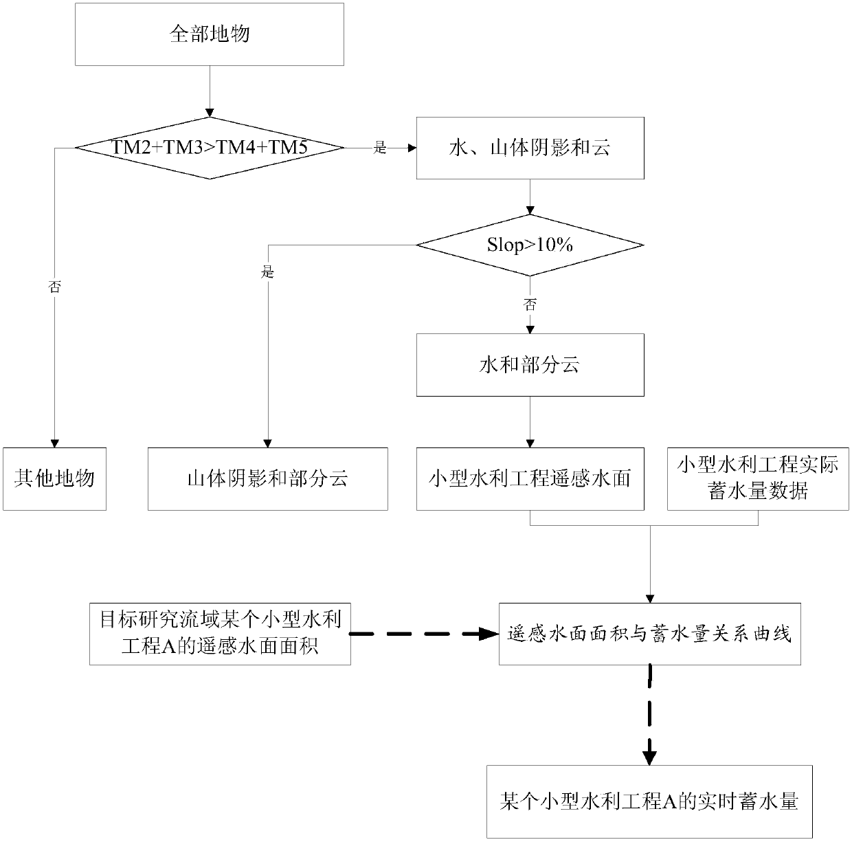
[0041] (2) Eliminate the content of the DEM elevation slope greater than the preset threshold in the preliminary screening spectrum to eliminate the influence of the shadow of the hill.

[0042] (3) The non-water content includes clouds and grid parts generated by photos.

[0043] (4) The preset range is that the remote sensing water surface area is greater than S and the remote sensing water surface area is less than s, and the water bodies whose ...


PUM


Abstract

The invention discloses a small water conservancy project water surface area and water storage determination method based on remote sensing and relates to the remote sensing inversion / reservoir waterresource information / hydrologic monitoring field. The method comprises steps that remote sensing data including a target research basin and the distribution position and actual water storage data of all the small water conservancy projects in the target research basin are acquired; a water surface distribution map of the target research basin is extracted; remote sensing inversion maps of surfacesof the small water conservancy projects are acquired; quality check on remote sensing water surface area data of the small water conservancy projects in the water surface remote sensing inversion maps of water bodies stored by the small water conservancy projects is carried out; a remote sensing water surface area and water storage relationship curve of the target research basin is drafted through taking the remote sensing water surface areas of the small water conservancy projects as abscissas and actual water storage of the small water conservancy projects as ordinates in a coordinate system. The method is advantaged in that water surface extraction precision of the small water conservancy projects is improved, good universality is realized, and operation is simple and easy.

Description

technical field [0001] The invention relates to the field of remote sensing inversion / reservoir water resource information / hydrology monitoring, in particular to a method for estimating the water surface area and water storage capacity of small projects based on remote sensing. Background technique [0002] It is quite difficult to collect the real-time operation of small water conservancy projects such as small and medium-sized reservoirs and ponds and dams in the basin using the existing technology, and the collected information is not complete. At present, there are methods to obtain the data of small water conservancy projects by using the relationship between water surface area and storage capacity, such as: the relationship between water surface area and storage capacity of small reservoirs and dams in the basin based on remote sensing, threshold method, difference method, ratio method, density segmentation method, chromaticity Discrimination method, ratio measurement ...

Claims


Application Information

Patent Timeline
IPC IPC(8): G06K9/00G06F17/30G06Q50/06
CPCG06F16/29G06Q50/06G06V20/182
Inventor 雷晓辉廖卫红黄晓敏王明元桂梓玲田雨权锦甘治国王超
Owner CHINA INST OF WATER RESOURCES & HYDROPOWER RES
Why Eureka
Try Eureka