Method of real-time coordinate transformation of ground-based augmentation system

A ground-based augmentation system and coordinate conversion technology, applied in geographic information databases, special data processing applications, instruments, etc., can solve the problems of reduced success rate of baseline calculation, limited application range, and ineffectiveness, etc., to ensure reliability and stability performance, improve service quality, and have a wide range of applications

Inactive Publication Date: 2017-09-22
QIANXUN SPATIAL INTELLIGENCE INC
View PDF3 Cites 5 Cited by
  • Summary
  • Abstract
  • Description
  • Claims
  • Application Information

AI Technical Summary

Problems solved by technology

In the western part of China, the movement of the crustal plate is more complicated, and the velocity direction is inconsistent. If the ground augmentation system uses WGS84 or CGCS2000 coordinates, the baseline will be distorted, resulting in a decrease in the success rate of the baseline solution and a poor service effect of NRTK.
[0003] As time goes on, the baseline distortion caused by the plate movement will become more and more serious, and the success rate and service quality of the existing ground-based augmentation system baseline calculation will continue to decline
The existing technology usually adopts the method of seven-parameter conversion, but the application range of the seven-parameter conversion method is usually limited (hundreds of square kilometers), especially in areas where plate movement is more complicated, and the seven-parameter conversion method may not be effective

Method used


Image

  • Method of real-time coordinate transformation of ground-based augmentation system
  • Method of real-time coordinate transformation of ground-based augmentation system

Examples


Embodiment Construction

[0017] The present invention will be further described below in conjunction with the accompanying drawings and specific embodiments. The embodiments of the present invention are only used to illustrate the technical solutions of the present invention rather than limit the protection scope of the present invention.

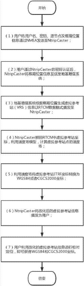
[0018] Such as figure 1 , figure 2 As shown, the present invention proposes a method for real-time coordinate transformation of a ground-based augmentation system, comprising the following steps:

[0019] (1) The user sends the user name, password, source node and approximate location information to NtripCaster via NMEA;

[0020] (2) After the user passes the password authentication of NtripCaster, NtripCaster will send the approximate location information to the ground-based augmentation system;

[0021] (3) The ground-based augmentation system generates virtual reference station information based on the ITRF framework based on the approximate position and broa...


PUM


Abstract

The invention relates to a method of real-time coordinate transformation of a ground-based augmentation system. The method comprises the following steps: sending a user name, a password, a source node and coarse position information to a NtripCaster by a user; sending the coarse position information to the ground-based augmentation system by the NtripCaster; broadcasting virtual reference station information of a coarse position to the NtripCaster by the ground-based augmentation system; decoding virtual reference station coordinates in an RTCM by the NtripCaster, and calculating velocity fields of virtual reference sites; transforming the virtual reference station ITRF coordinates into WGS84 or CGCS2000 coordinates by the NtripCaster; broadcasting the converted virtual reference station information for the user by the NtripCaster; and utilizing the converted virtual reference station information to perform relative positioning by the user, and obtaining the WGS84 and CGCS2000 coordinates. According to the method, coordinate transformation of the ground-based augmentation system is realized, the reliability and the stability of services of the ground-based augmentation system are guaranteed, an application range is wide, and the generality is high.

Description

technical field [0001] The invention relates to a ground-based augmentation system, in particular to a method for real-time coordinate conversion of the ground-based augmentation system. Background technique [0002] On July 1, 2008, my country officially launched the new geocentric three-dimensional geodetic coordinate system CGCS2000. The framework of CGCS2000 is consistent with ITRF97, epoch 2000.0. The ground-based augmentation system adopts the ITRF frame (latest epoch) coordinates, and broadcasts WGS84 or CGCS2000 coordinates to the outside world. For now, ITRF is the most widely used and most accurate geocentric coordinate framework internationally recognized. Due to the influence of plate movement, the points on the surface of the earth are moving and changing, but the speed of movement is different in different places. As far as China is concerned, the annual change is about 3-4cm / year, and the direction of movement between the east and the west is not consistent. ...

Claims


Application Information

Patent Timeline
Patent Type & Authority Applications(China)
IPC IPC(8): G06F17/30
CPCG06F16/29
Inventor 冯彦同
Owner QIANXUN SPATIAL INTELLIGENCE INC
Why Eureka
Try Eureka