GPS data based automatic construction method and system for open-pit mine road network

A GPS data, automatic construction technology, applied in the direction of image data processing, 2D image generation, instruments, etc., can solve the problems of poor accuracy, inapplicability, frequent changes of mine road network, etc., to ensure safe, automatic and accurate construction Effect

Active Publication Date: 2015-11-18
CENT SOUTH UNIV +1
View PDF5 Cites 7 Cited by
  • Summary
  • Abstract
  • Description
  • Claims
  • Application Information

AI Technical Summary

Problems solved by technology

With the application and development of informatization and intelligence in mines, the demand for automatic construction and rapid update of road networks in open-pit mines is increasingly urgent. Existing road network construction technologies for open-pit mines have problems such as low degree of automation, long cycle, high cost and precision. Inadequate problems, resulting in the dilemma that the construction of the open-air road network cannot keep up with the actual development and changes
[0003] The existing road network construction methods are mainly divided into two categories: one is the traditional surveying and mapping method, which has defects such as low degree of automation, long cycle, and high cost. At the same time, due to the continuous advancement of mining, the mine road network changes frequently and irregularly. However, this type of method cannot be effectively used in the actual production and application of open-pit mines; the other is the road network construction method based on GPS data collection. Many researchers have studied the automatic construction method of urban road networks on the basis of GPS data. And achieved certain results, but no one has studied the automatic construction of road networks for open-pit mines
[0004] Shi Wenhuan proposed an automatic generation method of road network raster digital map based on GPS positioning. A road condition information generation method based on bus GPS trajectory data and a method for generating road network vector maps using urban floating vehicle GPS data proposed by Sun Dihua. These methods are only suitable for the automatic construction of urban road networks. In the method, the bus The site is used as a reference, or the urban road route is relatively fixed as a premise, which cannot be applied to the complex situation of the open-pit mine road network; Shi Wenzhong proposed a 3D road generation method based on airborne LIDAR and GIS collaboration, which mainly studies road point clouds Cutting, automatic layering of viaduct roads and elevation interpolation, etc., the above-mentioned problems do not exist in open-pit mine roads, so this method cannot be applied
[0005] In view of the above phenomena, a fast and accurate automatic network construction method is urgently needed to solve the problem of automatic construction of open-pit mine road network based on GPS data

Method used


Image

  • GPS data based automatic construction method and system for open-pit mine road network
  • GPS data based automatic construction method and system for open-pit mine road network
  • GPS data based automatic construction method and system for open-pit mine road network

Examples


Embodiment Construction

[0060] In order to make the purpose, technical solutions and advantages of the embodiments of the present invention clearer, the technical solutions in the embodiments of the present invention will be clearly and completely described below in conjunction with the drawings in the embodiments of the present invention. Obviously, the described embodiments It is a part of embodiments of the present invention, but not all embodiments. Based on the embodiments of the present invention, all other embodiments obtained by persons of ordinary skill in the art without creative efforts fall within the protection scope of the present invention.

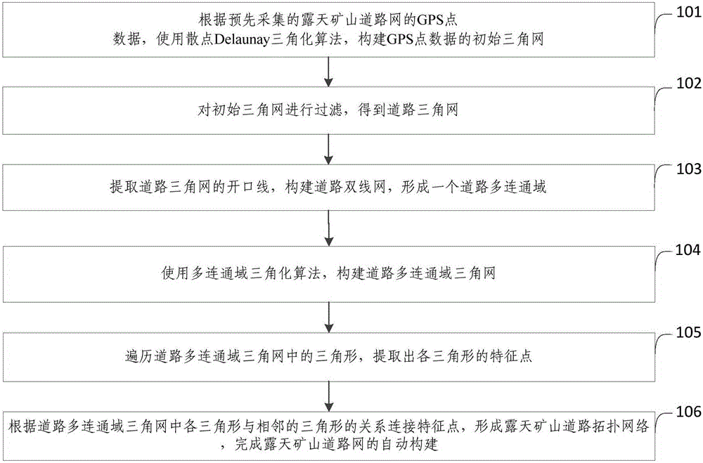
[0061] figure 1 It shows the flow chart of the method for automatically constructing the open-pit mine road network based on GPS data provided by Embodiment 1 of the present invention, see figure 1 , the method for automatically constructing the open-pit mine road network based on GPS data provided by the embodiment of the present invention inclu...


PUM


Abstract

The invention provides a GPS data based automatic construction method and system for open-pit mine road network . The method comprises: S1, constructing an initial triangulation network of GPS point data by using a scattered point Delaunay triangulation algorithm according to pre-collected GPS point data of the open-pit mine road network; S2, filtering the initial triangulation network to obtain a road triangulation network; S3, extracting an opening line of the road triangulation network to construct a road double-line network and form a road multi-communication region; S4, constructing a road multi-communication region triangulation network by using a multi-communication region triangulation algorithm; S5, traversing triangular shapes in the road multi-communication region triangulation network to extract feature points of each triangular shape; and S6, connecting the feature points according to the relation between each triangular shape and the adjacent triangular shape in the road multi-communication region triangulation network, so as to form an open-pit mine road topology network. With the adoption of the automatic construction method, the open-pit mine road network can be automatically constructed.

Description

technical field [0001] The invention relates to the field of road construction in open-pit mines, in particular to a method and system for automatically constructing road networks in open-pit mines based on GPS data. Background technique [0002] The open-pit mine road network is a road network that truly reflects the geographical location information of the open-pit mine roads and the topological relationship between the roads. It is the basis for the open-pit mine truck dispatching system and mining equipment operation monitoring and management. With the application and development of informatization and intelligence in mines, the demand for automatic construction and rapid update of road networks in open-pit mines is increasingly urgent. Existing road network construction technologies for open-pit mines have problems such as low degree of automation, long cycle, high cost and precision. Inadequate problems, resulting in the dilemma that the construction of the open-air ro...

Claims


Application Information

Patent Timeline
Patent Type & Authority Applications(China)
IPC IPC(8): G06T11/00
Inventor 王李管陈鑫李金玲刘定一任助理
Owner CENT SOUTH UNIV
Why Eureka
Try Eureka