Multi-user communication method based on geographic position and spatial range
A geographical location and spatial range technology, applied in the field of data communication, can solve the problems of non-friends or unfamiliar people who do not have software to use and cannot establish communication links, etc., to achieve a good user experience effect
- Summary
- Abstract
- Description
- Claims
- Application Information
AI Technical Summary
Problems solved by technology
Method used
Image


Examples
Embodiment 1
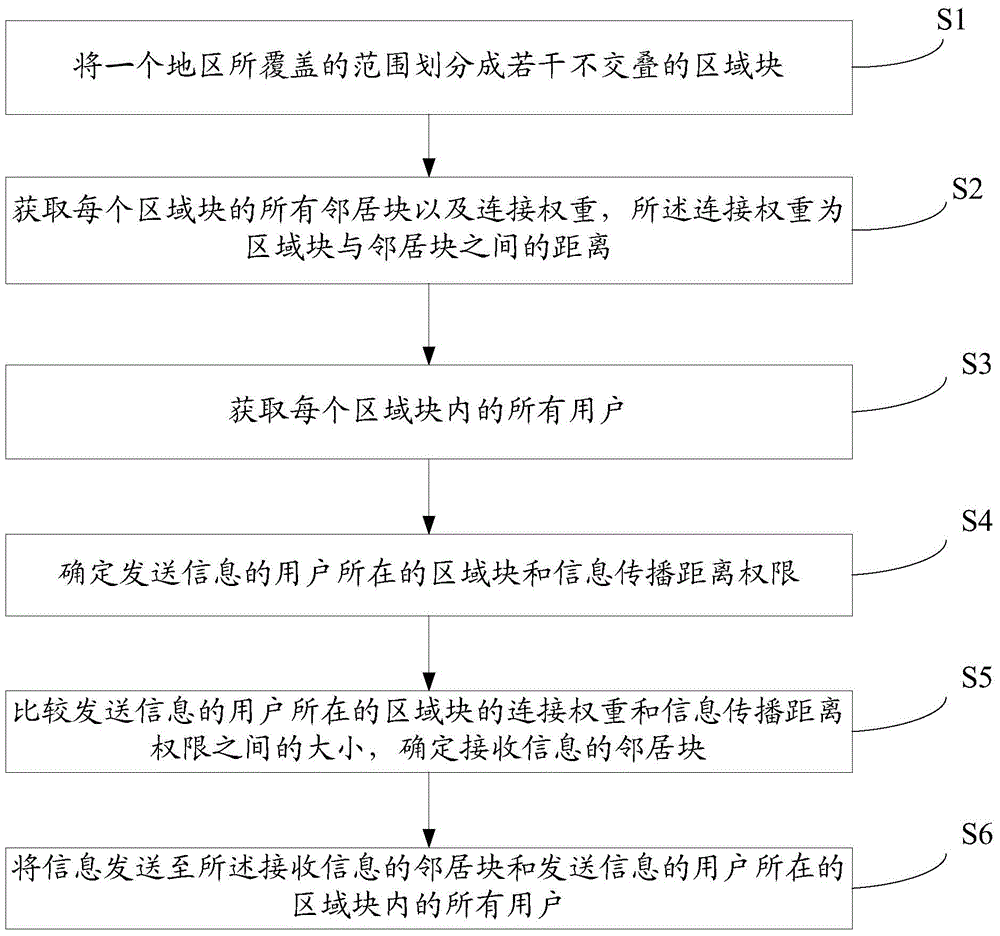
[0064] Such as figure 1 As shown, the embodiment of the present invention provides a multi-user communication method based on geographic location and spatial range, including the following steps:
[0065] S1: Divide the area covered by a region into several non-overlapping area blocks;
[0066] S2: Obtain all neighbor blocks and connection weights of each area block, where the connection weight is the distance between the area block and the neighbor block;
[0067] S3, get all users in each area block;
[0068] S4, determining the area block where the user sending the information is located and the information propagation distance authority;
[0069] S5, comparing the connection weight of the area block where the user sending the information is located and the size of the information propagation distance authority, and determining the neighbor block receiving the information;
[0070] S6: Send the information to all users in the area block where the neighbor block receiving the informati...
Embodiment 2
[0074] Such as figure 2 with image 3 As shown, in this embodiment, S1 may include the following steps:
[0075] S101: Set the starting point P of the divided area block, and set the two-dimensional coordinates of the starting point P as: x=0, y=0;
[0076] S102: Using the starting point P as the starting point of the upper left corner of the area, divide a region block with a length of Height and a width of Width;
[0077] S103. Compare the x coordinate of the starting point P with the area width range value. If the x coordinate of the starting point P is greater than the area width range value, execute S104, otherwise go to S102; where the x coordinate is: x=x+Width;
[0078] S104. Set the x coordinate of the starting point P to 0, compare the y coordinate of the starting point P with the area height range value, if the y coordinate of the starting point P is greater than the area height range value, end, otherwise go to S102; where y The coordinates are: y=y+Height.
[0079] Among ...
Embodiment 3
[0088] Such as Figure 4 As shown, in this embodiment, S2 may include the following steps:
[0089] S201: Establish a neighbor list NeighborList of the area block, and initialize the neighbor list, the neighbor list contains 0 entries;
[0090] S202. Establish a border list BorderList of the area block, and initialize the border list. Each entry of the edge list stores an edge of the area block, and put all the edges of the area block into the edge list; set the added count counter AddedCount, and set Is 0;
[0091] S203: Obtain all the area blocks that intersect with the edges in the edge list BorderList and are not in the neighbor list NeighborList, and put them into the list TestList;
[0092] S204: Take out an area block from the list TestList and put it into a variable TempArea;
[0093] S205: Calculate the distance from the center point of the variable TempArea to the center point of the area block, if the distance is less than the set maximum neighbor threshold MaxDistance, exec...
PUM
 Abstract
Description
Claims
Application Information
 - R&D
- Intellectual Property
- Life Sciences
- Materials
- Tech Scout
- Unparalleled Data Quality
- Higher Quality Content
- 60% Fewer Hallucinations
Browse by: Latest US Patents, China's latest patents, Technical Efficacy Thesaurus, Application Domain, Technology Topic, Popular Technical Reports.
© 2025 PatSnap. All rights reserved.Legal|Privacy policy|Modern Slavery Act Transparency Statement|Sitemap|About US| Contact US: help@patsnap.com