
Method for identifying peak periods of road networks on basis of floating cars

A technology of peak hours and identification methods, applied in special data processing applications, traffic flow detection, instruments, etc., can solve the problems of different peak hours and affect the accuracy of AADT intelligent estimation, etc.

Active Publication Date: 2014-04-30
ANHUI KELI INFORMATION IND
View PDF3 Cites 26 Cited by
  • Summary
  • Abstract
  • Description
  • Claims
  • Application Information

AI Technical Summary

Problems solved by technology

However, the peak hours of each city are different. If a unified standard is used, it is obviously different from the actual peak hours of each city, which will affect the accuracy of AADT's intelligent estimation.

Method used


Image

  • Method for identifying peak periods of road networks on basis of floating cars
  • Method for identifying peak periods of road networks on basis of floating cars
  • Method for identifying peak periods of road networks on basis of floating cars

Examples


Embodiment Construction

[0068] In order to have a further understanding and understanding of the structural features and the achieved effects of the present invention, the preferred embodiments and accompanying drawings are used for a detailed description, as follows:

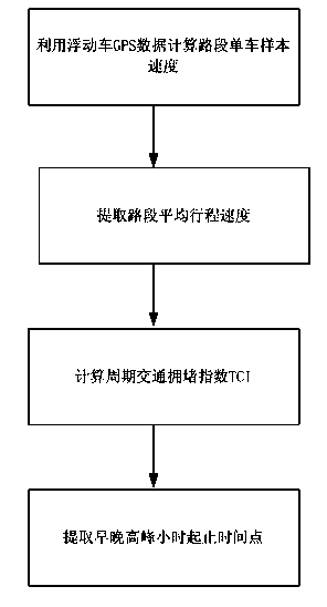
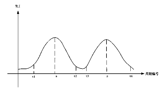
[0069] Such as figure 1 As shown, a kind of road network peak hour identification method based on floating car according to the present invention comprises the following steps:

[0070] The first step is to use the GPS data of the floating car to calculate the sample speed of the bicycle on the road section.

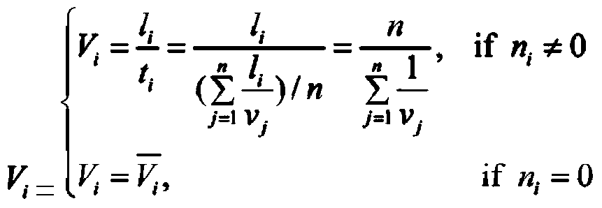
[0071] Use the GPS data of the floating car to calculate the average travel speed of the single vehicle sample in a statistical period of the road section. First, obtain the path information {P i , i=1, 2, L, n}. Second, based on GPS data it is possible to pass the path length Δd j and time difference Δt j Get the average travel speed of this path Again, when there is only one road section, it means not to cross the inters...


PUM


Abstract

The invention relates to a method for identifying peak periods of road networks on the basis of floating cars. The method includes steps of computing speeds of single vehicle samples of road sections by the aid of GPS (global positioning system) data of the floating cars; extracting average travel speeds of the road sections; computing periodic traffic congestion indexes TCI; extracting morning and evening peak hour starting and ending time points. Compared with the prior art, the method has the advantages that the shortcoming of deficiency of a method for identifying peak periods of road networks on the basis of a floating car technology at present can be overcome; time-varying traffic laws of the road networks can be analyzed via the existing floating car technology and an urban road congestion analysis system, so that the peak periods of the road networks can be extracted.

Description

technical field [0001] The invention relates to the technical field of road traffic planning, in particular to a method for identifying road network peak hours based on floating vehicles. Background technique [0002] Floating car technology is a technology to obtain road traffic conditions based on the dynamic position information of vehicles running on the road surface. The floating car (taxi or bus) with GPS information can collect the displacement information of the vehicle in real time, and the time series of vehicle position The coordinates are matched with the map, and the speed data of the floating vehicle can be obtained. The floating car technology can store the data collected for one year in the database, and use the speed information of the periodic road section to obtain the flow information of the periodic road section. [0003] AADT (annual average daily traffic) is a very important parameter for traffic models and management decisions, and plays a key role i...

Claims


Application Information

Patent Timeline
IPC IPC(8): G06F19/00G08G1/01
Inventor 邹娇陶刚刘俊高万宝方林李立超
Owner ANHUI KELI INFORMATION IND
Learn More