Large scale topographical map surveying and mapping method utilizing rotating TIN (triangulated irregular network) and distance and included angle dual-weight interpolation method

A technique of scale and interpolation, applied in the field of geographic information systems

Inactive Publication Date: 2012-10-31
黄桂芝
View PDF5 Cites 4 Cited by
  • Summary
  • Abstract
  • Description
  • Claims
  • Application Information

AI Technical Summary

Problems solved by technology

[0006] The purpose of the present invention is to provide a large-scale topographic map surveying and mapping method using a rotating TIN network and a double-weighted interpolation method for distance and angle, so as to solve the lack of echo and coordination between the data structures of the surface entities, and there is no composition between adjacent data. The influence of the included angle between adjacent triangular planes is directly considered as a defect

Method used


Image

  • Large scale topographical map surveying and mapping method utilizing rotating TIN (triangulated irregular network) and distance and included angle dual-weight interpolation method
  • Large scale topographical map surveying and mapping method utilizing rotating TIN (triangulated irregular network) and distance and included angle dual-weight interpolation method
  • Large scale topographical map surveying and mapping method utilizing rotating TIN (triangulated irregular network) and distance and included angle dual-weight interpolation method

Examples


specific Embodiment approach 1

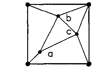
[0115] Specific implementation mode 1: the following combination Figure 8 to Figure 13 This embodiment will be described in detail. This embodiment includes the following steps:

[0116] 1. The mapping scale is 1:500, the distance between topographic fragments is 15m, and the distance between topographic fragments is 30m as the side length of the basic square.

[0117] 2. Arrange a surveying and mapping point at each of the four vertices of the basic square, and arrange three surveying and mapping points scattered in the basic square, see the schematic figure 1 , The plane coordinates of the four vertices are (0, 0), (30, 0), (30, 30) and (0, 30), point a is (9, 9), point b is (12, 22.5) , Point c is (24,12), the above three points a, b, and c are connected to form a triangle, the above three internal surveying points are connected to form a triangle, and then a vertex is selected from the four vertices of the basic square, and the distance between the vertex and the The sum of t...

specific Embodiment approach 2

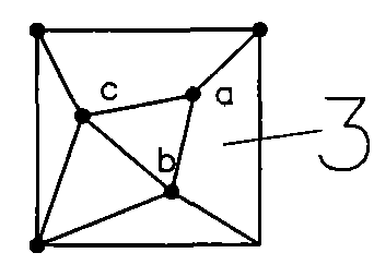
[0194] Specific embodiment two; see schematic figure 1 To indicate Image 6 , The difference between this embodiment and the first embodiment is: in step 2, the three surveying points scattered in the basic square are a(6,6), b(15,24), c(24, 15); Other steps are the same as the first embodiment.

[0195] Compared with the first embodiment, the first embodiment has better dispersion along the trend and trend of the surveying points in the basic unit; this embodiment has better dispersion along the trend and trend of the surveying points in the supporting unit; 2. The length between two adjacent surveying and mapping points in the surveying and mapping network is reduced compared to the first embodiment, and it is reduced within the range of 0.43 to 0.67 times the side length of the basic square.

specific Embodiment approach 3

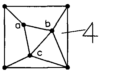
[0196] Specific implementation mode three: see Figure 14 to Figure 19 The difference between this embodiment and the first embodiment is: in step two, one surveying point is arranged at each of the four vertices of the basic square, and three surveying points are scattered in the basic square, and the above three internal points are connected to form a triangle , And then arrange a surveying and mapping point at the right midpoint of the basic square, adding up to the surveying and mapping points on the four vertices of the basic square and the three surveying and mapping points scattered in the basic square for a total of eight surveying and mapping points. Signal Figure 14 The eight surveying and mapping points are (0, 0), (30, 0), (30, 30), (0, 30), a(8.31, 13.62), b(15, 24), c(20.37, 6 ), d(30, 15). Connect the surveying point at the midpoint on the right of the square to the two surveying points of the nearest triangle inside, respectively, and place the two vertices of ...


PUM


Abstract

The invention provides a large scale topographical map surveying and mapping method utilizing a rotating TIN (triangulated irregular network) and a distance and included angle dual-weight interpolation method, and relates to a topographical map surveying and mapping method. The shortcomings that echoes and matching between entity data structures of the earth's surface are insufficient, and influence of an include angle between each two adjacent triangular planes formed by adjacent data is not directly considered in the prior art are overcome. The large scale topographical map surveying and mapping method comprises the following steps of arranging surveying and mapping points at joints of the rotating assorted network; adjusting a certain surveying and mapping point to a new position if the surveying and mapping point in the rotating TIN can be used as a topographical feature point after the surveying and mapping point is adjusted within a range, which is centered at the surveying and mapping point, of 0.15 times of the side length of a basic square; adding other topographical feature points according to a total topographical feature; connecting each added topographical feature point with three vertexes of a triangle with the topographical feature point to form a local secondary encryption network; performing elevation interpolation by utilizing the distance and included angle dual-weight interpolation method; making contour lines; and making a topographical map and a topographical three-dimensional perspective drawing.

Description

Technical field [0001] The invention relates to a large-scale topographic map surveying and mapping method in the field of geographic information systems. Background technique [0002] All DEMs are fully rotated and locally interpolated. The interpolation method is an important guarantee for improving the accuracy and high fidelity performance of DEM, but the most important prerequisite that affects the accuracy and high fidelity performance of the DEM local interpolation results is a good mapping point Distribution, that is, data structure. If the layout of surveying and mapping points is unreasonable, the overall data structure cannot reflect or extract important factors or trends of surface changes, or the reflected or extracted factors or trends are relatively rough, then interpolation must not achieve good results. That is, the interpolation should be performed on a good data structure, the data structure (DEM data model) is the first important, and the interpolation method...

Claims


Application Information

Patent Timeline
Patent Type & Authority Applications(China)
IPC IPC(8): G09B29/00
Inventor 黄桂芝冯彬商宇航田立慧王立媛
Owner 黄桂芝
Why Eureka
Try Eureka