
Outdoor positioning method and positioning receiver

A receiver and external positioning technology, applied to satellite radio beacon positioning systems, measuring devices, instruments, etc., can solve problems such as inability to achieve positioning and limited capabilities

Active Publication Date: 2012-09-19
BEIJING UNIV OF POSTS & TELECOMM
View PDF5 Cites 5 Cited by
  • Summary
  • Abstract
  • Description
  • Claims
  • Application Information

AI Technical Summary

Problems solved by technology

[0005] In the process of realizing the present invention, the inventors have found that the prior art has at least the following problems: positioning cannot be achieved when only NLOS exists in the prior art, and the ability to detect non-line-of-sight signals to eliminate non-line-of-sight errors is limited. There are many uncertain factors that make it impossible to achieve positioning

Method used


Image

  • Outdoor positioning method and positioning receiver
  • Outdoor positioning method and positioning receiver
  • Outdoor positioning method and positioning receiver

Examples


Embodiment 1

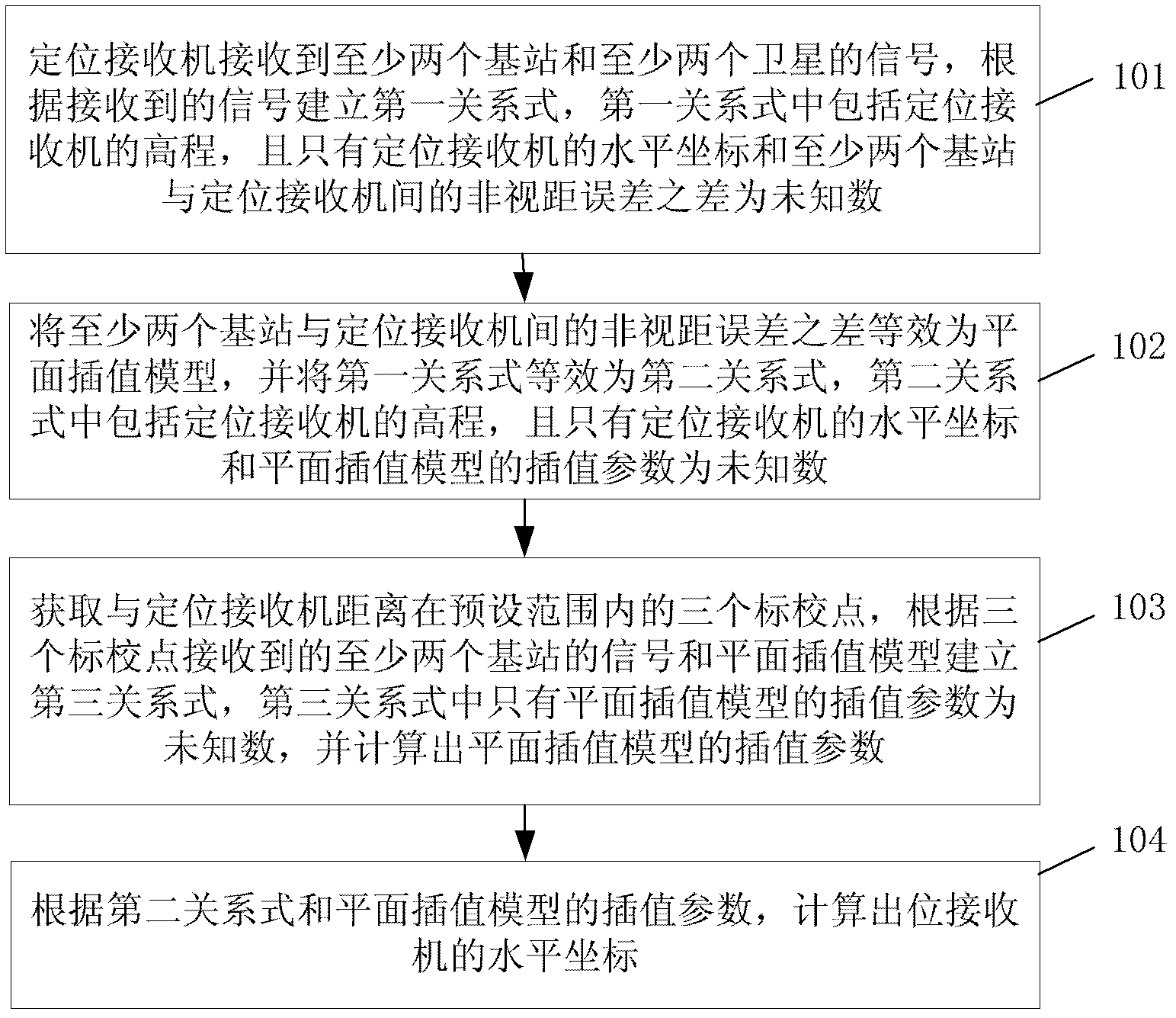
[0051] see figure 1 , an embodiment of the present invention provides an outdoor positioning method, the method comprising:

[0052] Step 101: The positioning receiver receives signals from at least two base stations and at least two satellites, and establishes a first relational expression according to the received signals. The first relational expression includes the elevation of the positioning receiver, and only the level of the positioning receiver the difference between the coordinates and the non-line-of-sight error between at least two base stations and the positioning receiver is unknown;

[0053] Step 102: The non-line-of-sight error difference between at least two base stations and the positioning receiver is equivalent to a planar interpolation model, and the first relational expression is equivalent to a second relational expression, which includes the positioning receiver , and only the horizontal coordinates of the positioning receiver and the interpolation par...

Embodiment 2

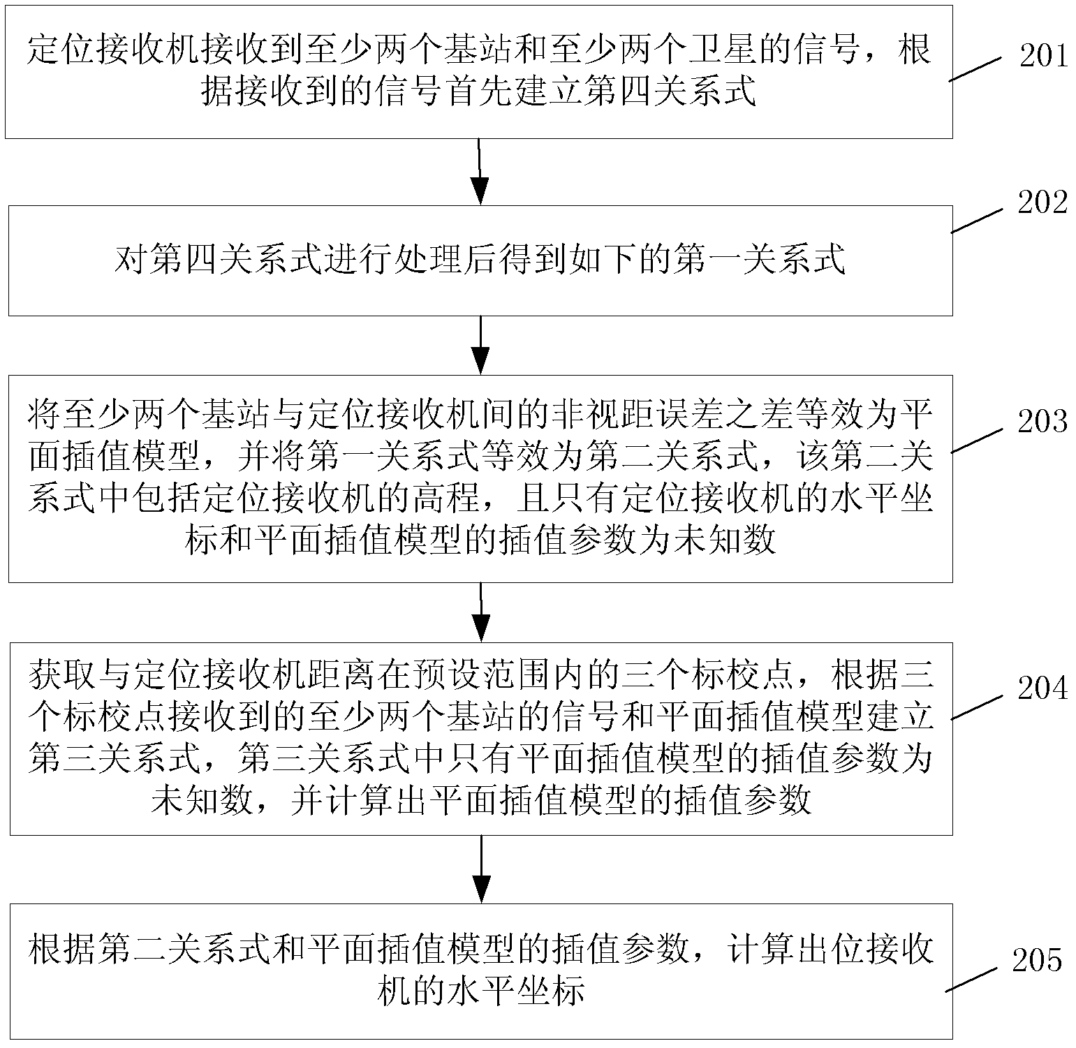
[0058] see figure 2 , an embodiment of the present invention provides an outdoor positioning method, the method comprising:

[0059] Step 201: The positioning receiver receives signals from at least two base stations and at least two satellites, and first establishes a fourth relational expression according to the received signals;

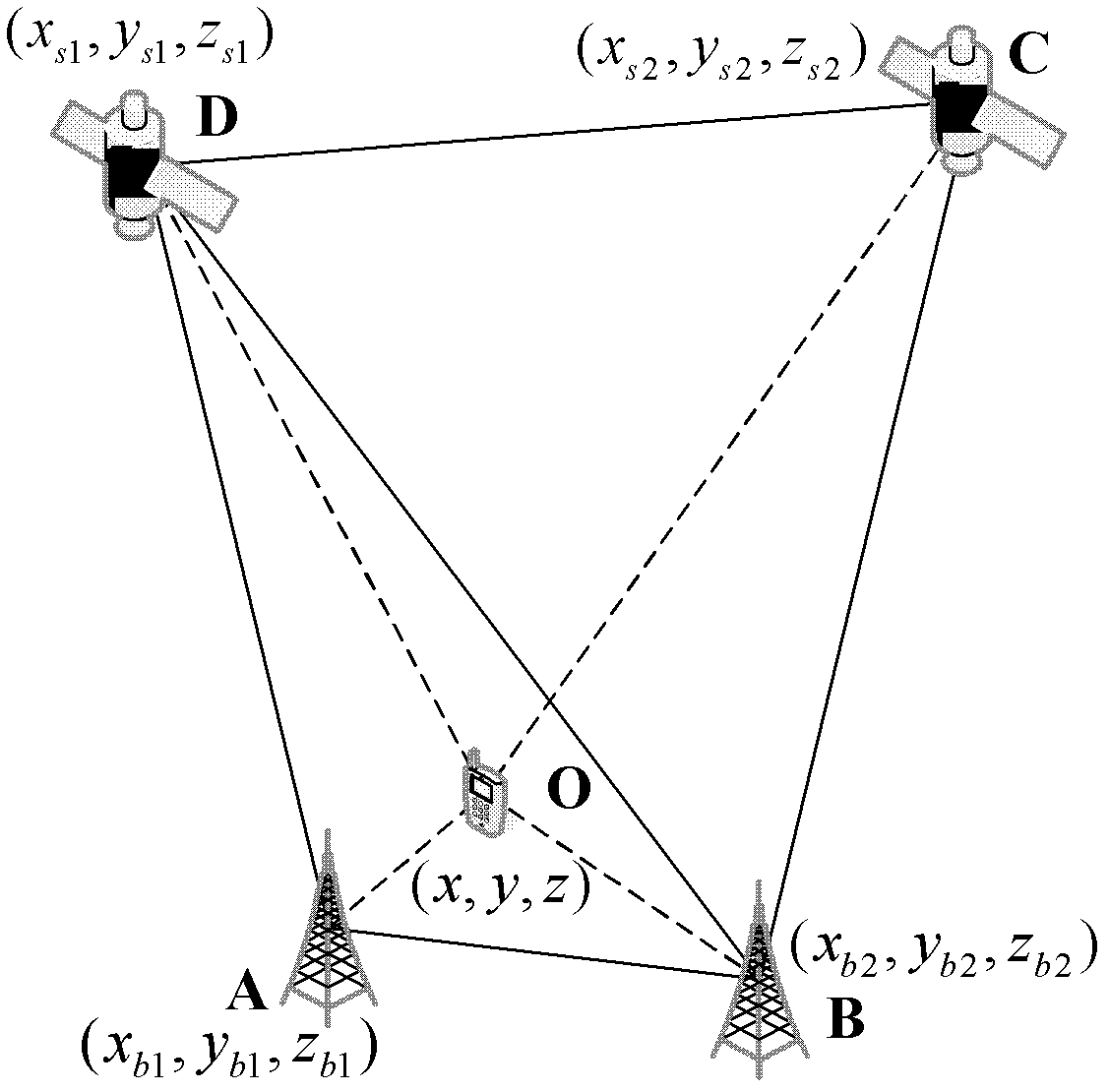
[0060] Wherein, the first, second, third, fourth, etc. in the embodiment of the present invention are only codes used to distinguish each relational expression, and do not limit the relational expression itself. In the embodiment of the present invention, the positioning receiver receives the satellite signal with the number of satellites greater than or equal to 2 and the base station signal with the number of base stations greater than or equal to 2, and establishes the following relational expression according to the received signal:

[0061] ρ b ...

Embodiment 3

[0098] see Figure 4 , the embodiment of the present invention provides a positioning receiver, the positioning receiver includes a relationship module 301, an equivalent module 302, a first calculation module 303 and a second calculation module 304;

[0099] The relational module 301 is configured to receive signals from at least two base stations and at least two satellites, and establish a first relational expression according to the received signals, the first relational expression includes the elevation of the positioning receiver, and only the horizontal coordinates of the positioning receiver and the difference between the non-line-of-sight error between at least two base stations and the positioning receiver is unknown;

[0100] The equivalence module 302 is used to equivalent the non-line-of-sight error difference between at least two base stations and the positioning receiver as a planar interpolation model, and equivalent the first relational expression in the relat...


PUM


Abstract

The invention discloses an outdoor positioning method and a positioning receiver, belonging to the field of positioning. The method comprises the following steps of: receiving signals of at least two base stations and at least two satellites by the positioning receiver, establishing a first relational expression, validating the difference of non-line-of-sight errors among the at least two base stations and the positioning receiver into a plane interpolation model, and calculating interpolation parameters of the plane interpolation model; and according to a second relational expression and theinterpolation parameters of the plane interpolation model, calculating the horizontal coordinates of the positioning receiver. According to the invention, the joint positioning is performed through combining a satellite navigation system and a ground mobile network, and a barometric altimeter is added for assisting, thereby achieving the completed coverage of positioning signals and the better geometric distribution of positioning sources; and on the premise of maintaining that the measurement error of the original pseudo-range of the satellite navigation system is not changed, the pseudo-range is estimated indirectly by using the plane interpolation model, thereby effectively restraining the non-line-of-sight errors arising from the ground network, greatly improving the positioning accuracy, and providing users with more accurate positioning information.

Description

technical field [0001] The invention relates to the field of positioning, in particular to an outdoor positioning method and a positioning receiver. Background technique [0002] With the continuous improvement of people's material living standards, more and more people have a strong dependence on the location information of themselves and surrounding things. At present, satellite positioning systems can achieve positioning accuracy outdoors and provide users with high-quality location services. However, between large buildings, urban canyons and dense forest spaces, due to severe attenuation of satellite signals or even failure to reach them, it is difficult to use satellite navigation systems alone. The positioning accuracy is low or the positioning cannot be completed. [0003] At present, the terrestrial broadcasting / communication network has a wide coverage and can provide users with enough base station information to complete positioning in the above-mentioned harsh o...

Claims


Application Information

Patent Timeline
Patent Type & Authority Applications(China)
IPC IPC(8): G01S19/46G01S19/25
Inventor 邓中亮杨磊尹露席岳刘竞超李晓敏
Owner BEIJING UNIV OF POSTS & TELECOMM
Learn More