
Detection method of daytime land radiation fog based on object and timing sequence image orientation

An object-oriented, detection method technology, applied in the field of daytime terrestrial radiation fog remote sensing detection, can solve the problem of indistinguishable low cloud and fog, and achieve the effect of avoiding indistinguishable problems.

Inactive Publication Date: 2013-12-04
WUHAN UNIV
View PDF2 Cites 0 Cited by
  • Summary
  • Abstract
  • Description
  • Claims
  • Application Information

AI Technical Summary

Problems solved by technology

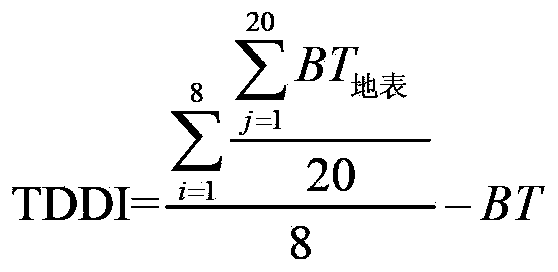
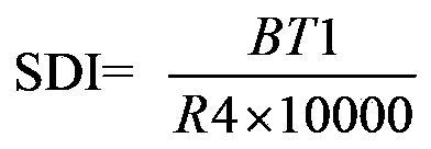
[0016] Aiming at the problem of separation of low clouds and fog in daytime terrestrial radiation fog detection and the limitation of polar orbiting satellites in fog detection, this invention selects MTSAT-2R geostationary satellite data and proposes a daytime terrestrial radiation fog based on object-oriented and time-series images The detection algorithm realizes the separation of cloud and fog based on object area features and time series features, avoiding the indistinguishability of low clouds and fog due to the similarity of spectrum and texture

Method used


Image

  • Detection method of daytime land radiation fog based on object and timing sequence image orientation
  • Detection method of daytime land radiation fog based on object and timing sequence image orientation
  • Detection method of daytime land radiation fog based on object and timing sequence image orientation

Examples


Embodiment Construction

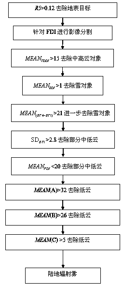
[0045] According to the MTSAT-2R static satellite data obtained by the MTSAT-2R satellite, the invention detects the daytime land radiation fog. The flow of the technical solution provided can be automatically run using computer software technology. The technical solution of the present invention will be described in detail in conjunction with the accompanying drawings and the embodiments of the present invention. Such as figure 1 , the implementation process of the embodiment includes the following steps:

[0046] Step 1. For the MTSAT-2R data at the current detection time point, determine the reflectance of the fifth band of each pixel If it is greater than the preset reflectance threshold, then it is judged that the pixel belongs to the surface target and removed, otherwise it is kept, and the pixel-based cloud, fog, and snow targets are obtained.

[0047] The embodiment utilizes the high reflectivity characteristic of cloud, fog and snow in the 5th band (visible light...


PUM


Abstract

The invention discloses a detection method of daytime land radiation fog based on object and timing sequence image orientation, wherein the method comprises the following steps of: constructing a fog detection characteristic parameter based on a single image by utilizing spectrum and texture characteristics of fog presented on static satellite data, and separating high clouds, middle clouds and partial low clouds as well as snow and fog; and at the same time, introducing timing sequence remote sensing images according to growing and elimination characteristics of the land radiation fog, and separating the low clouds and fog which can not be separated from the single image in the timing sequence images. Through the detection method of land radiation fog disclosed by the invention, the separation of clouds and fog based on object region characteristics and timing sequence characteristics is realized, the problem that the low clouds and fog can not be distinguished due to the similarity of spectrum and texture characteristics is avoided, and a favorable fog detection effect is obtained.

Description

technical field [0001] The method belongs to the technical field of disaster remote sensing, and in particular relates to a new daytime land radiation fog remote sensing detection method based on object-oriented and time-series images. Background technique [0002] The fog detection method based on satellite remote sensing technology is to use the large-scale, high temporal and spatial resolution, and high spectral resolution data of various satellites (stationary satellites and polar orbiting satellites) for fast and dynamic fog detection. Compared with the previous point-like fog observation, the fog detection method based on satellite remote sensing technology has incomparable potential advantages, mainly in the aspects of large detection range, fast data update, objective detection results, and low cost. Therefore, satellite remote sensing technology is applicable In heavy fog detection. [0003] In 1974, Gurka used the visible light band of the SMS-1 meteorological sat...

Claims


Application Information

Patent Timeline
Patent Type & Authority Patents(China)
IPC IPC(8): G01W1/00
Inventor 李维杜娟
Owner WUHAN UNIV
Learn More