Method for performing remote-sensing monitoring on soil moisture content
A technology of soil moisture content and remote sensing monitoring, which is applied in the field of environmental remote sensing, can solve the problems of soil moisture improvement accuracy limitation, and achieve the effect of high accuracy
- Summary
- Abstract
- Description
- Claims
- Application Information
AI Technical Summary
Benefits of technology
Problems solved by technology
Method used
Image
Examples
Embodiment Construction
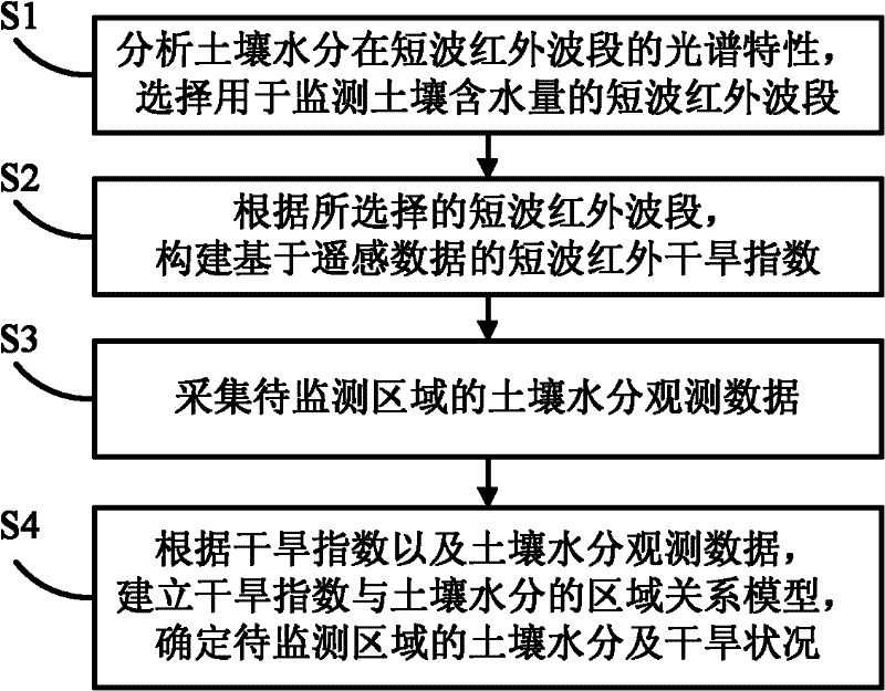
[0028] The soil water content remote sensing monitoring method proposed by the present invention is described in detail as follows in conjunction with the accompanying drawings and examples.
[0029] The Earth Observation System (EOS) series satellites are used to conduct atmospheric physical and chemical observations and land, hydrology, climate, and environmental surveys using satellite remote sensing technology, to obtain various comprehensive information on natural environmental resources more accurately, and to grasp the overall status of the earth's environmental resources and Its changing trend, the most important instrument on it is Moderate-resolution Imaging Spectroradiometer (MODIS, Moderate-resolution Imaging Spectroradiometer), its maximum spatial resolution can reach 250 meters, and the scanning width is 2330 kilometers. MODIS is a new generation of "map-integrated" optical remote sensing instrument in the world. It has 36 discrete spectral bands, including near-i...
PUM
 Abstract
Description
Claims
Application Information
 - R&D
- Intellectual Property
- Life Sciences
- Materials
- Tech Scout
- Unparalleled Data Quality
- Higher Quality Content
- 60% Fewer Hallucinations
Browse by: Latest US Patents, China's latest patents, Technical Efficacy Thesaurus, Application Domain, Technology Topic, Popular Technical Reports.
© 2025 PatSnap. All rights reserved.Legal|Privacy policy|Modern Slavery Act Transparency Statement|Sitemap|About US| Contact US: help@patsnap.com


