
Spatial information processing service composition method with dynamics

A technology of service composition and space, which is applied in the field of spatial information processing service composition, can solve problems such as not considering the combination dynamics, and achieve the effects of improving recall and precision, reducing complexity, and reducing uncertainty

Active Publication Date: 2012-07-18
WUHAN UNIV
View PDF0 Cites 0 Cited by
  • Summary
  • Abstract
  • Description
  • Claims
  • Application Information

AI Technical Summary

Problems solved by technology

Since the spatial information processing service and its combination are a new research direction in the rise of network geographic information systems in recent years, the existing combination methods still stay at the static combination of spatial information services using the network service composition language, without considering the combination dynamic

Method used


Image

  • Spatial information processing service composition method with dynamics
  • Spatial information processing service composition method with dynamics
  • Spatial information processing service composition method with dynamics

Examples


Embodiment Construction

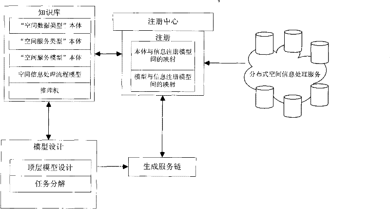
[0019] The present invention provides a spatial information processing service combination method based on process planning, which includes the following steps,

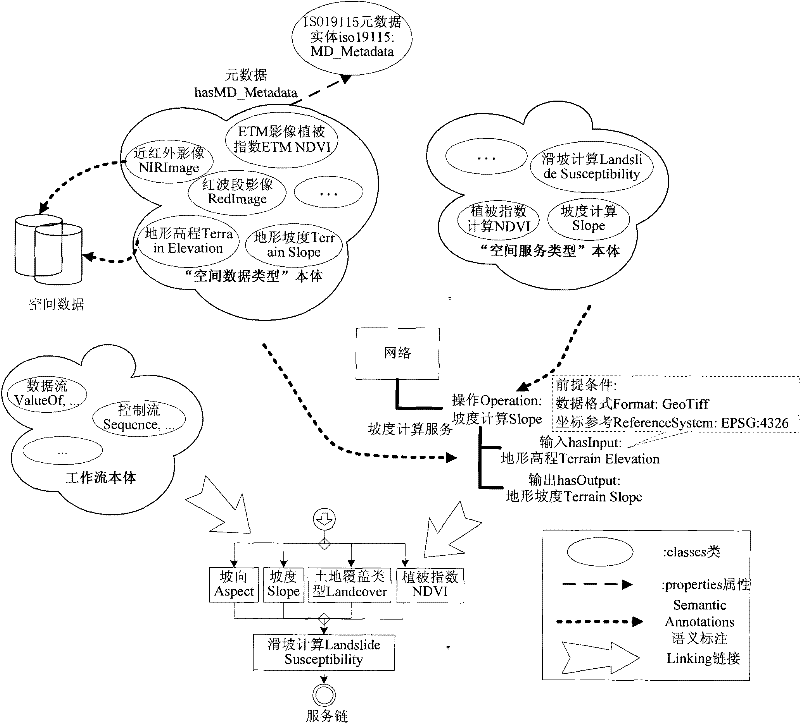
[0020] Step 1. Semantically describe the input and output, functions, preconditions and state changes of spatial information processing services based on the ontology description language OWL, and establish the "spatial data type" ontology and the "spatial service type" ontology. Based on the "spatial data type" ontology Create a "spatial service model" ontology with the "spatial service type" ontology.

[0021] Specifically, the semantic description of the input and output of the spatial information processing service is expressed by the entity class in the "spatial data type" ontology, and the semantic description of the function of the spatial information processing service is expressed by the entity class in the "spatial service type" ontology. The "spatial service model" ontology is a combined expression of the ...


PUM


Abstract

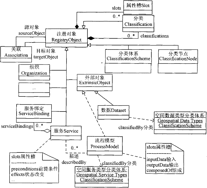
The invention provides a spatial information processing service composition method with dynamics. The method has the following beneficial effects: relations among spatial information processing services can be more accurately established through semantic matching on the basis of semantic descriptions of the spatial information processing services; by carrying out semantic extension on a catalog registration information unit model, search considering semantics can be realized, recall and precision of inquiry can be improved and the existing spatial information processing flow model knowledge can be managed and reused; a service model at high level is divided into limited service compositions at low level through task decomposition, thus reducing the search space, reducing the uncertainty of service composition and conducing to reducing the complexity of reasoning; and with dynamics and intelligence, the method is of great importance to extracting the information and knowledge needed bythe users from massive network data by intelligently constructing the spatial information processing flows in the environment of network-loaded massive information.

Description

technical field [0001] The invention belongs to the application field of network geographic information systems, and in particular relates to a spatial information processing service combination method. Background technique [0002] In recent years, service-oriented architecture SOA, as a new information architecture, has been gradually introduced into scientific application research. In the massive information environment carried by the network, if it is possible to intelligently search for and integrate spatial data and services, help users build complex spatial information processing procedures, and automatically or semi-automatically extract the information and knowledge users need from massive network data, it will be It makes geospatial information sharing and application services enter a new era, greatly meets the needs of society for public space information, and promotes the development of geospatial information science. In the field of general-purpose computers, t...

Claims


Application Information

Patent Timeline
Patent Type & Authority Patents(China)
IPC IPC(8): G06F17/30
Inventor 乐鹏龚健雅狄黎平
Owner WUHAN UNIV
Learn More