Multi-resolution modeling method for three dimensional model of complex building
A three-dimensional model, multi-resolution technology, applied in the field of geospatial information system, to achieve the effect of high execution efficiency, simplified visual continuity, and concise method
- Summary
- Abstract
- Description
- Claims
- Application Information
AI Technical Summary
Problems solved by technology
Method used
Image
Examples
Embodiment Construction
[0058] The technical scheme of the present invention is described in detail below in conjunction with accompanying drawing:
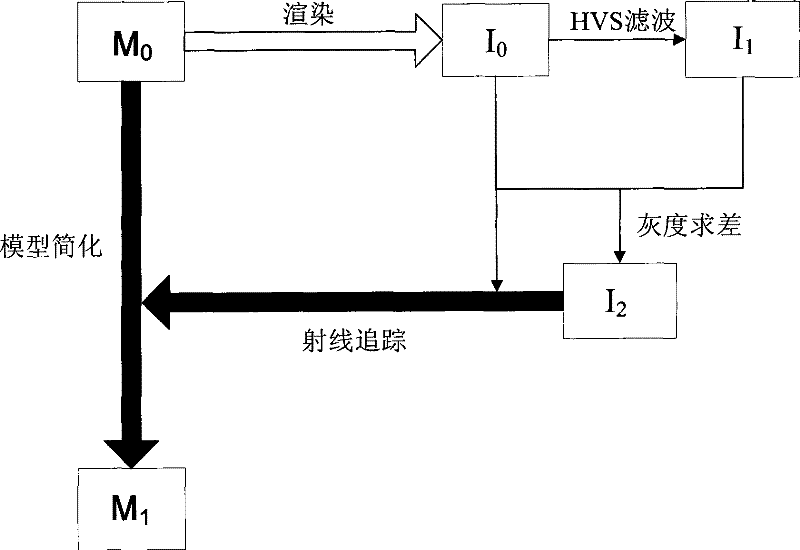
[0059] see figure 1 , the principle of the technical solution of the present invention is to simplify the three-dimensional model M of the original building 0 , the original rendered image I is obtained through the mapping process of object space and image space 0 ; Then carry out the process of image space processing, from the original rendered image I 0 Get Perceptually Reconstructed Image I 1 , the original rendered image I 0 and perceptual image I 1 Find the difference to obtain the difference image I 2 ;Final difference image I 2 Inversely map to the object space, output the simplified model data, and visualize the 3D simplified model M of complex buildings 1 , to complete the object space simplification process.
[0060] The implementation process of the embodiment of the present invention uses a computer to realize automatic processing, ...
PUM
 Abstract
Description
Claims
Application Information
 - Generate Ideas
- Intellectual Property
- Life Sciences
- Materials
- Tech Scout
- Unparalleled Data Quality
- Higher Quality Content
- 60% Fewer Hallucinations
Browse by: Latest US Patents, China's latest patents, Technical Efficacy Thesaurus, Application Domain, Technology Topic, Popular Technical Reports.
© 2025 PatSnap. All rights reserved.Legal|Privacy policy|Modern Slavery Act Transparency Statement|Sitemap|About US| Contact US: help@patsnap.com


