
River time series analysis system and method based on spatial image information and gis

A time series analysis, spatial image technology, applied in geographic information database, measurement of the movement of open water sources, structured data retrieval, etc.

Inactive Publication Date: 2011-12-21
仁荷大学教产学协力团
View PDF1 Cites 0 Cited by
  • Summary
  • Abstract
  • Description
  • Claims
  • Application Information

AI Technical Summary

Problems solved by technology

However, the patent disclosed in Patent Document 2 also has the problem that it cannot be flexibly used in government offices for river maintenance and river planning decisions by simply warning the danger of dam facilities. In the case of monitoring the water level of a dam and notifying the degree of danger, more variables and data must be required to establish the government office and river maintenance and river planning correctly only by obtaining a very indirect correlation with the river maintenance and river planning problems of comparison and analysis

Method used


Image

  • River time series analysis system and method based on spatial image information and gis
  • River time series analysis system and method based on spatial image information and gis
  • River time series analysis system and method based on spatial image information and gis

Examples


Embodiment Construction

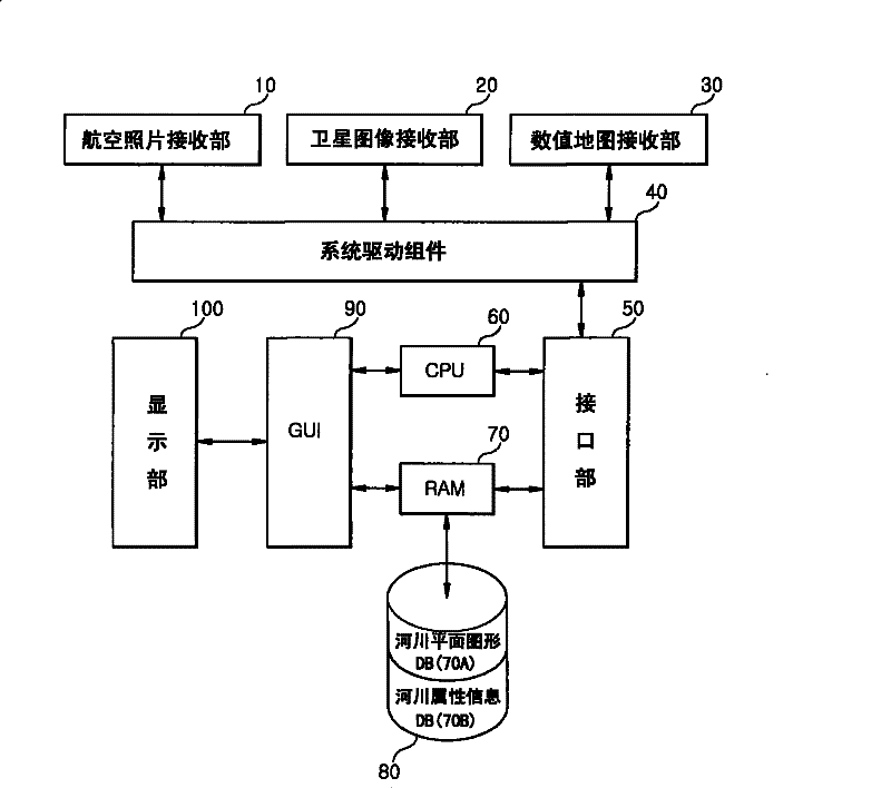
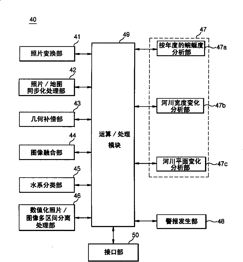
[0022] The present invention will be specifically described below with reference to the accompanying drawings.

[0023] figure 1 It is a block diagram showing the structure of the river time series analysis system based on spatial image information and GIS of the present invention, figure 2 It is a block diagram showing the structure of the system driving components included in the river time series analysis system based on spatial image information and GIS according to an embodiment of the present invention.

[0024] Referring to these drawings, a river time-series analysis system based on spatial image information and GIS according to an embodiment of the present invention is a system in which actual coordinate values ​​are set in yearly aerial photographs of target rivers such that Satellite images by year go through precise geometric compensation, image fusion, and water system classification in the target area. Then, based on the aerial photos and satellite images using...


PUM


Abstract

The invention provides a method for analyzing spatial image information and GIS based river time sequence, comprising forming low waterway and dike data in each year according to aerial photographs and satellite images of coordinates, automatically and systematically processing river level change analysis and plane shape change in each year, and easily comparing the moving of the low waterway. The system comprises a display part, a database, and a system drive component; the control manner is as follows: receiving aerial photographs, satellite images and a digital map; changing the resolutions and capacities of the aerial photographs; synchronizing the coordinates with the aerial photographs; performing geometrical compensation and image fusion on the satellite images and classifying the aquo system of the target region, dividing the river areas of the aerial photographs and satellite images of the region into a plurality of areas in each year, comparing the change of the river, and driving to alarm when the area change is judged.

Description

technical field [0001] The present invention relates to a river time series analysis system and method based on spatial image information and GIS. More specifically, the present invention relates to setting actual coordinate values ​​in the annual aerial photographs of the target river, so that the annual satellite photographs After undergoing precise geometric compensation, image fusion, and water system classification in the target region, the photos of low waterways (river courses below the full water level) and embankments are automatically compared on an annual basis, so that spatial image information and decision-making data can be quickly obtained. GIS river time series analysis system. Background technique [0002] As well-known, the river course maintenance of the river maintenance currently practiced is carried out centering on size while ignoring the characteristics of the river flow. As a result, the artificial treatment of rivers is still going on today. Theref...

Claims


Application Information

Patent Timeline
Patent Type & Authority Patents(China)
IPC IPC(8): G06F17/30G06Q50/26G01C13/00
CPCY02A90/30G01C13/002G06F3/14G06F16/29G06Q50/26
Inventor 金桂炫
Owner 仁荷大学教产学协力团
Learn More