
Method and system matching with mobile phone for automatic navigation

An automatic navigation and mobile phone technology, applied in the field of navigation, can solve problems such as hidden safety hazards and troubles, and achieve the effects of good user experience, less trouble, and safe manipulation.

Inactive Publication Date: 2008-11-19
CARELAND TECH SHENZHEN
View PDF0 Cites 16 Cited by
  • Summary
  • Abstract
  • Description
  • Claims
  • Application Information

AI Technical Summary

Problems solved by technology

[0012] The technical problem to be solved by the present invention is to provide a method for automatically navigating with a mobile phone in view of the defect that the navigation system of the prior art is cumbersome and has potential safety hazards when manually inputting the navigation destination during driving.

Method used


Image

  • Method and system matching with mobile phone for automatic navigation
  • Method and system matching with mobile phone for automatic navigation
  • Method and system matching with mobile phone for automatic navigation

Examples


Embodiment Construction

[0037] Along with the development of mobile phone and navigation technology, there are a large number of mobile phones with navigation function now, and the mobile phones with navigation function are all equipped with GPS receiving module. The idea of ​​the present invention is that when a driving user communicates with a user holding a mobile phone with a GPS receiving module, the mobile phone automatically transmits its positioning information to the vehicle navigation system, and the navigation system performs automatic navigation based on the above positioning information.

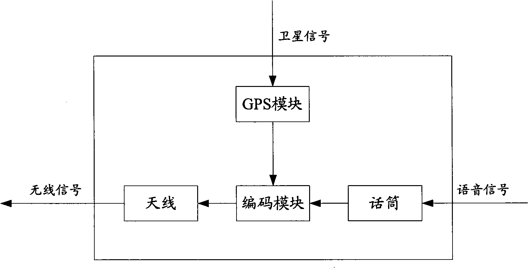
[0038] see figure 2 , is a module diagram of the mobile phone terminal (also called the first user mobile phone) of the automatic navigation system used in conjunction with the mobile phone in the present invention. When the mobile terminal user communicates with the vehicle terminal, the mobile phone receives satellite signals through the GPS module to obtain the positioning information of its curren...


PUM


Abstract

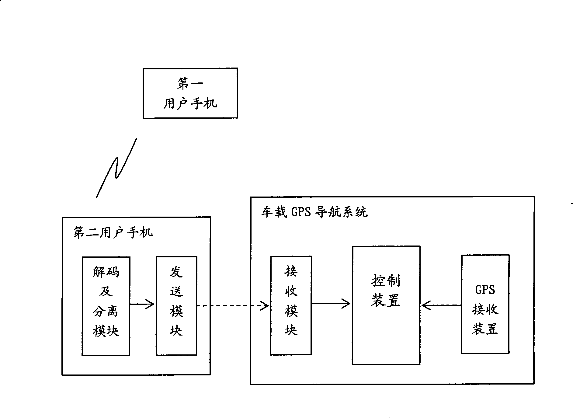
The invention relates to a method of automatic navigation by matching mobile phones and a system thereof comprising: a first user mobile phone with the GPS navigation function which receives and positions first positioning information of the current location of the first user mobile phone from a GPS satellite, implements coding processing and transmits a coded signal via an antenna; and a second user mobile phone which receives the coded signal sent by the first user mobile phone, and implements the decoding processing and separates out the first positioning information; the second user mobile phone transmits the separated first positioning information to a car GPS navigational system; and the car GPS navigational system receives the first positioning information from the second user mobile phone and receives second positioning information of the current location of a positioned vehicle from the GPS satellite, and carries out the automatic navigation operation by taking the first positioning information as navigation destination positional information and the second positioning information as departure place positional information. The navigation information can be obtained conveniently and safely by using the method and system of the invention and matching mobile phone operations by drivers without inputting the navigation destination manually.

Description

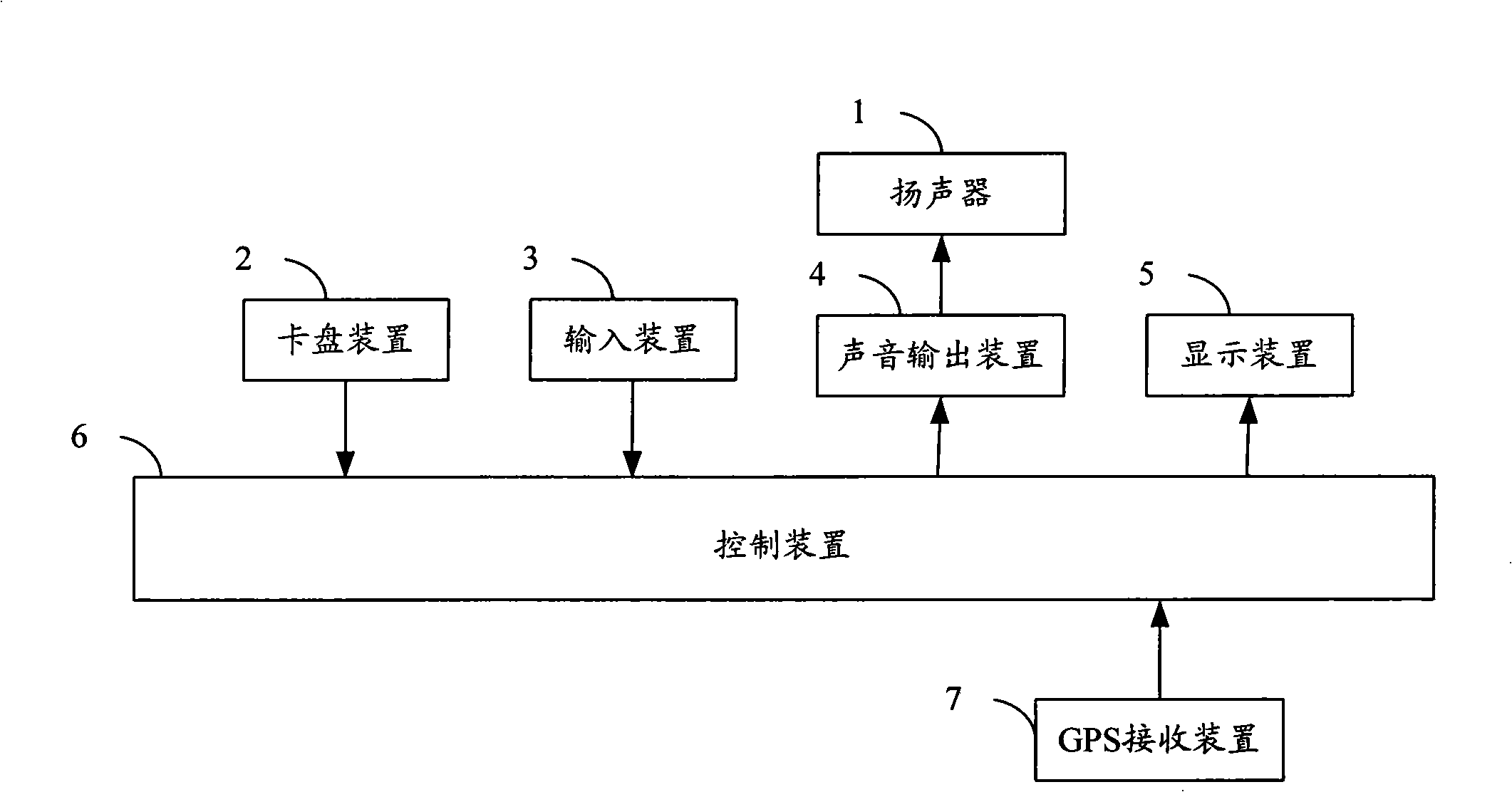
technical field [0001] The invention relates to navigation technology, more specifically, to a method and system for automatic navigation in cooperation with a mobile phone. Background technique [0002] Currently, the vehicle-mounted global positioning system (Global Positioning System, GPS) is one of the important application directions of GPS navigation. The GPS antenna of the vehicle-mounted GPS navigation system receives the data information transmitted by at least 3 of the 24 GPS satellites around the earth, combined with the electronic map stored in the vehicle-mounted navigation terminal, the position coordinates determined by the GPS satellite signal match this , to determine the exact position of the navigation object in the electronic map. The user driving the vehicle can let the computer select the driving path while driving, and use this as the direction guide, so as to reach the destination correctly and quickly. [0003] figure 1 It is a structural diagram ...

Claims


Application Information

Patent Timeline
IPC IPC(8): G01C21/26G01C21/34G01C21/36H04Q7/32
Inventor 张文星
Owner CARELAND TECH SHENZHEN
Learn More