Method and device for predicting high and displaying same

A technology of altitude and indication, applied in the field of avionics, can solve the problem of wrong red zone, etc., achieve the effect of accurate terrain display, high precision, and avoid dangerous situations

Inactive Publication Date: 2012-01-04
SANDEL AVIONICS
View PDF1 Cites 0 Cited by
  • Summary
  • Abstract
  • Description
  • Claims
  • Application Information

AI Technical Summary

Problems solved by technology

For example, if the aircraft is climbing, the above prior art altitude display may falsely report the presence of a red zone

Method used


Image

  • Method and device for predicting high and displaying same
  • Method and device for predicting high and displaying same
  • Method and device for predicting high and displaying same

Examples


Embodiment Construction

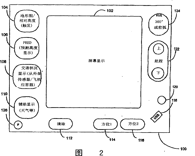
[0030] see figure 2 , the present invention may include a display device 100 of a terrain sensing (TAWS) system shown in the figure. Display device 100 employs a screen display 102, which may be an LCD rear-projection screen of the type disclosed in U.S. Patent 6,259,378 (owned by the assignee of the present invention), which is incorporated herein by reference in its entirety . The display device 100 further includes a plurality of buttons and interfaces surrounding the perimeter.

[0031] An exemplary layout of the display device will now be described. However, it is obvious that the specific button and functional arrangement described below is only an example, and the present invention is not limited thereto.

[0032] When the trigger button 104 is pressed, the screen display can be toggled between a terrain display and a relative altitude display. When the Predicted Altitude Display ("PRED") button 106 is pressed, the screen display 102 becomes a PRED display, as will ...


PUM


Abstract

This invention provides a method and its equipment for instructing aircraft the height relative to the obstructions in a terrain detection alarm system. It receives the data and gives instructions including the obstacles terrain, the aircraft's horizontal distance from the terrain, the aircraft altitude and the aircraft flight path. Calculate the projection height of the aircraft on the position of the obstacle by using the above data and produce the final signal based on which display the color signage in screen. The equipment includes not only signal input, which signals are from the measured aircraft height, flight routes and the location, but also instrument input which provide the information of the topography surrounding the aircraft. Besides above, the equipment includes a device which calculates the effective height compared to the terrain by using the above signal, and a screen display which uses the chart to show the results.

Description

[0001] This application is a divisional application of an invention patent application with the filing date of October 11, 2001, the application number of 01820318.3, and the invention title of "Method and Device for Predictive Altitude Display". [0002] This application is a continuation-in-part of U.S. Provisional Patent Application Serial No. 60 / 239,319, filed October 10, 2000, and entitled "Terrain Sensing and Warning System (TAWS)," which is incorporated herein by reference in its entirety way to combine. technical field [0003] The present invention relates to avionics, and more particularly to altitude displays and terrain detection and warning systems. Background technique [0004] Traditional altitude displays used in Terrain Awareness Warning Systems (TAWS) on existing aircraft provide the pilot with a visual display of terrain that is above the aircraft and within a certain distance (typically 2000' below the aircraft) of the aircraft. terrain. [0005] Referr...

Claims


Application Information

Patent Timeline
Patent Type & Authority Patents(China)
IPC IPC(8): G01C5/00G01S7/06G01S13/93G01S13/91G08G5/02G08G5/04
Inventor G・J・布劳克
Owner SANDEL AVIONICS
Why Eureka
Try Eureka