Eureka AIR delivers breakthrough ideas for toughest innovation challenges, trusted by R&D personnel around the world.

Method and apparatus for multi-mode tracking and display of personnel locations in a graphical model

a graphical model and multi-mode technology, applied in the field of building construction, can solve the problems of limited manpower, lack of real-time location, expertise and other attributes of construction workers while they are on-site, and no one tracking technology provides the dependability required to efficiently and reliably track and identify construction workers

Active Publication Date: 2015-02-26
SPECIALTY ELECTRICAL
View PDF1 Cites 69 Cited by
  • Summary
  • Abstract
  • Description
  • Claims
  • Application Information

AI Technical Summary

Benefits of technology

The patent describes a system that uses radio waves to track people in real-time within concrete and steel structures. This system is synchronized with a GPS system to provide accurate location data. The system allows for the display of workers' locations and the coordination of those locations with a BIM graphic model system. This helps to better visualize and manage workers' locations in real-time.

Problems solved by technology

Participants in the construction industry are constantly challenged to deliver successful projects despite tight budgets, limited manpower, accelerated schedules, and limited or conflicting information.
Despite its advantages, the BIM concept of the prior art lacks the ability to track the real time location, expertise and other attributes of construction workers while they are on-site.
Applicant has also realized that no one tracking technology provides the dependability required to efficiently and reliably track and identify construction workers in a “live” building construction project.
For example, large moving steel equipment, concrete, construction barriers, walls and high current electric devices such as air handlers and generators present on a live construction site all interfere to some degree with different tracking technologies at different times leading to failure.
Data is actually sent at a much lower rate, which limits the accuracy of the signal.
Civilian GPS devices provide latitude and longitude information, but, are not considered sufficiently accurate or continuously available enough (due to the possibility of signal blockage and other factors) to rely on exclusively to transmit highly accurate location information over a wide range of building construction equipment due primarily to interference from concrete and steel structures.
The prior art has attempted several piecemeal solutions using either RFID or GPS, but none have attempted to combine positioning systems with a BIM model or other 3-D construction modeling systems and none have been completely satisfactory.
But, Cummings, et al. do not disclose a way to integrate the RFID tag with a BIM model.
Di Floriano lacks the means or necessary systems to precisely track location, having only the ability to ascertain if a person carrying an RFID device is inside the targeted area.
However, Werb does not disclose a way to input location information into a BIM system or to compensate for problems caused by obstructions on a construction site which interfere with the locating system.
RFID tags are used to analyze the location of the object and its status as “installed” or “uninstalled.” However, Broughton does not disclose a way to integrate location information of personnel or construction workers into a BIM model nor does it provide a way to track or avoid constantly moving items (like workers) and compensate for building construction obstructions.

Method used


Image

  • Method and apparatus for multi-mode tracking and display of personnel locations in a graphical model
  • Method and apparatus for multi-mode tracking and display of personnel locations in a graphical model
  • Method and apparatus for multi-mode tracking and display of personnel locations in a graphical model

Examples


Embodiment Construction

[0044]It will be appreciated by those skilled in the art that aspects of the present disclosure may be illustrated and described herein in any of a number of patentable classes or context including any new and useful process, machine, manufacture, or composition of matter, or any new and useful improvement thereof. Therefore, aspects of the present disclosure may be implemented entirely in hardware, entirely in software (including firmware, resident software, micro-code, etc.) or combining software and hardware implementation that may all generally be referred to herein as a “circuit,”“module,”“component,” or “system.” Further, aspects of the present disclosure may take the form of a computer program product embodied in one or more computer readable media having computer readable program code embodied thereon.

[0045]Any combination of one or more computer readable media may be utilized. The computer readable media may be a computer readable signal medium or a computer readable storag...


PUM


Abstract

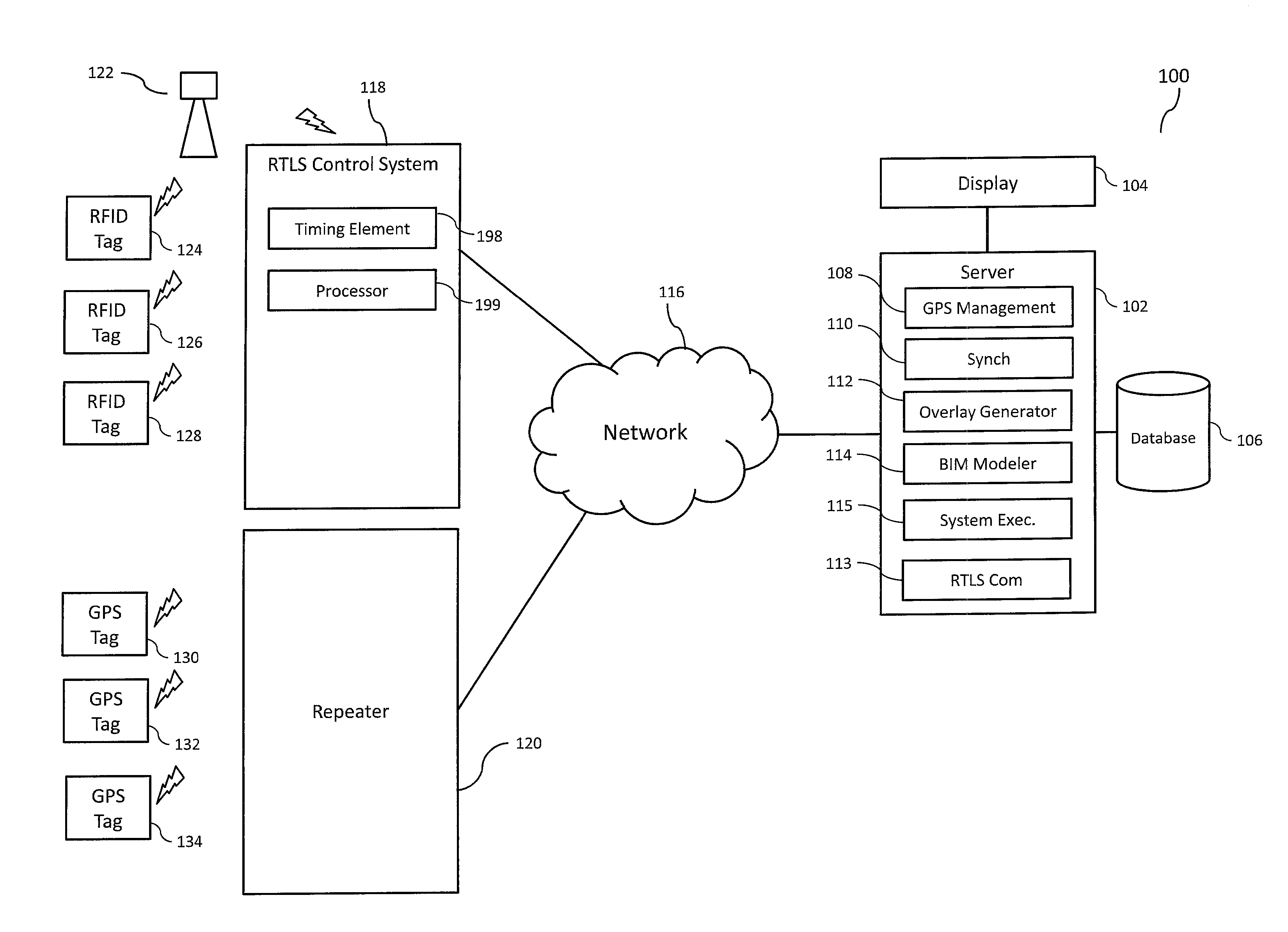
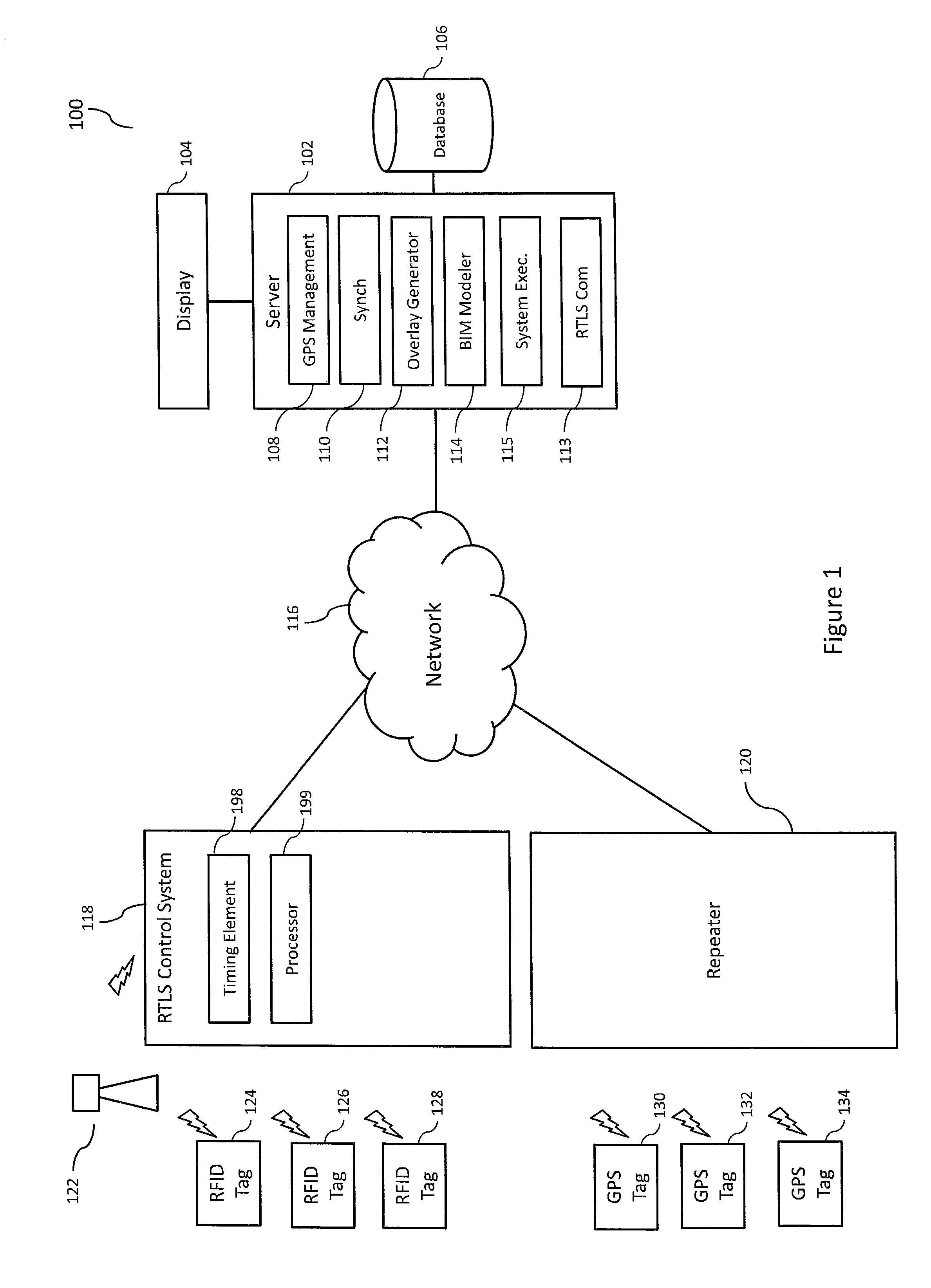
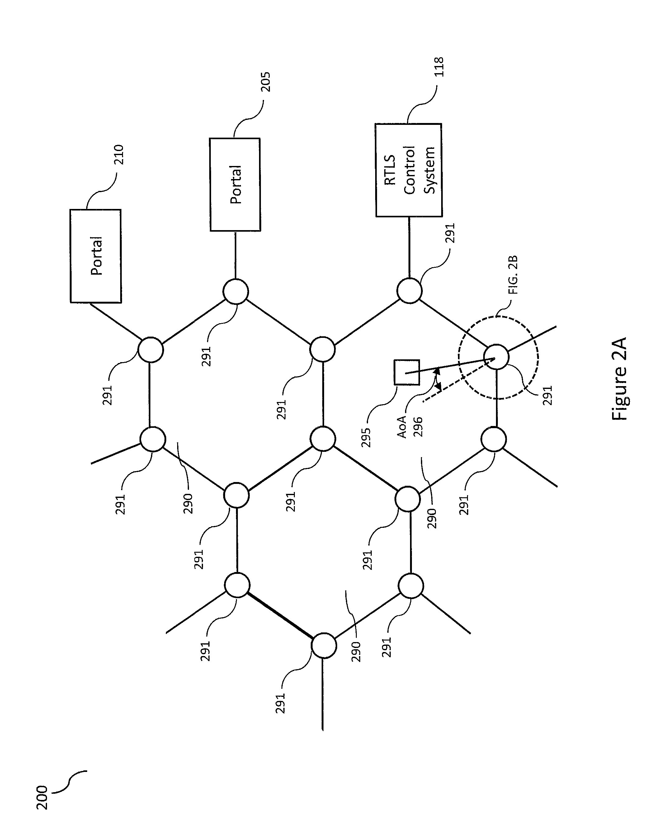
The preferred embodiment provides an ultra-wide band radio frequency real-time location system (RTLS), synchronized with a GPS location system to provide reliable location data, in and around concrete and steel superstructures to a BIM graphic model system, to gather and display worker location data and coordinate its display for use. The RTLS system continuously locates each participant through the use of an active RFID tag and / or GPS location device, which may be placed in a personnel badge and verified. The location system logs the participant locations in a database for real-time information retrieval and upload into a BIM display system.

Description

FIELD OF THE INVENTION[0001]The present invention relates to the building construction field. More specifically, the invention relates to integration of personnel tracking technologies into computer aided design software to identify the location and descriptions of construction workers.BACKGROUND OF THE INVENTION[0002]Participants in the construction industry are constantly challenged to deliver successful projects despite tight budgets, limited manpower, accelerated schedules, and limited or conflicting information. The significant disciplines such as architectural, structural and plumbing and electrical must be coordinated to ensure efficiency.[0003]In the past, traditional building design was largely reliant upon two-dimensional drawings (plans, elevations, sections, etc.). However, modern building techniques include electronic building information modeling (BIM). BIM extends traditional building design beyond two dimensional drawings by providing electronic display of projects i...

Claims


Application Information

Patent Timeline
IPC IPC(8): G06F17/50
CPCG06F17/5004G01S19/48G01S5/06G07C9/28G06F30/13
Inventor GROSS, SCOTTY RAY
Owner SPECIALTY ELECTRICAL
Why Eureka
Eureka Blog
Learn More