Method of calculating TAVI based on a band ratio model and solar altitude angle

a band ratio model and solar altitude angle technology, applied in the field of calculating a tavi based on a band ratio model and a solar altitude angle, can solve the problems of limited application of promoted methods within a large range, affecting reducing the accuracy of vegetation information, so as to achieve accurate inversion and convenient application. , the effect of reducing the difficulty of calculating

Active Publication Date: 2020-01-07
FUZHOU UNIV
View PDF9 Cites 0 Cited by
  • Summary
  • Abstract
  • Description
  • Claims
  • Application Information

AI Technical Summary

Benefits of technology

[0013]In view of this, an objective of the present invention is to provide a method of calculating a TAVI based on a band ratio model and a solar altitude angle. According to the method, a new, more stable SVI is constructed based on the basic principle of the band ratio model and RVI is preferred for combinational calculation with the new SVI, so that the TAVI algorithm can be more accurate and more convenient in application. What is more, a new algorithm of an adjustment factor f(Δ) based on a solar altitude angle is proposed, which does not need DEM data and remote sensing image classification, and is independent of ground survey data with practical physical significance, and has Important scientific significance and economic value for large-range application promotion of the TAVI for accurate inversion of the vegetation information of complex topographic mountainous areas.
[0022]The present invention has the following advantages when compared to the prior art:
[0023]1. More definite physical significance and simpler calculation: the new TAVI combinational algorithm is composed of two submodels RVI and SVI, both of which can meet the requirements of the band ratio model and are simple and similar in form. Moreover, the two submodels may have a better band ratio physical significance footing because their denominators are both red-band data of a remote sensing image. Moreover, the adjustment factor f(Δ) is calculated with a solar altitude angle, which may have definite physical significance. Additionally, the new method of calculating a TAVI is simpler in overall calculation flow, allowing a great improvement in the automation level of TAVI application.
[0024]2. Significant topographic correction results: the method of calculating a TAVI determined in the present invention ensures that the interference of the topographic effects with the vegetation information can be effectively eliminated by the TAVI. By utilizing Landsat multispectral remote sensing image data of different time phases in FIG. 1 of a research area (including Ladsat5 TM and Ladsat8 OLI image data), it indicates that the present invention can ensure that the mean values of the absolute values of the correlation coefficients for TAVIs of the Ladsat5 TM and Ladsat8 OLI Images of different time phases and cosine values (cosi) of solar incident angles are lower than 0.1 (table 1). That is, the TAVI is superior to other common vegetation indices and even better in results than the NDVI of the DEM-based C correction image calculation (FIG. 1).
[0027]3. Low data requirements and low costs: the present invention only needs the band data and solar altitude angle data carried in a remote sensing image itself with no need for the support of DEM data, ground survey data, on-the-spot investigation data or the like, thereby minimizing the data costs and the time costs.

Problems solved by technology

In a complex topographic mountainous area, the solar radiation distribution on the surface of the mountainous area may change under topographic effects, so that the radiance value of a mountain's shady slope area of a remote sensing image decreases while the radiance value of a sunny slope area increases, leading to severe problems such as “the same object with different spectra” and “the same spectrum with different objects”.
Therefore, diluting the topographic effects has become an important problem confronting the remote sensing of vegetation in complex topographic mountainous areas.
However, these methods may have a problem of overcorrection because the effects of atmospheric scattered radiation and adjacent topography reflected radiation are not taken into account.
Moreover, the promoted application of such method within a large range is restricted due to such problems as accuracy and availability (such as security restrictions, long data update cycle, and the like) of high-accuracy DEM data, registration accuracy between DEM and a remote sensing image.
Such a method can eliminate the effects of direct solar radiation, atmospheric scattered radiation and adjacent topography reflected radiation in a remote sensing image due to complex topography in theory, but promoted application of the models is restricted by complex model parameters and great difficulty in obtaining desired parameter data.
Such models have no requirement on additional input data and are a special vegetation index to a particular extent, but are unstable in application results.
With regard to the combinational algorithm, due to a great number of CVIs, confusion may be easily caused in the absence of a uniform standard for which a special vegetation index is selected during practical application.
The numerator of the SVI algorithm is a variable, resulting in instability of the SVI calculation results.
Therefore, the existing combination form of the RVI and SVI has great uncertainty, which affects the large-range promoted application of the TAVI.
The above two methods of calculating f(Δ) can effectively dilute the effects of topography on mountainous vegetation information with no need for support of data such as DEM; but the two optimization algorithms are relatively weak in physical significance because they depend on considerable experience and both require classification of a remote sensing image.
In addition, the algorithm of optimization matching further needs support of ground data and the like, and the algorithm of optimization of extrema is prone to local optimization rather than global optimization.
All of these limit the automation application level of the TAVI and are not good for the large-range promoted application of the TAVI.

Method used


Image

  • Method of calculating TAVI based on a band ratio model and solar altitude angle

Examples


Embodiment Construction

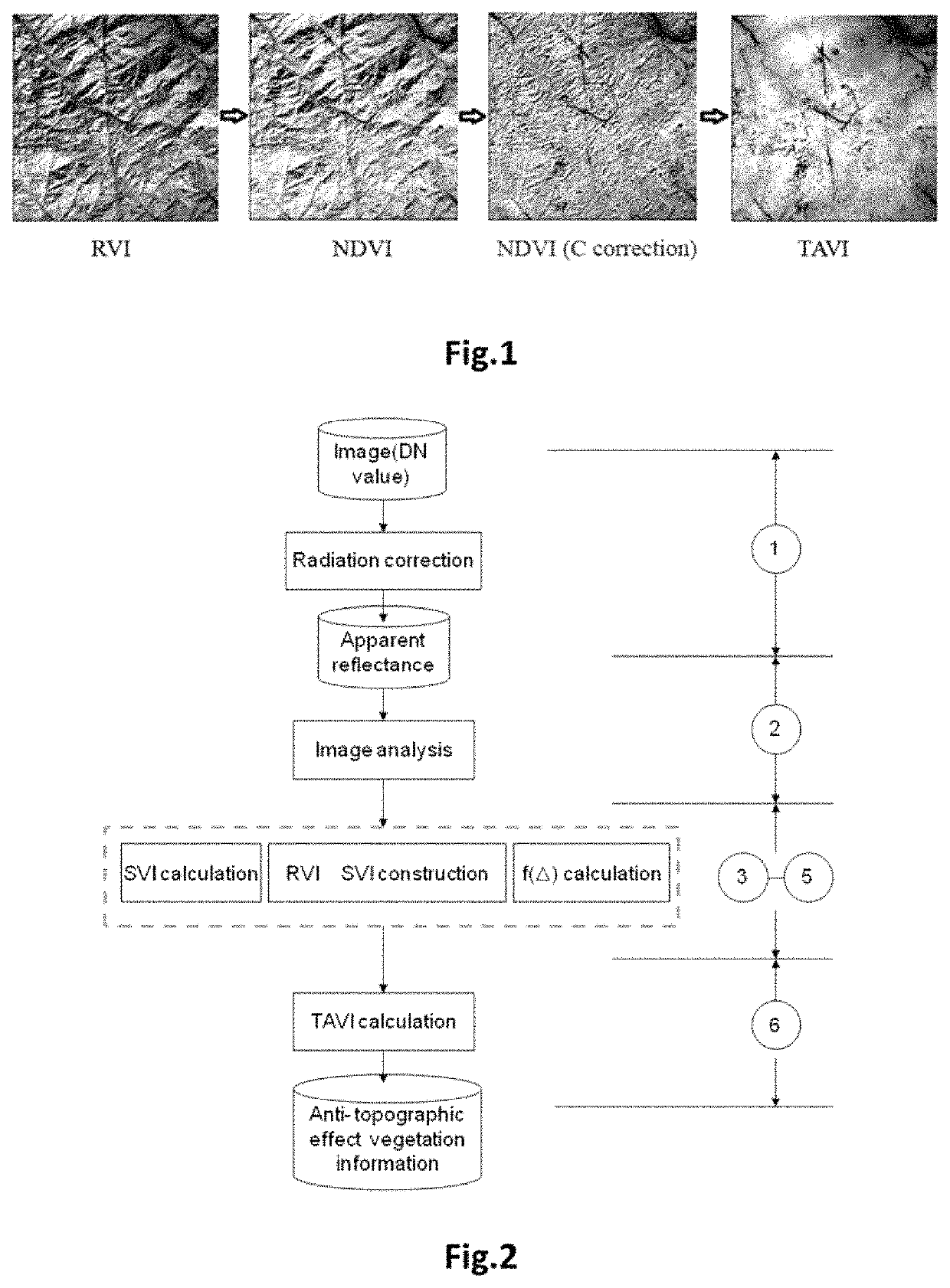
[0032]The present invention will be further described below in conjunction with the accompanying drawings and an embodiment.

[0033]Referring to FIG. 2, the present disclosure provides a method of calculating a Topography Adjusted Vegetation Index (TAVI) based on a band ratio model and a solar altitude angle. The method includes the following steps.

[0034]At step S1, image preprocessing is performed, which specifically includes: performing radiation correction on a multi-spectral remote sensing image to generate apparent reflectance data of the image.

[0035]At step S2, the quality of the image is analyzed, which specifically includes: determining the apparent reflectance data of a red band and a near-infrared band of the remote sensing image (calculating mean values, mid-values, variances and other indices of the two bands) and analyzing whether the reflectance of mountainous vegetation is reasonable at the two bands to decide whether the image is normally available.

[0036]At step S3, a ...


PUM

PropertyMeasurementUnit
solar altitude angleaaaaaaaaaa
apparent reflectanceaaaaaaaaaa
reflectanceaaaaaaaaaa

Abstract

The present invention relates to a method of calculating a Topography Adjusted Vegetation Index (TAVI) based on a band ratio model and a solar altitude angle. The method includes the following steps: obtaining the apparent reflectance data of a remote sensing image through image preprocessing, analyzing the quality of the image and numerical distribution, calculating a Shadow Vegetation Index (SVI), and constructing a TAVI combinational algorithm:TAVI=BirBr+f⁡(Δ)·1Br,calculating an adjustment factor f(Δ) with the solar altitude angle, and finally obtaining anti-topographic effect TAVI vegetation information. The TAVI in the present invention is composed of two band ratio submodels RVI and SVI, the denominators of both of which are red band data of a remote sensing image, and the adjustment factor f(Δ), which is calculated by a solar altitude angle as a parameter with a sensor factor applied, has great physical significance. The TAVI calculation method does not need digital elevation model (DEM) data and remote sensing image classification when not depending on ground survey data, and ensures that the interference of the topographic effects with the vegetation information can be effectively eliminated by the TAVI, thereby avoiding the problem of reduced inversion accuracy of ground vegetation information due to different registration accuracy of a remote sensing image and DEM data.

Description

BACKGROUND OF THE INVENTION1. Technical Field[0001]The present invention relates to a method of calculating a TAVI based on a band ratio model and a solar altitude angle.2. Description of Related Art[0002]In a complex topographic mountainous area, the solar radiation distribution on the surface of the mountainous area may change under topographic effects, so that the radiance value of a mountain's shady slope area of a remote sensing image decreases while the radiance value of a sunny slope area increases, leading to severe problems such as “the same object with different spectra” and “the same spectrum with different objects”. The accuracy of the inversion of the relevant biological parameters of a mountain's vegetation by a conventional remote sensing method for the vegetation index may be reduced accordingly. Therefore, diluting the topographic effects has become an important problem confronting the remote sensing of vegetation in complex topographic mountainous areas.[0003]The f...

Claims


Application Information

Patent Timeline
Patent Type & Authority Patents(United States)
IPC IPC(8): G06K9/00G01N21/3563G01N21/17G01N21/359
CPCG01N21/3563G01N21/359G06K9/00657G01N2021/1797G01N2021/1793G06V20/188
Inventor JIANG, HONGWANG, XIAOQINCHEN, CHONGCHENG
Owner FUZHOU UNIV
Why Eureka
Try Eureka