
Online classification system and method based on multi-source remote sensing application data

A technology that applies data and classification methods. It is applied in the field of satellite remote sensing. It can solve problems such as large errors in data analysis range classification results, customized products that do not meet user needs, and difficult to expand system update algorithms. It achieves easy expansion, large data volume, and type many effects

Pending Publication Date: 2022-05-13
中科星通(廊坊)信息技术有限公司
View PDF4 Cites 0 Cited by
  • Summary
  • Abstract
  • Description
  • Claims
  • Application Information

AI Technical Summary

Problems solved by technology

However, my country's existing remote sensing, navigation, and communication satellite systems are divided into systems, military and civilian isolation, information separation, and service lag. The volume is increasing, users in different fields and levels have more and more demand for remote sensing application data, and users such as regions (smart cities), industry informatization, and the general public are demanding full-scale, near-real-time communication and in-depth application of remote information. The demand for industrialization development is also becoming stronger
[0003] Existing online classification methods based on multi-source remote sensing application data must select production data, algorithms, and

Method used


Image

  • Online classification system and method based on multi-source remote sensing application data
  • Online classification system and method based on multi-source remote sensing application data
  • Online classification system and method based on multi-source remote sensing application data

Examples


Example Embodiment

[0150] Embodiment 1: Set the remote sensing image slice threshold to 1000*1000, the size of the satellite remote sensing image to be processed is 2000*3000, and the longitude and latitude coordinates of the four points of the satellite remote sensing image to be processed are (4, 4), (8, 4), (8, 0), (4, 0);

[0151]

[0152] Then the remote sensing image needs to be sliced;

[0153] The number of transverse slices W is:

[0154]

[0155] The number of longitudinal slices C is:

[0156]

[0157] The abscissas of the slices are:

[0158] x11=x1=4;

[0159]

[0160]

[0161] The vertical coordinates of the slice are:

[0162] y11=y1=4;

[0163]

[0164]

[0165] Then the corresponding horizontal slice coordinates of the remote sensing image are: (4, 4), (6, 4), (8, 4).

Example Embodiment

[0166] Embodiment 2: The selected algorithm model also includes a stack denoising autoencoder, a BP neural network classification algorithm, a minimum distance classification algorithm and a support vector machine algorithm;

[0167] Stacked denoising autoencoder:

[0168] Build a stacked denoising autoencoder model. The model is composed of multiple basic constituent units DAE stacked, and the shallow network is built into a deep network by stacking. The stacked denoising autoencoder includes two processes: encoding and decoding, The role of the encoder is to map the input data to the hidden layer to obtain a new feature representation, and the role of the decoder is to map the mapped data of the hidden layer back to the original input data

[0169] The stack denoising autoencoder model automatically analyzes the spectral statistical measurement parameters of each feature type, and identifies the feature category of each pixel in the image to be processed. The specific method...


PUM


Abstract

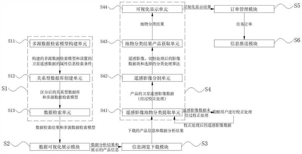
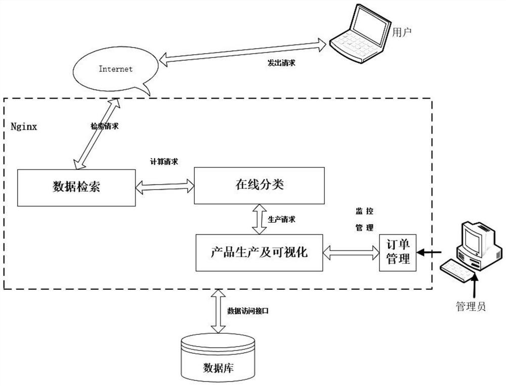
The invention discloses an online classification system and method based on multi-source remote sensing application data, and belongs to the technical field of satellite remote sensing. The method comprises the following steps of 1, constructing a multi-source data retrieval model based on space and elements, directly positioning remote sensing image data meeting requirements according to the model, and quickly and accurately obtaining metadata information; 2, performing two-dimensional visualization on the online customized product of the user, analyzing the product data information of the online customized product in a time sequence analysis and space analysis mode, and performing online analysis and visual display on the product data information by using a scatter diagram, a pie chart and a histogram; 3, the user with the browsing and downloading authority browses and downloads the product data of the customized product meeting the actual requirements of the user in the step 2 by means of a related view button and a related tool; and 4, calling an online classification algorithm to perform online processing on the satellite remote sensing image according to the product information downloaded by the user in the step 3.

Description

technical field [0001] The invention relates to the technical field of satellite remote sensing, in particular to an online classification system and method based on multi-source remote sensing application data. Background technique [0002] Since the development of space remote sensing research in our country, satellite remote sensing technology has developed vigorously, and the categories of satellite systems have been gradually enriched, and a military and civilian application system with a certain scale and extensive degree has been formed. Satellite applications are developing in depth and comprehensively, and the industrial scale is increasing year by year. However, my country's existing remote sensing, navigation, and communication satellite systems are divided into systems, military and civilian isolation, information separation, and service lag. The volume is increasing, users in different fields and levels have more and more demand for remote sensing application dat...

Claims


Application Information

Patent Timeline
IPC IPC(8): G06F16/51G06F16/53G06F16/54G06F16/55
CPCG06F16/51G06F16/53G06F16/54G06F16/55Y02P90/30
Inventor 王栋杨静静臧文乾黄祥志米晓飞扈子豪刘瑞云赵会军
Owner 中科星通(廊坊)信息技术有限公司
Learn More