Method and device for establishing and identifying landslide classification model in complex background area

A technology for classifying models and establishing methods, applied in scene recognition, character and pattern recognition, instruments, etc., can solve problems such as lack of robust sensitive feature subsets, restricting the accuracy of landslide remote sensing recognition, and inability to optimize data sets, so as to improve accuracy and effectiveness, and the effect of improving the accuracy of landslide remote sensing identification.

Active Publication Date: 2021-02-26
CHINA UNIV OF GEOSCIENCES (WUHAN)
View PDF10 Cites 0 Cited by
  • Summary
  • Abstract
  • Description
  • Claims
  • Application Information

AI Technical Summary

Problems solved by technology

[0002] In the prior art, in the field of landslide remote sensing recognition, the problem of class imbalance has not attracted enough attention. There are two problems in the learning method of remote sensing class imbalance: (1) lack of an effective method for optimizing the balance coefficient, resulting in the inability to obtain the optimal (2) Lack of robust sensitive feature subsets after class balance, unable to provide optimized data sets for subsequent classification
These problems further restrict the improvement of landslide remote sensing recognition accuracy.

Method used


Image

  • Method and device for establishing and identifying landslide classification model in complex background area
  • Method and device for establishing and identifying landslide classification model in complex background area
  • Method and device for establishing and identifying landslide classification model in complex background area

Examples


Embodiment Construction

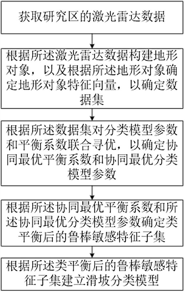
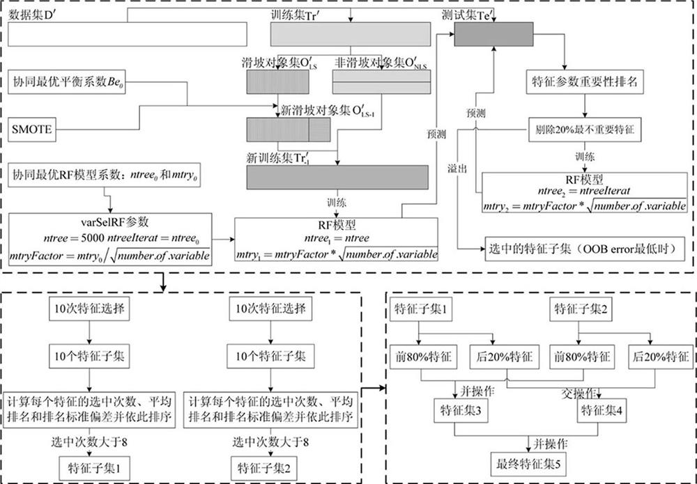
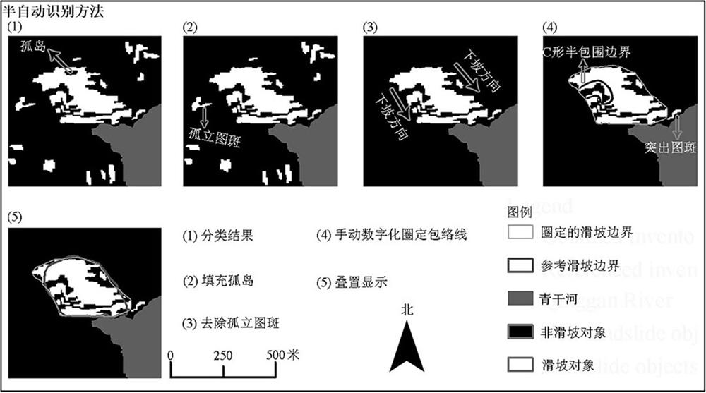
[0025] Landslides are widely distributed all over the world and are the second largest geological disaster after earthquakes, causing a large number of casualties and economic losses. Therefore, rapid and accurate identification of landslides has important theoretical and practical significance for landslide disaster prediction and early warning, disaster prevention and mitigation, and real-time assessment of disaster situations.

[0026] Remote sensing technology has the technical characteristics of large-area synchronous observation, strong timeliness, and the ability to realize dynamic observation, and has become the main means of landslide identification. The classification method based on optical imagery, terrain data and machine learning algorithm is currently the most effective and deeply researched landslide identification method, but the accuracy of landslide identification is not high. When the classification method is used to identify landslides, the landslide and n...


PUM


Abstract

The invention provides a complex background area landslide classification model establishment method and device and a complex background area landslide identification method and device, and relates toclass imbalance model establishment and landslide identification. The method for establishing the landslide classification model in the complex background area comprises the following steps: acquiring laser radar data of a research area; constructing a terrain object according to the laser radar data, and determining a terrain object feature vector according to the terrain object so as to determine a data set; performing joint optimization on classification model parameters and balance coefficients according to the data set to determine a collaborative optimal balance coefficient and collaborative optimal classification model parameters; determining a robust sensitive feature subset after class balance according to the collaborative optimal balance coefficient and the collaborative optimal classification model parameter; and establishing a landslide classification model according to the robust sensitive feature subset after class balance. According to the technical scheme, the landslide remote sensing recognition precision is improved.

Description

technical field [0001] The invention relates to the technical field of class imbalance model establishment and landslide identification, in particular to a landslide classification model establishment and identification method and device in complex background areas. Background technique [0002] In the prior art, in the field of landslide remote sensing recognition, the problem of class imbalance has not attracted enough attention. There are two problems in the learning method of remote sensing class imbalance: (1) lack of an effective method for optimizing the balance coefficient, resulting in the inability to obtain the optimal (2) The lack of a robust and sensitive feature subset after class balancing cannot provide an optimized data set for subsequent classification. These problems further restrict the improvement of landslide remote sensing identification accuracy. Contents of the invention [0003] The problem solved by the invention is how to improve the recognitio...

Claims


Application Information

Patent Timeline
Patent Type & Authority Applications(China)
IPC IPC(8): G06K9/62G06K9/00G06F30/27
CPCG06F30/27G06V20/13G06F18/24G06F18/214
Inventor 李显巨陈伟涛王力哲陈刚
Owner CHINA UNIV OF GEOSCIENCES (WUHAN)
Why Eureka
Try Eureka