Landslide change detection method, storage medium and electronic equipment based on remote sensing images

A remote sensing image and change detection technology, applied in the field of remote sensing technology, can solve the problem of low accuracy of landslide change detection

Active Publication Date: 2021-04-09
AEROSPACE INFORMATION RES INST CAS
View PDF2 Cites 0 Cited by
  • Summary
  • Abstract
  • Description
  • Claims
  • Application Information

AI Technical Summary

Problems solved by technology

[0004] The present invention aims to provide a landslide change detection method based on remote sensing images, storage media and electronic equipment to solve the technical problem of low detection accuracy of landslide changes in low vegetation coverage areas and bare land areas in the prior art

Method used


Image

  • Landslide change detection method, storage medium and electronic equipment based on remote sensing images
  • Landslide change detection method, storage medium and electronic equipment based on remote sensing images
  • Landslide change detection method, storage medium and electronic equipment based on remote sensing images

Examples


Embodiment 1

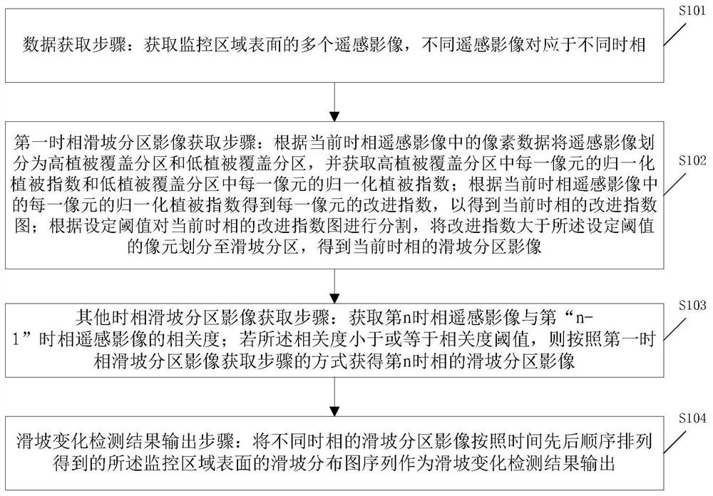
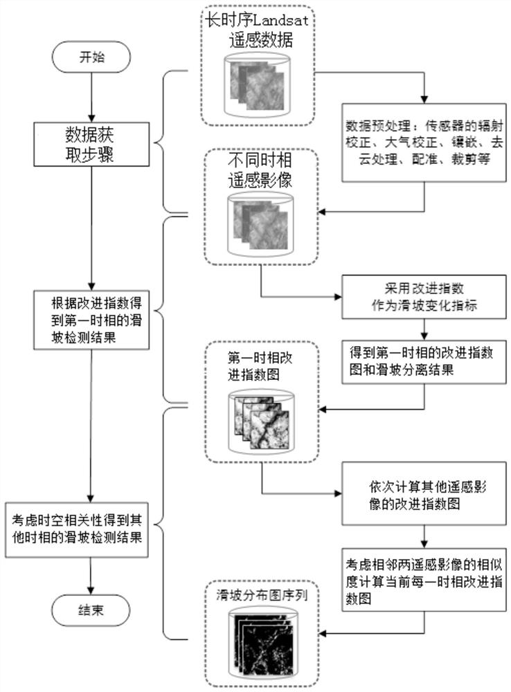
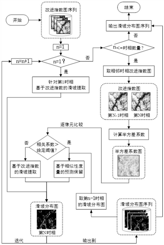
[0047] This embodiment provides a landslide change detection method based on remote sensing images, which can be applied to the controller in the landslide change detection system. figure 1 and figure 2 As shown, it includes the following steps:

[0048] S101: Data acquisition step: acquire a plurality of remote sensing images on the surface of the monitored area, and different remote sensing images correspond to different time phases; the time phase is preferably in the rainy season of summer time, preferably in July and August. For example, from 2009 to 2018, a remote sensing image is selected in July and August each year. Such as figure 2 As shown, the remote sensing image in this step can be obtained by using long-sequence Landsat remote sensing data, which may specifically include:

[0049] (1) After obtaining the Landsat remote sensing data, use the existing remote sensing software to convert the digital quantization value of the remote sensing data into physical qu...

Embodiment 2

[0062] The landslide change detection method based on remote sensing images provided in this embodiment, on the basis of the scheme of Embodiment 1, in step S102, the remote sensing images are divided into high vegetation coverage zones and low vegetation coverage zones according to the pixel data in the current phase remote sensing images Overlay partitions include:

[0063] S201: Acquire texture feature data of a remote sensing image, where the texture feature data includes texture average brightness data and texture image grayscale distribution uniformity data. Among them: texture feature analysis based on Gray Level Co-occurrence Matrix (GLCM) is a commonly used texture feature analysis method. It obtains the corresponding texture descriptor based on the statistical analysis of the gray level co-occurrence matrix to effectively express the texture features. The gray-scale co-occurrence matrix is ​​a symmetric matrix P obtained by counting the joint probability distributio...

Embodiment 3

[0081] This embodiment provides a computer-readable storage medium, in which program instructions for computer reading are stored, and after the computer reads the program instructions, it executes the method based on any solution in Embodiment 1 or 2. A Landslide Change Detection Method Based on Remote Sensing Imagery.


PUM


Abstract

The landslide change detection method, storage medium and electronic equipment based on remote sensing images provided by the present invention, wherein the method includes a data acquisition step; a first time phase landslide partition image acquisition step; other time phase landslide partition image acquisition steps and landslide change detection results output step. Among them, in the process of landslide partition image acquisition, the remote sensing image is divided into high vegetation coverage partition and low vegetation coverage partition, and the normalized difference vegetation index of different partitions is calculated separately to obtain the improvement index. Therefore, the high vegetation coverage partition and the low vegetation coverage partition The improvement indices in are different. Since the improvement index is obtained for different vegetation coverage levels, the landslide change detection results based on the improvement index can also be applied to natural surfaces with different vegetation coverage levels. Accurate landslide change detection results can be obtained in both high vegetation coverage and low vegetation coverage partitions.

Description

technical field [0001] The invention relates to the application field of remote sensing technology, in particular to a landslide change detection method based on remote sensing images, a storage medium and electronic equipment. Background technique [0002] As one of the most common natural disasters, landslides are second only to earthquakes. The monitoring and evaluation of landslides is a part that cannot be ignored in the work of rescue and relief, disaster prevention and mitigation, and an important part of the disaster monitoring system. The terrain of the landslide disaster site is dangerous, and it is difficult to monitor on the spot. Remote sensing technology has the characteristics of timely response, strong macroscopicity, good integration, periodic observation, safety and high efficiency, and rich information. Using remote sensing monitoring methods can quickly obtain dynamic change information of landslide disasters, and carry out fine quantitative analysis of ...

Claims


Application Information

Patent Timeline
Patent Type & Authority Patents(China)
IPC IPC(8): G06T5/40G06T7/12G06T7/136G06T7/194G06K9/00
Inventor 李山山张洪群冯旭祥陈勃冯钟葵李安吴业炜李宇陈俊石璐韦宏卫刘璐娇万广通
Owner AEROSPACE INFORMATION RES INST CAS
Why Eureka
Try Eureka