A method and device for automatically setting location attributes
An attribute and location technology, which is applied in the computer field, can solve the problem of cumbersome manual setting of map location attributes, and achieve the effect of improving user experience and simplifying operations.
- Summary
- Abstract
- Description
- Claims
- Application Information
AI Technical Summary
Problems solved by technology
Method used
Image

Examples
Embodiment 1
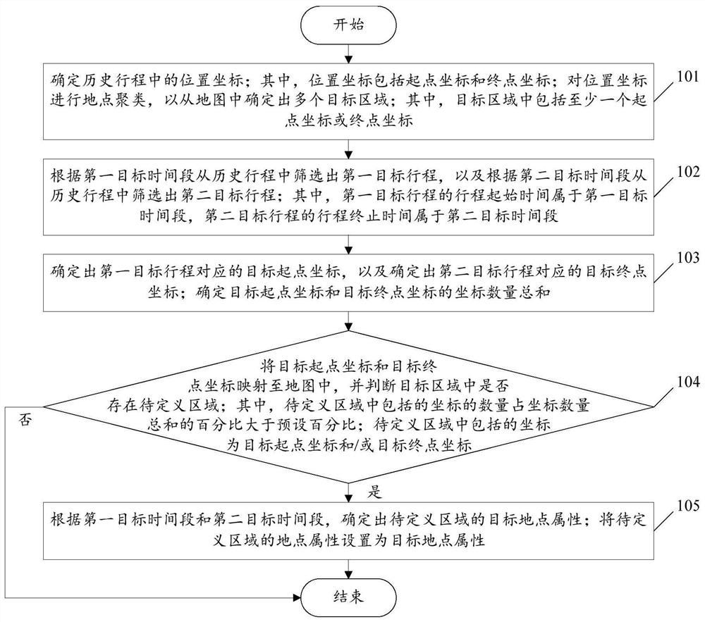
[0065] see figure 1 , figure 1 It is a schematic flowchart of a method for automatically setting location attributes disclosed in an embodiment of the present invention. Such as figure 1 The automatic setting method of the shown location attribute may include the following steps:
[0066] 101. Determine the location coordinates in the historical itinerary; wherein the location coordinates include starting point coordinates and end point coordinates; perform location clustering on the location coordinates to determine multiple target areas from the map; wherein the target area includes at least one starting point coordinates or end point coordinates.
[0067] In the embodiment of the present invention, optionally, the method of clustering the location coordinates may be:
[0068] The location coordinates are clustered by the K-means clustering algorithm (K-Means); or the location coordinates are clustered by the density clustering method (DBSCAN); or the location coordinate...
Embodiment 2
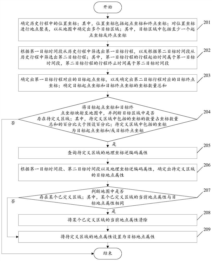
[0095] see figure 2 , figure 2 It is a schematic flowchart of another method for automatically setting location attributes disclosed in the embodiment of the present invention. Such as figure 2 As shown, the automatic setting method of the location attribute may include the following steps:
[0096] Steps 201 to 203, for the description of steps 201 to 203, please refer to the detailed description of steps 101 to 103 in Embodiment 1, which will not be repeated in this embodiment of the present invention.
[0097] 204. Map the coordinates of the starting point of the target and the coordinates of the end point of the target to the map, and judge whether there is an area to be defined in the target area; wherein, the percentage of the number of coordinates included in the area to be defined to the sum of the number of coordinates is greater than the preset percentage; to be defined The coordinates included in the area are the coordinates of the starting point of the target...
Embodiment 3
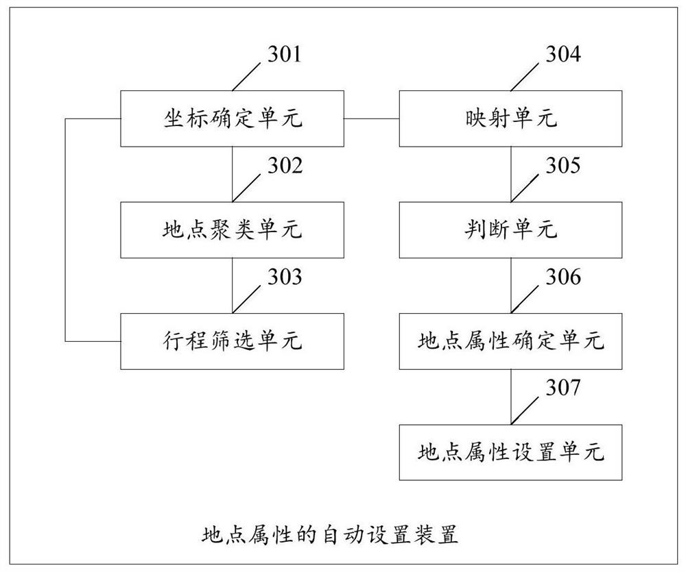
[0130] see image 3 , image 3It is a structural schematic diagram of an automatic location attribute setting device disclosed in an embodiment of the present invention. Such as image 3 As shown, the device for automatically setting location attributes may include: a coordinate determining unit 301, a location clustering unit 302, an itinerary screening unit 303, a mapping unit 304, a judging unit 305, a location attribute determining unit 306, and a location attribute setting unit 307, wherein :
[0131] The coordinate determining unit 301 is configured to determine the position coordinates in the historical itinerary; wherein, the position coordinates include starting point coordinates and end point coordinates.
[0132] In the embodiment of the present invention, optionally, the manner in which the coordinate determining unit 301 performs location clustering on the location coordinates may be:
[0133] Coordinate determining unit 301 carries out place clustering to pos...
PUM
 Abstract
Description
Claims
Application Information
 - R&D
- Intellectual Property
- Life Sciences
- Materials
- Tech Scout
- Unparalleled Data Quality
- Higher Quality Content
- 60% Fewer Hallucinations
Browse by: Latest US Patents, China's latest patents, Technical Efficacy Thesaurus, Application Domain, Technology Topic, Popular Technical Reports.
© 2025 PatSnap. All rights reserved.Legal|Privacy policy|Modern Slavery Act Transparency Statement|Sitemap|About US| Contact US: help@patsnap.com