Method for navigation electronic map pretreatment and display

An electronic map and display method technology, applied in the direction of electronic digital data processing, road network navigator, special data processing applications, etc., can solve the problems of unfavorable overall road distribution, narrowing the geographical scope, affecting driving safety, etc., and achieve road improvement The display effect and the effect of reasonable amount of road information

Active Publication Date: 2015-05-20
TSINGHUA UNIV
View PDF4 Cites 0 Cited by
  • Summary
  • Abstract
  • Description
  • Claims
  • Application Information

AI Technical Summary

Problems solved by technology

Usually in this case, the navigation user can only further understand the road information in the area by manually zooming in on the display scale, but zooming in on the scale will reduce the visible geographical range, which is very unfavorable for understanding the overall road distribution in a certain area. In addition, in car navigation, etc. Under the usage environment, operating the navigator while driving will seriously affect driving safety

Method used


Image

  • Method for navigation electronic map pretreatment and display
  • Method for navigation electronic map pretreatment and display
  • Method for navigation electronic map pretreatment and display

Examples


Embodiment Construction

[0015] The present invention will be described in detail below in conjunction with the accompanying drawings and embodiments.

[0016] like figure 1 As shown, the navigation electronic map preprocessing and display method of the present invention includes the following steps:

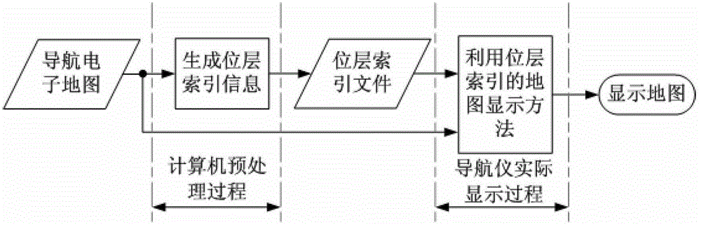
[0017] 1. Set up a navigation electronic map preprocessing and display system including a computer and a navigator. The computer is preset with the navigation electronic map used by the navigator. The electronic map preprocessing results are displayed.

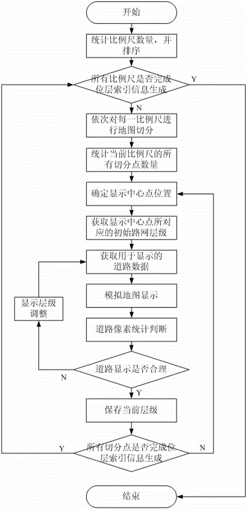
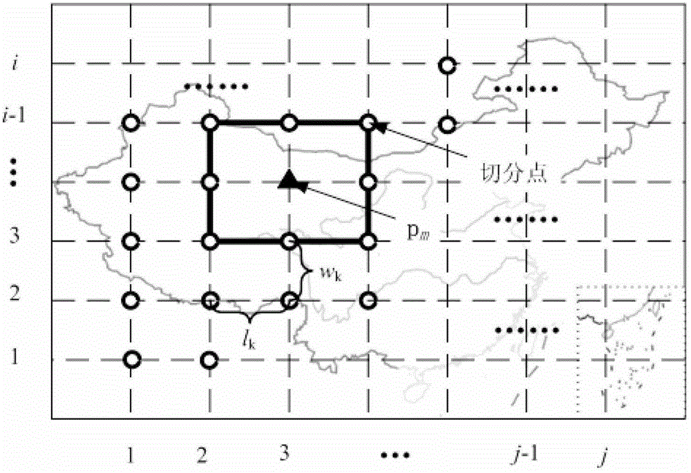
[0018] 2. According to the scale information of the navigation software used by the navigator, according to the order of the size of the scale, the layer index information of all segmentation points under each scale is sequentially generated (such as figure 2 shown), the specific process is:

[0019] 1) Count the number of scales in the navigation software, and sort the scales by size;

[0020] 2) Except for the largest scale, perform steps 3) to 4...


PUM


Abstract

The invention relates to a method for navigation electronic map pretreatment and display. The method for the navigation electronic map pretreatment and display includes that 1) a system for the navigation electronic map pretreatment and display is arranged, and the system for the navigation electronic map pretreatment and display comprises a computer and a navigator, 2) based on plotting scale information of a navigation software which is used in the navigator, layer index information of all segmentation points under each plotting scale is generated in sequence according to a size sequence of plotting scales, 3) judging if the layer index information of all the rest plotting scales except for a biggest plotting scale is generated in sequence is carried out, 4) layer index files are copied to a catalogue capable of being read by the navigation software of the navigator, 5) when a map is displayed by the navigation software, according to a current plotting scale and a display central point, display road network layers which are optimized are read from the layer index files, and road data which is reasonable in density is achieved and displayed. The method for the navigation electronic map pretreatment and display is capable of being widely used for vehicle navigation.

Description

technical field [0001] The invention relates to a map display preprocessing and display method, in particular to a navigation electronic map preprocessing and display method. Background technique [0002] The navigation electronic map is the basis for the realization of various functions such as car navigation map display, route planning, and navigation guidance. The navigation map display is to display the geographical information within a certain geographical range around the current position of the vehicle on the screen in the form of images, etc., to provide the driver with driving environment information. The geographical information in the navigation electronic map includes roads, landmarks, etc. The reasonable display of roads is the core part of the map display. [0003] In order to adapt to the weak computing power of embedded navigation devices, most of the existing navigation electronic maps organize map data in the form of layers and blocks, aiming at speeding u...

Claims


Application Information

Patent Timeline
Patent Type & Authority Patents(China)
IPC IPC(8): G01C21/26G06F17/30
Inventor 杨殿阁连小珉李江涛张照生张涛杨扬彭应亮张德鑫
Owner TSINGHUA UNIV
Why Eureka
Try Eureka