Method for forecasting real-time measurement of spatial geometrical information of coal rock dynamic disaster

A technology of geometric information and dynamic disasters, applied in earth-moving drilling, mining equipment, mining equipment, etc., can solve problems such as the intensification of the difficulty of basic theoretical breakthroughs, and achieve the effect of rapid prediction and continuous prediction.

Inactive Publication Date: 2011-06-22
CHINA UNIV OF MINING & TECH
View PDF5 Cites 32 Cited by
  • Summary
  • Abstract
  • Description
  • Claims
  • Application Information

AI Technical Summary

Problems solved by technology

So far, its occurrence mechanism, influencing factors and its internal connection have not been fully understood, and with the

Method used


Image

  • Method for forecasting real-time measurement of spatial geometrical information of coal rock dynamic disaster
  • Method for forecasting real-time measurement of spatial geometrical information of coal rock dynamic disaster
  • Method for forecasting real-time measurement of spatial geometrical information of coal rock dynamic disaster

Examples


Embodiment Construction

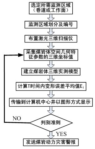
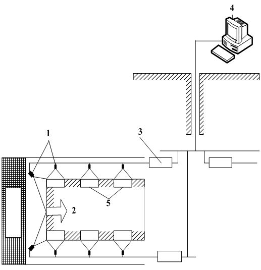
[0026] Such as figure 1 and figure 2 As shown, first select the required monitoring area, that is, select the area where the roadway or mining face 2 needs to be monitored, and divide the monitoring area into a plurality of early warning units 5 according to the measurement range of the laser three-dimensional scanner 1, and monitor the multi-warning units 5. A warning unit 5 numbers (such as: a, b, c, ..., i, ... n); in front of each early warning unit, arrange a laser three-dimensional scanner 1 whose scanning angle is not greater than the range, the distance between the laser three-dimensional scanner 1 and the early warning unit 5 = 1 to 10 meters; the laser three-dimensional scanner 1 Real-time and precise measurement of the three-dimensional coordinates of the spatial geometric information of the coal and rock mass in each early warning unit 5, and store the scanning results through the underground collection and processing substation 3; The three-dimensional measure...


PUM


Abstract

The invention relates to a method for forecasting the real-time measurement of spatial geometrical information of a coal rock dynamic disaster, comprising the following steps of: regarding a tunnel or a working surface as an early warning centre, and dividing a monitoring region into different early warning units; carrying out real-time measurement on the early warning unit through a laser three-dimensional scanner to obtain deformation error of the coal rock spatial geometrical information in the early warning unit; transmitting the measurement values of all the early warning units to a computer center and displaying in the graphic form; judging as a high stress danger unit when the measured deformation error is more than the early warning critical value; judging as a high stress increasing unit when the deformation error increasing ratio in the time is more than the critical increasing ratio; and judging as a high stress gradient unit when two or more adjacent early warning units are increased or reduced sharply. The district that the disaster is possible to take place is analyzed according to the early warnings under different situations, much more time is provided so that an operator can withdraw and take necessary measures, and a convenient way is provided for accurately forecasting the coal rock dynamic disaster.

Description

Technical field [0001] The present invention involves the field of coal mine safety monitoring and monitoring technology, especially a method of continuously measure the geometrical geometric information of coal rock body space through non -contact laser three -dimensional scanners to continuously predict coal rock dynamic disasters in real time. Background technique [0002] Coal rock dynamic disasters are a phenomenon of dynamic effects and disaster consequences that coal rock body occurs under the action of external stress. It mainly refers to the protrusion of coal and gas, impacting the ground pressure, the collapse of the top plate, and the deformation of the surrounding rock.The main body of the phenomenon of coal rock dynamic disasters is all kinds of unstable coal rocks. It is a process of rapid deformation and rapid development under the comprehensive effect of external physical chemistry and mechanics.Coal rock dynamic disasters have significant characteristics such as...

Claims


Application Information

Patent Timeline
IPC IPC(8): E21F17/00E21F17/18
Inventor 刘万里欧阳健飞朱华
Owner CHINA UNIV OF MINING & TECH
Why Eureka
Try Eureka