
GIS technology-based coal-series gas longitudinal development interval optimization method

A coal-measure gas and development method technology, which is applied in earthwork drilling, measurement, wellbore/well components, etc., can solve the problems of compatibility evaluation and numerical simulation of stagnant production layers, and visual identification of difficult-to-apply coal-measure gas layers, etc. question

Active Publication Date: 2019-11-29
CHINA UNIV OF MINING & TECH
View PDF2 Cites 7 Cited by
  • Summary
  • Abstract
  • Description
  • Claims
  • Application Information

AI Technical Summary

Problems solved by technology

At present, there are few studies on the optimization of coal-measure gas intervals at home and abroad, and they only stay in the aspects of production layer compatibility evaluation and numerical simulation; it is difficult to apply to the intuitive judgment of coal-measure gas interval optimization; for details, see: Meng Shangzhi, Li Yong, Wang Jianzhong, et al. Feasibility analysis of "three gases" single wellbore co-production in coal measures (1)—Discussion based on field test wells [J]. Coal Journal, 2018, 43(1):168-174; Zhang Fenna, Zhang Hao, Qi Yaoguang, et al. Current status of co-mining technology and adaptability analysis in co-mining of coal-measure gas[J]. Journal of Coal Science, 2017, 42(S1): 203-208; Lin Haixiao. Coal based on damage theory Research on evolution law of fracture network in gas reservoir stimulation[D].Henan University of Technology, 2016

Method used


Image

  • GIS technology-based coal-series gas longitudinal development interval optimization method
  • GIS technology-based coal-series gas longitudinal development interval optimization method
  • GIS technology-based coal-series gas longitudinal development interval optimization method

Examples


Embodiment Construction

[0070] The technical solutions of the present invention will be further described below in conjunction with the accompanying drawings and embodiments.

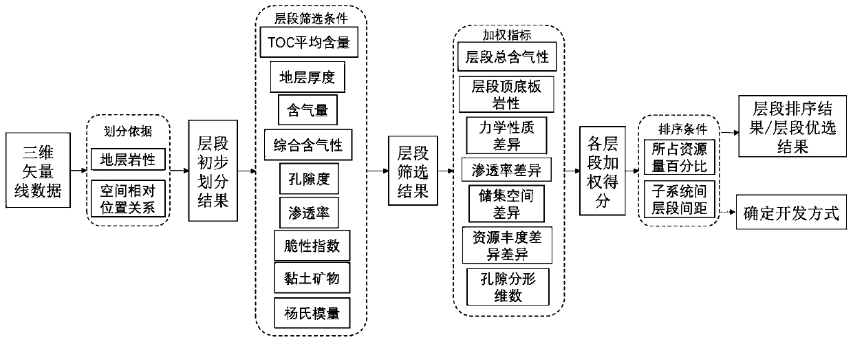
[0071] This example provides a GIS technology-based method for layer optimization of coal-measure gas vertical development, the process is as follows figure 1 shown, including the following steps:

[0072] S1: Collect the basic data of coal-measure gas single wells, build the basic database of coal-measure gas vertical development intervals, determine the lithology of each layer, and use GIS technology to construct a three-dimensional model of drilling holes; the specific methods are as follows:

[0073] (1-1) Collect coal-measure gas enrichment accumulation and development elements, including: coal-measure gas hydrocarbon generation capacity, reservoir storage performance, gas reservoir caprock conditions, and easy-to-recover information; collect geophysical prospecting, drilling, and mud logging , basic geological data;

...


PUM


Abstract

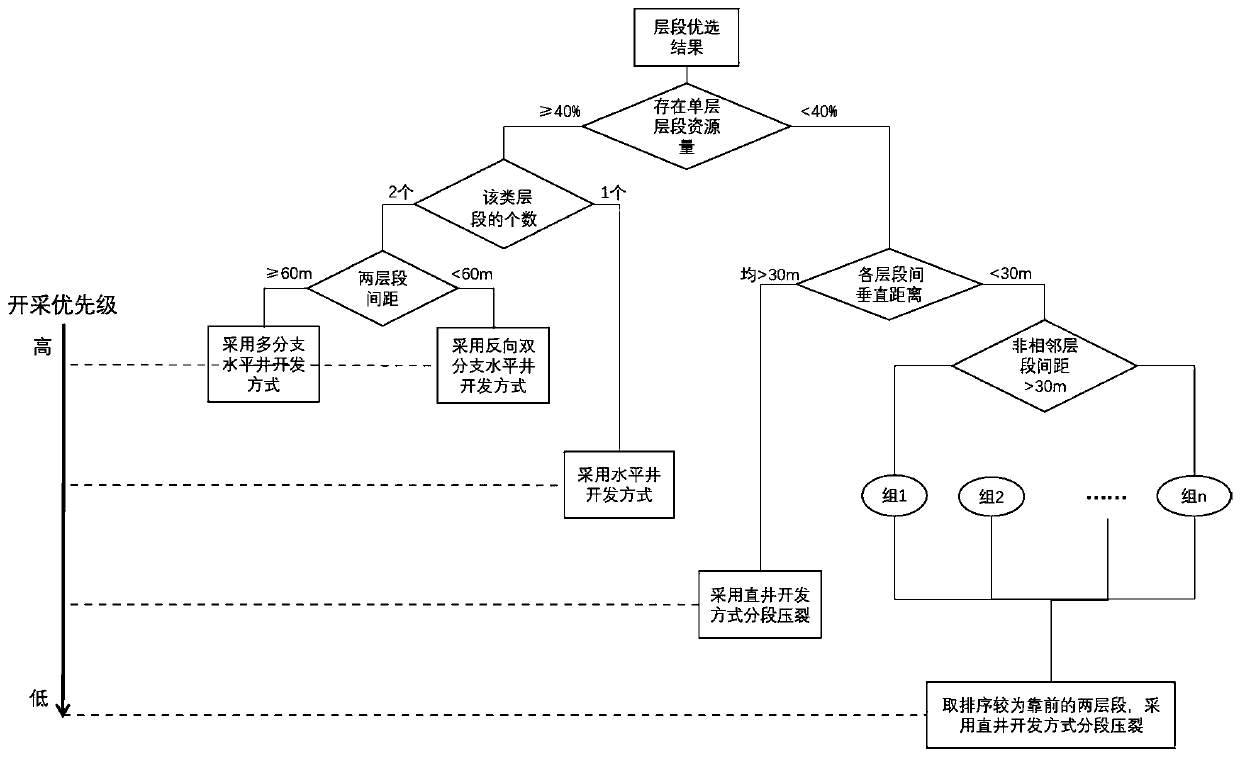
The invention discloses a GIS technology-based coal-series gas longitudinal development interval optimization method, including the steps: building a coal-series gas longitudinal development intervalbasic database, and preliminarily determining a coal-series gas longitudinal development interval according to a coal-series gas reservoir combination mode; constructing a coal-series gas interval optimal evaluation index system, and obtaining an interval screening result by utilizing an interval screening condition; selecting a weighting index, and determining the weight and score of each weighting index in the coal-series gas interval in an expert scoring mode; performing weighted calculation on the index score in each interval, calculating the proportion of the cumulative score of each interval in the cumulative scores of all the intervals, and sorting the intervals according to the proportion; and according to the score ratio of each interval and the distance between the intervals, determining the interval mining priority and the coal series gas development mode. The GIS technology-based coal-series gas longitudinal development interval optimization method is simple in step, reduces a large amount of repeated operation, achieves longitudinal coal-series gas interval optimization, has the advantages of being visual, vivid, rapid and efficient, and provides a more reliable basisfor coal-series gas exploration and development.

Description

technical field [0001] The invention belongs to the technical field of coal-measure gas geological area selection, and in particular relates to a GIS-based method for optimizing vertical development intervals of coal-measure gas. Background technique [0002] Coal-measure gas is an important part of unconventional natural gas in my country, and the exploration and development of coal-measure gas has become one of the hot spots in the energy field at the present stage. Coal Measure Gas refers to all kinds of natural gas existing in coal-measure strata, including coal-bed methane, tight gas and shale gas, also known as "three coal-measure gases". For details, see: Qin Yong. Research progress on co-generation and accumulation of coal-measure gas in China [J]. Natural Gas Industry, 2018, 38(4): 25-35; Qin Yong, Shen Jian, Shen Yulin. Co-production compatibility of superimposed gas-bearing systems—coal measures" Common geological problems in "three gases" and deep coalbed methan...

Claims


Application Information

Patent Timeline
Patent Type & Authority Applications(China)
IPC IPC(8): G06F16/29G06F17/50G06T17/00E21B47/00E21B49/00
CPCG06F16/29G06T17/00E21B49/00E21B47/00Y02A10/40
Inventor 王冉桑树勋刘世奇余悠然张婷王鹤吴翔谢雨心郑礼儒
Owner CHINA UNIV OF MINING & TECH
Learn More