
Aircraft-based mapping method, device and system

A technology for surveying and mapping devices and aircraft, applied in control/adjustment systems, instruments, three-dimensional position/channel control, etc., can solve the problems of poor safety, low surveying and mapping efficiency, and complexity of manual surveying and mapping methods, so as to improve the efficiency of surveying and mapping and solve the problems of surveying and mapping. Low efficiency, high efficiency effect

Pending Publication Date: 2019-02-05
GUANGZHOU XAIRCRAFT TECH CO LTD
View PDF9 Cites 10 Cited by
  • Summary
  • Abstract
  • Description
  • Claims
  • Application Information

AI Technical Summary

Problems solved by technology

[0004] In view of this, the embodiments of the present invention provide an aircraft-based surveying and mapping method, device, and system to solve the complex, time-consuming, and poor security of the existing unmanned aerial vehicle surveying and mapping methods. The problem of low mapping efficiency
[0006] The aircraft-based surveying and mapping method of the embodiment of the present invention can solve the problem of low surveying and mapping efficiency compared with manual dot surveying and mapping; compared with traditional drone surveying and mapping, it simplifies the surveying and mapping control process and improves the surveying and mapping efficiency. The corresponding high-precision route is mapped out in the internal survey

Method used


Image

  • Aircraft-based mapping method, device and system
  • Aircraft-based mapping method, device and system
  • Aircraft-based mapping method, device and system

Examples


Embodiment Construction

[0039] In order to make the purposes, technical solutions and advantages of the embodiments of the present invention clearer, the technical solutions in the embodiments of the present invention will be clearly and completely described below with reference to the accompanying drawings in the embodiments of the present invention. Obviously, the described embodiments These are some embodiments of the present invention, but not all embodiments. Based on the embodiments of the present invention, all other embodiments obtained by those skilled in the art without creative efforts shall fall within the protection scope of the present invention.

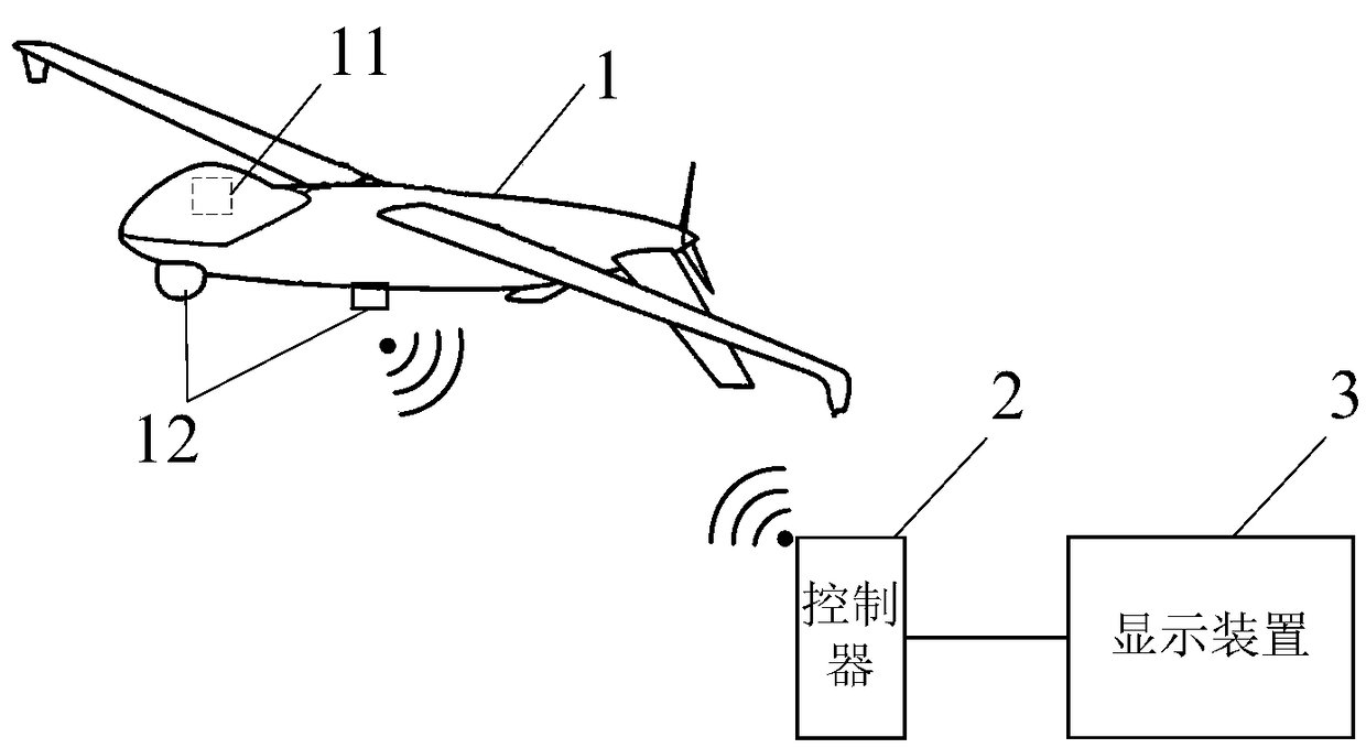
[0040] like figure 1 As shown, it is a schematic diagram of an application scenario of the aircraft surveying and mapping control system according to the embodiment of the present invention. The aircraft surveying and mapping control system mainly includes an aircraft 1 , a controller 2 and a display device 3 . The aircraft 1 includes a flig...


PUM


Abstract

The invention discloses an aircraft-based mapping method, device and system. The aircraft-based mapping method comprises the steps of acquiring an image of an aircraft during flight, and displaying areference mark and an image for alignment in an image display interface; receiving trigger operation input by a user; recording a mark point in the image according to the trigger operation; and acquiring position information of an actual mapping point corresponding to the mark point according to a mapping relation between the image and the true position. According to the aircraft-based mapping method disclosed by the embodiment of the invention, the problem of low mapping efficiency of a mapping person can be solved compared with artificial dot mapping; and compared with traditional unmanned aerial vehicle mapping, the mapping control process is simplified, the mapping efficiency is improved, and the corresponding high-accuracy position information can be mapped within a short time.

Description

technical field [0001] The invention relates to the technical field of UAV flight control, in particular to an aircraft-based surveying and mapping method, device and system. Background technique [0002] There are two main methods for map surveying and mapping, one is surveying and mapping by unmanned aerial vehicle. Generally, UAV surveying and mapping needs to plan the route in advance and then use the UAV to survey and map according to the route. In the later stage, the photos need to be stitched by software. This kind of surveying and mapping method is too complicated and time-consuming. For some routes that urgently need high-precision Not practical for the occasion. [0003] The other is to perform manual surveying and mapping. Manual surveying and mapping generally means that workers hold hand-held surveying and mapping equipment in their hands to manually walk on the sites that need to be surveyed and mapped (such as manual surveying and mapping of farmland boundar...

Claims


Application Information

Patent Timeline
Patent Type & Authority Applications(China)
IPC IPC(8): G05D1/10
CPCG05D1/101
Inventor 覃朝龙
Owner GUANGZHOU XAIRCRAFT TECH CO LTD
Learn More